Sam Osmanagich
THE
WORLD
OF THE
MAYA
Table of Contents
-
The Lost World of the Maya
Introduction
In Central America there are important messages from the Maya which have been recorded in their monumental architecture… left for us to read thousands of years later.
To decode these messages we need spiritual and material (scientific) research to work hand-in-hand.
Let us get down to work…
Guatemala City, Guatemala
Flying over Central America, below me nothing but vast jungle. Why did the Maya build their monumental cities in the middle of such a wild and inhospitable territory?
********
The Europeans first set foot on Central American land when Columbus made his fourth and final voyage in 1502. His ship came to Guanain on the Atlantic side of one of the islands of Honduras. To the great delight of Columbus’s son, the crew stole a canoe full of trading goods of the Maya – containing exotic items such as cocoa seeds, sea shells, Quetzal plums and fine ceramics. Columbus continued along the coast and discovered the Veragua region where he found enough gold to encourage other Spanish explorers to undertake further expeditions of plunder.
********
The airplane captain makes a wide loop around Guatemala City giving us time to get a good look at the three volcanoes which border this city of two million inhabitants. There are numerous shanty-towns all along the edges of the green carpet of the Guatemala plain.
This humble airport terminal has received all the races, and skin colors of Central America.
In contrast to the Europeans in North America, the Spaniards in Central America came not as settlers but as conquerors. They did not bring their families with them but they made children with the native women. The result was numerous mestisos which eventually became the majority of the population. The small number of peninsulares who brought their families from Spain were allotted positions at the top of the hierarchy. The presence of black slaves from Africa, all along the Atlantic coast of the New World as well as mulattos, is significant. There are also distinct groups of Chinese and of the Misquito and Darien Indians. And last of all, the descendants of the Maya maintained their bloodlines and racial heritage in most of the territory’s regions.
The ancient world of the Maya (el Mundo Maya) extended from the Yucatan peninsula of Mexico in the north to the forested region of the Chiapas in the west, the plains of Belize in the east, and the jungles of Guatemala, Honduras, and Salvador in the south. Some thirty different but related languages are spoken today by six million Indians who trace their roots back to the Maya.
The life of several million Indians who live off the land resembles the life of their ancestors. They grow the same crops (corn, beans, chili peppers, tomatoes and squash) their tools and methods are the same. Even their village social structure has remained unchanged. Plant medicine is their dominant form of health care. For the most part they are farmers struggling for survival in very humble circumstances.
Going back one and a half, or even two and a half, millennia we will find that the scattered villages of farmers had much the same kind of life. But there was one significant exception: in those ancient times in their midst there were monumental “ceremonial centers”, temples and pyramids, places for artistry and astronomy. Two worlds side by side.
********
For one explanation of the Maya phenomenon we can search throughout the world. Maya is a key Hindu philosophical term meaning “creation of the world” and “the world of illusion”. In Sanskrit “Maya” is connected with the concepts of “great” “measure” ”mind” and “mother”. For this reason, it may not surprise us to learn that Maya was the name of Buddha’s mother. The Veda tell us that Maya was the name of a great astronomer and architect. In Egyptian philosophy the term Maya means “universal world order”. In Greek mythology Maya is the brightest of the seven stars of the Pleiades constellation. Mayab is also the name of the seat of the Mayan civilization-the Yucatan peninsula.
We shall discover as we continue along the way that all these concepts and meanings are indeed appropriate to associate with the true identity of the Maya.
********
It is ironic that much of what we know of the Maya, and nearly all of what we don’t know, can be traced to the hands of a single person, the Franciscan monk, Diego de Landa. In the year 1562 he ordered the massive burning of all the Mayan manuscripts in the town of Mani, the Spanish headquarters in the Yucatan. As a result of this barbaric act, the largest single collection of Mayan literature and history was destroyed. Along with it the remaining spiritual leaders of the Mayan people also perished in the fire.
Later this same monk took pen in hand to write about the Maya of the Yucatan. He went into great detail about their customs, religious rituals, their language and writing system. But he was well aware of the fact that he was only touching the surface on this subject. “It is probable,” he says, “that this land holds secrets which have not be uncovered and which even the natives themselves are unaware of.”
When the Spaniards came to Central America, the original Maya were long gone, having left behind their magnificent abandoned cities and a whole world of mysteries to be decoded.
The ordinary folk who lived in the Mayan territory were in no way equipped to explain the cosmic philosophy of their ancestors. The technologically superior barbarians were confused by this. The Spaniards were making a significant mistake believing that these local natives were the Mayan race. And because of this, even today the Mayan name is used for the descendants of the poor farmers who lived there at the time of the original Maya-those who remained on this land after the sudden departure of their rulers and patrons.
“Ma” means “not” and “ya” means “pain”. The original meaning of the word “Maya” could be the condition “without pain.” In other words, “awareness without pain.”
The spirit’s presence in the physical body corresponds to a state or time of pain. Our body has physical pain, illness, old age and incapacitation. The spirit free of the body corresponds to a state without physical pain. Those who master the technique of leaving the physical body of their own will can live a spiritual life without pain.
The Maya are not a nationality. Nor a civilization. They are not the millions of impoverished inhabitants in Mexico or Guatemala. They are not the “proud” warriors of two thousand years ago who tirelessly fought with their neighboring cities in the jungles of Chiapas and Honduras.
The encyclopedias’ sketches and descriptions of the heirs of the Maya are misleading. The “Mayan civilization” has been falsely represented for the last 500 years. It is time for this misconception to be straightened out.
The Maya is a state of awareness. It is the life of the spirit which lives in harmony with cosmic processes. The Maya is the understanding that the physical body is a transient vehicle which assists in spiritual development.
Any one of us can be a Maya. In fact, this ought to be our aim-to attain the Mayan state of consciousness.
********
The Maya left their messages in their architectural achievements…to be read by generations thousands of years later. Spirituality and science should go hand in hand in order to decode these messages.
Geometry is the language of the universe. And the Maya, for this reason, left their messages in the form of sacred geometry on the walls of their temples and pyramids.
The Maya are creatures of the light. And the cosmic expressed through sacred codes in geometry, color, musical notes and alphabet.
When we are able to understand the messages of the Maya we will make one more step towards becoming ourselves one with the light.
Chiquimula, eastern Guatemala
It would be logical to expect that a city of 2 million would have a respectable bus station. However, instead of covered terminals there is nothing but narrow dusty streets. Instead of announcement panels showing names of destinations and times of departures there are only little Guatemalans calling out to potential travelers who should board their busses. And instead of comfortable busses there are nothing but beaten-up old and very used busses. Time of departure: when the bus is full.
Guatemala City is a huge village. The houses are unattractive, dilapidated. But, nonetheless, the people seem warm and outgoing. In much the same way as in other Latin American countries – Brazil, Venezuela, Peru and Mexico. The stories of crime, civil war and kidnapping of tourists are becoming a thing of the past. The current situation is that three of every one thousand tourists encounter such unpleasant experiences. Three tenths of one percent (0.3%) is no more than what is the case for New York or Italy.
********
The traditional culture of the Maya is divided into three periods: the pre-classical (several hundred years B.C. to 300 years A.D.), the classical (300-900 A.D ) and the post-classical (900-1500 A.D. and the arrival of the Spanish conquistadores).
In the last two decades, the starting point for the first period has been moved back further into the past. The discovery of new artifacts has enabled archeologists to establish this beginning at approximately 2000 B.C. (see “The Magnificent Maya” by Joseph Gardiner, 1986; The Magnificent Realm of the Mayas”, Readers Digest 1978;“Central America” by Cadogan, 1993; and “Maya Civilization” by Dr. William Fowler, 2003).
Guatemala City has buried beneath itself the ruins of an ancient center of the Maya-Kaminal Juyu. There once stood hundreds of buildings and pyramids at the heart of this city, with highly developed cultural and commercial centers of half a million Teotihuacanos who came from Teotihuacan (north of Mexico City). As long as thirty years ago radio-carbon dating had already established times of certain pyramids with nearby graveyards as dating back to before the time of Christ.
I would utterly dismiss and discard this division into 3 periods. And I would introduce a completely different approach to the Maya.
First of all, the genuine Maya have had, and continue to have, a single mission. Second, this mission spans a period of some five thousand years.
Ordinary watchmakers repair our watches and put them into accordance with Earthly time. It is my theory that the Maya should be considered watchmakers of the cosmos whose mission it is to adjust the Earthly frequency and bring it into accordance with the vibrations of our Sun. Once the Earth begins to vibrate in harmony with the Sun, information will be able to travel in both directions without limitation. And then we will be able to understand why all ancient peoples worshipped the Sun and dedicated their rituals to this. The Sun is the source of all life on this planet and the source of all information and knowledge.
And with a frequency in harmony, the Earth will, via the Sun, be connected with the center of our Galaxy. These facts become exceptionally important when we realize that we are rapidly approaching December 2012, a date which the Maya have marked as the time of arrival of the Galactic Energy Cluster which will enlighten us.
Modern astronomy finally established only twenty years ago that there will indeed be a galactic energy crossing/cluster where the Earth and the Sun are in a special alignment which happens only once in 25,000 years. The Maya were aware of this simple cosmic truth some 2,000 years ago.
Their calculation of the time of Earth begins with the year 3113 B.C. and ends with 2012 A.D.
If we are to find the time of the appearance of the cosmic Maya on our planet, it will not be just going back to a few hundred years B.C. It will not even be only going back to 2000 years B.C. as established by the findings of modern archeology. Rather, we should go back still further to the year 3113 B.C. This would be when the Maya first appeared on Earth. And the date set for the final departure of the last Maya – “the protectors of knowledge” who are still present in the jungles of Central America – is the year 2012 – nine years from the time of this writing.
We will come back to these propositions later in this book.
And because of them our history needs to be re-written.
********
For five dollars you can cross Guatemala from north to south by bus. You can see all 30 of the volcanoes scattered along the 250 miles of Pacific coast.
My bus was going east, to the city of Chiquimula. In the late afternoon hours it seemed like all the inhabitants had come to the square in the center of town. Children in school uniforms were walking in small groups. Shop owners were in front of their shops trying to attract customers. Most of the young people were sitting in the park discussing the local football team.
At a small hotel with just a few rooms, I get myself a room for six dollars, and both the hotel owner and myself consider that we’ve made a good bargain. Two beds, a fan, and a bathroom. No hot
water, but, for that matter, no cold either. It’s a warm summer day and the air feels heavy. Large drops of sweat try their best to cool the body. There’s a very narrow balcony with a view overlooking the main street. I turn back into the room. The walls are not smooth but hunched over. The fan pushes the air around the room. Before my eyes are scenes out of the novels of Marques; the slow passage of time and the Latin American fate of the heroes.
At Sunset all of the stores are closed; the streets become empty until Sunrise. My fan rattles throughout the night. I wake up several times thinking I am in an airplane. Then I realize it’s not aircraft engines I am hearing but the fan. I switch it off. After a few minutes I switch it back on. Can’t stand it when it’s on, but it’s even worse when it’s off!
I haven’t worn a watch for over twenty years. When traveling I always wake at the crack of dawn. My small backpack was packed last night. I notice at the reception desk that it is 6 a.m. The owner is sleeping on a collapsible cot. He drowsily opens the door for me to go out. I head for what is considered the “bus station.” I catch the first bus headed for the border with Honduras – El Florido.
********
Guatemala’s history is the saddest of all the countries of Central America. The Spaniards ruthlessly annihilated the Indian tribes in the 16th and 17th centuries. Industrial slavery has characterized the last 250 years. A small, conservative elite of landowners has both the army and the economy under its control. For the past 100 years foreign “investors” have ruled the coffee market (85% of the export of this country). The United Fruit Company – owned by Americans – came here in the 1930’s lured by big concessions – in fact, a total monopoly – and it owns land, ports and the railway. The local ruling class has become totally dependent on American corporations. Guatemala and Honduras are the original “banana republics”. And the local dictators (like the state terrorist, “president” Manuel Estrada Cabrera who ruled 1898-1920) have become major figures in novels about political repression (such as “El Senor Presidente” by Miguel Asturias). The land was stolen from the Indians and “in return” they have had to work on the coffee and banana plantations. According to the law, even without fair compensation.
In the first free elections – in 1944 – the teacher and writer, Juan José Arevalo was elected president. He and his successor, Jacobo Arbenz, began land reforms and legalized a multi-party system (including the communists). The United Fruit Company quickly sought the assistance of its friends in the U.S. government. First sanctions were applied to Guatemala and then the CIA instrumented a military coup, with troops invading the presidential palace. The troops refused to defend the president, Arbenz, and he left the country in disgrace, and democracy came to an end. Things returned to the previous ways; repression continued for the next four decades. Uprisings by the Indians in the interior were put down – it was commonplace for the army to put all the women and children into a church and then set fire to it. The men would be forced to listen to their screams for help. Then they would all be shot. The occasional survivor would recount the horrors of the Guatemalan army in pages of the records of Amnesty International and refugee camps in Belize and Mexico.
********
Among the scientific achievements of the Maya, the first thing to be discussed is usually the calendar. It is an established fact that the Maya calculated the time of the Earth’s revolution around the Sun with incredible precision. Archeologists have confirmed that they did this without the use of precision instruments. In addition the Maya had calendars of the moon’s phases and eclipses. And even very precise records of the movements of Mercury, Venus, Mars, Jupiter and Saturn.
On certain of their monuments (at Quirigua, Guatemala) the Maya had recorded cosmic events which had occurred 400 million years ago.
Why? and how?
Archeologists generally view these calendars as nothing more than a means of recording time. But why would anyone devote so much time to the marking of time with such accuracy and precision?
Do numbers have a deeper meaning in cosmic relations? Do they convey, in addition to the coordinates of space and time, something else as well? And is this something accessible to our physical senses?
Could these numbers have their own frequencies? Could they also carry their own resonant characteristics? …and describe beings, planets, and experience?
Do the incredibly precise numbers of the Maya contain within themselves a cosmic code for each and every one of us? And does each number represent a piece of information which gets sent out into the universe?
Every number may be a piece of information and every piece of information a certain frequency. Communication – the exchange of information – can go on between living beings, between planets and between solar systems.
Can we evaluate the Maya with our science and technology? Do we think that because we have no evidence that they had spaceships, computers and telescopes that they are intellectually inferior?
If we approach the Maya with an attitude of superiority we will never be able to understand and decode what they represent. But if we approach them as students who desire to learn something from them, then there is hope for us.
We must realize that their science, their intellectual achievements, and their mental capacities were far in advance of our own.
They were able to achieve so much with so little. Technology was not important to them, nor did they use it. Let us forget about the telescope and the wheel. There exist other means of working stone and building pyramids, and for planets to be seen from various angles of the universe.
********
The Hopi Indians who live in the Grand Canyon in Arizona have an interesting legend known as Palat-Kwapi. It is connected with the Mysterious Red City in the south. It is actually both city and temple. The sole purpose of this city was to represent a system of knowledge and information. The workers were sworn to abandon the city as soon as it was completed. This was because this city was intended to function as a colossal book of knowledge for future generations.
However, the new generations forgot this ancient commandment. They moved into the city and resided there and while residing there they set out to conquer from there and were themselves conquered while residing there, and eventually the city was left utterly abandoned.
This Hopi legend gives a good idea of what happened with the Maya. They built fabulous temple-cities, too, only to have succeeding generations forget their original intent and turn them into places of residence and centers for religious rituals.
The Maya, who were travelers through the universe and cosmic watch-makers, would occasionally come to this planet and adjust our time with cosmic information, preparing us for the great energy leap in the year 2012 A.D. Upon each accession of their visit, they would leave behind a great treasure of knowledge.
Their visits resulted in cities which were built at various times; Teotihuacán (Mexico), Monte Alban (Mexico), Tikal (Guatemala), Copan (Honduras), Kaminal Juyu (Guatemala), Palenque (Mexico), Uxmal or Chichen Itza (Mexico).
I mentioned earlier the Maya ”keepers of knowledge” who are even today left on the planet. In the book “The Mayan Factor” (by Dr.José Arguelles, 1987), I came across this: In the beginning of 1985 I was contacted by a Maya by the name of Humbatz Men. In our conversations I learned that he was using seventeen different Mayan calendars. Archeologists know about only six of them. I met Humbatz finally in Boulder, Colorado where he was giving a lecture entitled “the Astronomy of the Maya.” The key part of his presentation and his knowledge was given in his concluding remarks. Humbatz stated that our solar system is the seventh such system which has been mapped by the Maya so far.
********
The road winds through the Guatemalan vegetation. I close my eyes and I can hear the footsteps of the Maya as they pass along the narrow pathway between two cities.
(Now I open my eyes). We arrive at the border town, El Florido. Instead of a place for currency exchange, there are only black marketers. Instead of a border station just two dilapidated shacks. Instead of computers, lots of bits of paper and rubber stamps. I begin to negotiate the price for the next leg of my journey.
Language and Symbols of the Maya
El Dorado, the Guatemala-Honduras border
The border opens at eight in the morning and closes at six in the afternoon. There is a very casual atmosphere. Papers are being stamped in the wooden shacks. An occasional truck passes (full of bananas, of course). The electricity goes out on two occasions but this causes no inconvenience to the officials working here. They have no computers – just a couple of manual typewriters. I wonder whether any changes have occurred in the past 50 years.
********
Over a period of 3,000 years the Maya have recorder knowledge of astronomy, legends about the Earth and the Cosmos, their own history and art.
Their favorite medium was picture books which were folded in several places. They were known as Codexes. To our knowledge there remain today only four such books. Three are named by the city of the museum where each is located: Dresden, Madrid, and Paris. The fourth is so called Grollier Codex.
The writing system of the Maya is very complex. Despite intensive research on their epigraphs much remains unexplained. It is a system combining “glyphs”-which represent whole words or processes-and smaller combinations of sounds-syllables. Thus far about 800 distinct glyphs have been identified, but only about a quarter of them have been associated with what is believed to be their meaning. This type of picture symbols known as “logographs”. An example is the word for “Jaguar” is represented by a sketch of the head of a jaguar.
Certain words which are not easily represented by the picture are instead represented by a word which sounds like that word. For example, the word ”to count” (“shok” in Mayan) is represented by the head of a mythical fish which is also called “shok” in Mayan.
The combination of words and symbols would often like riddles. Every symbol had several meaning; every picture could also be interpreted in several ways (literally translating the item represented or via the pronunciation with a different meaning). Does the word “shok” stand for “counting” or for “fish”?
The glyph with a stylized smile (a picture of a smile) and two small squares (“two front teeth”) has at least the following meanings: spirit, breath, wind, cosmic, energy, inspiration, a principal of life, the respiratory system, the north!
We can barely begin to imagine the possible combinations of these 800 symbols. What knowledge of the spiritual is necessary to decode them or to write them!?
But not only does every word have several meanings but a given word may be written in more than one way. For example, as we have already mention the word “jaguar” can be represented by the symbol or sketch of the head of a jaguar. But it can also be written syllabically, ba-la-ma, with the syllable symbols for “ba”, “la”, and “ma” – a way of spelling the word “balam”-which means “jaguar” in Mayan.
The Maya were able to represent with their hieroglyphic symbols their entire spoken language everything from sounds to grammar and syntax.
By comparison with their writing system, ours could be considered superficial, simple and incomplete.
Four hundred fifty years ago the Spanish bishop Landa attempted to transfer the concept of the written language of the Maya into the Western European alphabet. In conversation with a local priest he encountered certain things which he could not comprehend-for example pictures, sometimes represented letters, and certain words were pronounced the same but had different meanings, such as the words for ”sky”, “four”, “snake”, and “captive”, but the context had to be relied upon to provide their meaning. Having seen that the Spanish high representative of the church was incapable of escaping from his limited mind set, the Mayan interpreter wrote a note one morning in Landa’s book which said “I can’t continue” – and he left.
********
In the photographs which I took in Copan, the Honduras region of the Maya, I discovered several glyphs which had been carved in stone. The pictorial symbols come in a series of four. They are to be read in clockwise order. The first picture is added to the second, which is added to the third… and thus the total meaning is completed.
Our language is much simpler (which in this case is not an advantage). Our words, made up of letters or sounds, for the most part do not get changed in meaning regardless of what comes at the end of the sentence.
With the Maya, their picture symbols communicate with one another, they digest one another, and they build upon one another.
To make matters still more complicated, there are certain glyphs which seem to be of extra-terrestrial origin. In the photo shown here the head is strikingly like something out of science fiction. Two bulging hemispheres of the brain, the eyes of a reptile, and strange wavy lines beneath the chin. I have no doubt that this is one of the 600 which have not been deciphered.
********
June fifth – the first qualifying game in the world championship in soccer. The home team – Honduras – squeaks by the Salvador team 1-0. For the second game, Salvador turns fierce in the extreme. The hotel where the Honduran team is staying is set on fire. During the night they look for lodging under police protection. When they find it, they are “serenaded” by Salvadoran fans throughout the night. In the next day’s game the Hondurans look like zombies and are easily defeated 3-0. After that both countries experience severe disturbances, mostly persecution of Hondurans in Salvador and vice versa. The deciding game is to be played in neutral Mexico. On that 28th of June, 1968, all of Central America is glued to the TV or radio. Salvador wins in overtime with a score of 3-2. Insults are exchanged at the highest levels of government and a hundred-hour long war is begun. The army of Salvador prevails, but the Organization of American States, with the threat of a blockade, backs them off.
The net balance of the soccer war is 2,000 dead and 100,000 Salvadorans chased out of Honduras.
Honduras is five times bigger in land mass than Salvador, but it has a million fewer people. Its total population is four million (to Salvador’s five million). It would be difficult to say which nation is poorer, because 80% of the population of both countries does not earn enough to feed itself.
Of the estimated total population of 450,000 Indians in Honduras, half were killed by the Spaniards in the 16th and 17th centuries. A further 150,000 were sent as slaves throughout the area from Peru to Guatemala. Nowadays there are about 80,000 Indians left mostly from the Lenkas tribe who remain without land and who are otherwise pretty much left deprived of any rights.
In the 19th century the only thing grown here was bananas. Poor Honduras had such a weak government that in the course of 55 years (1821-1876) it had 85 different presidents. This country did not have its own central bank nor its own currency until 1953. The profitable export of the bananas was left in the hands of America corporations from whom it was expected that they would create the necessary infrastructure (roads, railway, ports, airports,) and invest capital in the economy. Instead, the United Fruit Company and Cuyamel kept political control of the country and of the economy, keeping the profits entirely for themselves.
Honduras had been sold and had become what was known as a “banana republic”. Nowadays this term can be traded for “pentagon republic” thanks to the military presence of the Americans.
********
A few hours of riding gave me a change to familiarize myself with the peaceful countryside of the Copan valley. This part of Honduras was the only part inhabited by the Maya, lying on the southernmost edge of their territory. After a steep climb (which I wasn’t sure my horse was going to be able to withstand), we arrived at the forest which contained the archeological findings known as “Los Sapos” – the place of birth. The small stone complex even after thousands of years of erosion still bears the symbol of the frog. This is supposed to be the place where the first Mayan mother gave birth to her children. Frogs are the symbol of fertility among the Maya.
The surface of the worn stone is surprisingly not uncomfortable – one might even say luxurious. My legs are resting on both sides of the head of the frog. Babies were supposedly brought into the world on the flat surface of the frog’s head.
I lie on the stone and try to put myself in touch with the past. Did pregnant women really climb up onto this plateau in order to give birth in this place? If they did the first view of the world which the newborn would have would be of the splendid Copan valley.
********
Western civilization only came to grips with the concept of zero in mathematics in the 12th century when they first encountered Arabic numerals. It is now the commonly accepted system of numbers – from zero to nine and then combinations of these ten numbers – which constitutes the decimal system.
The Arabic numeral system is derived from a still older system from India – there is evidence that they used zero in their system as early as the 6th century B.C.
One of the earliest civilizations we know of – that of Samaria – had a numerical system based on the number 60 (which is what we use for the number of minutes in an hour and the number of seconds in a minute, as well as the 360 degrees in a circle). The numbers themselves are expressed with a stylized symbol of a chalice such that the number 421 is four chalices, a space, two chalices, a space, and one chalice.
Next, in Babylon the space was used to represent zero and this made for a significant step in arithmetic. The Egyptian used two ways of expressing numbers – one, their hieroglyphics and the other using a vertical line for “one”, an inverted “v” for “ten”, a sheath of wheat for “100”, a lotus blossom for “1000”, etc.
The Hebrew, Greek, and Roman systems were similar, in that they used letters of their alphabets to represent numbers, with “A” for one, “B” for two, etc. They had no zero, and the concept of negative numbers did not exist. The Chinese had already developed a system utilizing vertical and horizontal lines, with zero represented by a square, which they were using already more than 2,000 years ago.
The Incas had a fascinating numbering system, with a base of 20. Using only three symbols (a period, dash, and a shell representing zero), the Maya were able to record any number. One period was “one”. Three were “three”. A dash represented the number “five”. Three dashes represented 15. Three dashes with three dots on top represented 18. For numbers over 20 a row is put above the first row. Thus the number 234 is represented by two rows – the number “11” (two dashes and a dot) on the top, representing 11 sets of 20, or 220, and the number 14 (two dashes and four dots) in the second row. For still larger numbers a third row is introduced. This represents the product of 20x20 or 400. A fourth row is used for values over 8,000 (20x20x20). Zero is represented by a stylized shell (or a small extended ellipsis). Thus the Maya completed their advanced mathematical way of thinking – even with the value of “nothing”.
When one looks at Mayan ruins it seems as if they were using this system since day one, five thousand years ago. The system is simple, very flexible and it is easy to use to calculate even transactions involving large numbers.
Our modern and generally accepted world-wide system has ten (0-9) symbols, whereas theirs has only three symbols.
Using our numbers we can express any number with simple addition; we can go back endlessly into the past and, similarly, far into the future. This is done by archeologists and biologists, going back ten thousand years, a hundred thousand or even millions of years into the past to describe life on Earth. This was also done by the Maya. On one stone tablet there is indication of a date of one billion eight hundred million days (more precisely, 1,814,639,800). This is the equivalent of 5.1 million years. Exactly what was being described has not yet been deciphered. Whatever it was, this is an indication of the fact that the Maya were concerned with ancient history and pre-historic times.
Tzolkin
Copan Ruinas, Honduras
Two of us split the cost of the driver. He was from Florida, I was from Texas. Our fare was $1.50 each. Along the way we had picked up Ladinose – a mixture of Lenkas Indians and mestizas. It is 8 miles from the border to Copan, the artistic center of the Maya.
There are two ways to get to this archeological gem in Honduras. The first is via the capital of Guatemala, to the border, then a few bus rides from there (to the border and on to Copan). That’s the route I had chosen.
The second is by airplane to San Pedro Sule, in the north of Honduras. (There’s a direct flight there from Houston.) Then a 3-hour bus trip to Copan. This is the tourist route. For the last few years it has been reasonably safe. The rebels from the northern jungle of Honduras had not recently made themselves felt.
As it happened, the day after I arrived there was a “kidnapping” of the “safe” bus from San Pedro. The outcome was tragic. Eighteen passengers were killed. From what I was able to make out of the local news broadcast, the rebels just wanted to make their presence known and to show that they could hinder the tourist trade if they wanted to.
This time I had apparently been guided by an unseen hand in my choice of which way to come to this location.
********
A letter dated March 8, 1576 is written by Doctor Don Diego Garcia de Palacios, member of the Royal Audiencia of Guatemala, addressed to the King of Spain, Phillip II. In it he describes the discovery of the ruins of Copan.
This is believed to be the first European document about this subject. Most of the archeological sites of the Maya are given arbitrary names based upon names of European origin. This is not the case here. Don Diego mentions that the name “Copan” was in use by the natives at the time (in the 16th century).
The meaning of the name is still in dispute. Some say it is the word for “bridge”. Others say that “pan” means “the capital city”, thus “Co” is the name of this capital.
It seems to me that both could be correct. As I see it, Copan is a kind of bridge, a gate to the universe, but also a capital city of the Maya which is of universal significance.
********
The official history books talk about “the obsession of the Maya with time”. They list the Mayan calendars (1) “The long one” which begins at day one, in the year 3114 B.C. and runs until the year 2012 A.D., (2) the “religious” calendar which has 260 days – 20 months of 13 days each, and (3) the “solar” calendar of 365 days – 18 months of 20 days each plus five extra days.
No-one disputes their very precise calculation of the solar year for the planets of our solar system. The Dresden Codex, for example, contains a table of the elliptic movement of Venus and its eclipses.
In places it is pointed out that the fascination of the Maya with time is not scientific in our sense of the word; their time was circular and the cycles would repeat themselves (“the rulers had to repeat the rituals and activities of their predecessors”). Explanations stop at this and go no further.
We shall attempt to go further in order to put the pieces of this puzzle together.
We have the unexplained pictoglyphs of the Maya and we have a complex awareness of the universe and of the planet Earth. This includes a very adaptable and useful system of counting which is applied, in one of the documents which we have, to dealing with the Earth millions of years ago. According to their own words, the Maya have a “cosmic” or universal mission. The three (or six) calendars which we have found in their documents are a part of the twenty calendars which the Mayans today use in their mission as “the guardians of knowledge.”
It is obvious that these calculations are not the ultimate purpose in and of themselves. The Maya are telling us much more.
********
Chilam Balam, a Mayan prophet falls into a trance and the only words he speaks are the numbers 1, 13, 7, 9 and 4.
Are these numbers just numbers or are they something more?
Are numbers alive? Are they ethereal entities? Can they occupy the spiritual dimension of our mind? ... a dimension beyond the control of our materialistic comprehension of the world?
Can the complete story of the Maya, the planetary and cosmic history, be expressed using numbers? Specifically, using 13 numbers and 20 symbols, in other words, with a matrix of 13x20?
Archeologists use the term Tzolkin for the calendar of the Maya of 20 months, each month 13 days long. The original name for this “secret calendar” is unknown, but it is known that it is more than just a simple calculation of days on this planet Earth.
Tzolkin is a code; our alphabet is also a code. Whoever knows the 30-odd symbols of our alphabet has enormous power, because through the written word we can express knowledge and wisdom of a seemingly limitless extent. Similarly, the encoded language of Tzolkin has its own cosmic worth.
We have programmed our brains to think of numbers as quantifiers, e.g. 13 land-mines or 7 bananas. But this is only one of the functions of numbers.
It is useful to think of musical tones. Do-re-mi-fa-so-la-ti… 1, 2, 3, 4, 5, 6, 7,… There are also different octaves, tone sequences, synchronization of two or more tones, etc. The possibilities are unlimited. But it all begins with the small set of seven tones.
What we refer to as time, the Maya referred to as harmonic resonance. Days are not 24-hour long periods of time but tones (“kim”) which are represented by numbers. Groups of days create harmonic cycles … and these cycles are part of one larger organic order in the universe.
Our planet Earth is a part of that harmonic system by means of its relationship to the Sun and, still further, with the Galaxy.
With the adjustment of musical notes, we are able to go to a higher octave. What would be “a higher octave” in the spiritual world? Another dimension!
So, by means of numbers, by adjusting frequencies, we can go through different dimensions.
So what can we conclude from the explanation of the archeologists who say that the Maya were “obsessed with calculations”? Only that they have completely overlooked or misinterpreted what the Maya have left us.
The system of numbers and hieroglyphic symbols of the Maya, so carefully carved in stone in their monumental structures, represents a system of cosmic frequencies which fit into the harmony of the Galaxy.
The cycles of time of the planet Earth and of the Sun, the planetary years of Venus, Mars and Jupiter… were for the Maya a challenge… with the goal of adjusting the Earth’s frequencies and making them harmonious with those of the Galaxy.
(These passages are inspired by the book “The Mayan Factor”, 1987, by Arguelles.)
Can numbers have such meaning and such power?
For the Maya, numbers are not what we think of them as being. For us the number “ten” is just one number larger than “nine.” For the Maya each number has its own qualities. It could be represented or described as a cosmic entity of its own which radiates rays of energy in all directions simultaneously.
And the Galaxy can be described as a vast unending flow of energy… in which sets of numbers are pulsating and radiating.
Somewhere, of course, there must be the source. This is the galactic center, which the Maya called Hunab Ku. There are incredibly bright energy forces which depart from and return to this source.
The Maya represented this energy flow in both directions with the numbers 1 to 13 (and from 13 to 1 for the other direction). From simple to complex energy pulsation … and back.
Thus the numbers become magical – separate entities, with various levels of resonance… They obtain the status of beings through which it is possible to change dimensions and travel through the cosmos.
For the Maya the Tzolkin is a universal table of cosmic frequencies. The numbers go forward and back communicating with one other. This is what we, with our own limited terminology, refer to as “time.” Our problem is that with our concepts “time” flows only in one direction, from the past to the present and on into the future. But that is only half the picture. The Maya clearly had a more complete picture of cosmic time.
The purpose of the mathematics of the Maya was not simply the calculation of time and establishing rainy and dry seasons and the best time for planting crops. This well-worn archeological explanation was very low on the list of reasons. Instead, the Maya used the magic of numbers to discover the galactic constant of the Tzolkin.
The numbers on the stone monuments of Copan and elsewhere show the relationship between the galactic harmony and the annual cycles of the Earth, the Moon, the Sun, Venus, and other celestial bodies.
The Maya constructed blocks of ornately decorated stone. But the blocks were not primarily just an artistic achievement of the Maya. They were time markers by means of which the Maya recorded the passage of five, ten and twenty years. The years were not their primary focus, however, but rather harmonic numbers and their calibration. Cycles of five, ten and twenty years correspond to frequencies of galactic energy units or bundles.
The diameter of a galactic bundle is 5125 years. Their galactic constant is a “calendar” of 260 units. (Archeologists are still “confused or “unclear” as to what these 260 “days” in fact represent.)
What was the mission of the Maya? To bring the information from the galactic matrices to our planet. And the information will continue to flow when our planet becomes harmonized with the solar frequency and the center of the galaxy.
********
The passage of time has had its effect. The heavy stone blocks have fallen from the peaks of the pyramids and temples. The forest has covered the blackened cracked stone. Trunks of trees grow at an angle from the stairways. For tourists the Copan has been cleaned up. I am climbing up to the top of one of the temples. Thoughts are flying through my mind.
The so-called “Sun worship” which archeologists and historians seem to love to ascribe to the Mayans is completely misplaced.
The spiritual Maya knew about and respected the knowledge which was emitted by the Sun. These cosmic emissions came in cycles which modern astronomers refer to as “Sun spots”.
Much of what is cosmic knowledge is transmitted through the hierarchy from the center of the galaxy (Hunab Ku) via a star (in our case, our Sun) on to the planet. Our Sun (Kim) has a cycle of nearly 23 years (two times 11.3 years). Inhale and exhale. The Sun receives the information from the center of the galaxy and then passes it on to the planets under its protection.
The telescope in my room is a kind of walkie-talkie. Through a system of glass lenses and the refraction of light we receive information from the universe. Thus, at one end we have the center of the universe and at the other a human being. Between those two ends there are several lenses which enlarge and transfer the information.
Man has three lenses: one corresponds to the brain of a reptile, the second to the brain of a mammal, and the third to the mind of a higher intelligence.
The human dimension then is connected with the planetary body (a fourth lens). From here the planetary conscience vibrates with the consciousness of the Sun (a fifth lens). The Maya claim that from the Sun to the center of the galaxy there are two more cosmic lenses (one serving for communications among stars, the other for information directly from the center of the galaxy).
Let us disregard our picture of the world of atoms, space and time, distances and isolation. Let us look instead through this galactic telescope – a system of lenses which oscillates uniquely and harmonically. The flow of information is instantaneous. We are talking about cosmic harmony.
The matrix of the Tzolkin is exactly this. The harmonic language of the cosmos.
Star Travelers
Copan, Honduras
After a strenuous day I return to the little town – a combination of asphalt, paving stones, and dusty dirt roads. On the square I go into a small souvenir shop. The owner and a local policeman are playing chess. They greet me and continue with their game. I approach them and look over the situation at the chessboard. Both of them are in their forties, with well-rounded bellies. They are making mistakes and I suggest certain moves. They laugh and kid each other. Finishing the game, the policeman suggests I take his place to play against the store owner. We play two games. He loses, but doesn’t get angry. To the contrary, he is glad for the company. These people are very outgoing and friendly.
There’s a small workshop in the back with a few tools. The store-owner’s name is José, and he carves various materials (plaster and stone) creating artistic copies of Mayan artifacts. A few shoppers come in and go out. José is concentrated on the chess game.
We have our picture taken. In the photo we are holding onto the chessboard, with a background of his masks, copies of carved stone slabs, vases and statues which he has made. I purchase a nicely done motif in which several Mayan rulers are handing over their authority to their successors, from one generation to another.
Before I leave, we discuss a newspaper clipping. It shows José next to a life-size replica of a temple which is the main building in the Copan museum. He proudly tells me that it took a full three years to make it.
I leave this warm corner in this small town in Honduras.
********
I am walking through a narrow winding tunnel. As I come out of it I am left breathless by the view: the red temple of Rosalila in life-size replication.
The temple was first discovered in 1989 inside a pyramid. It is truly impressive – awesome.
The text beside it says: “The central part of the museum is a life-size replica of a temple which archeologists have named Rosalila. Modern artists have made a very faithful copy of the decorative relief and facade. The temple was found in perfect condition beneath a pyramid. This structure was dedicated to the tenth ruler of Copan from the year 571 A.D. The temple was a symbol of a mountain, the place of creation, the source of life. The Sun God is the key player in the myth of creation. He rises regally above the entrance doors and expands throughout the entire building… …Temples were usually destroyed so that subsequent rulers could erect new temples on the same location. Rosalila was so sacred that it remained untouched. Beneath it archeologists found the remains of still older structures…”
The knowledge which we have thus far acquired about the Maya and the photographs which we include here make it possible for us to critically examine details of this official text.
First of all, nothing more needs to be said about the masterful craftsmanship in José’s construction of this replica.
On the other hand, however much the Sun may be key to our life on planet Earth, there is, above the Sun, a much more complex Cosmic Source (as can be seen on the photos included here). Furthermore, on both its sides the Sun has, on its “wings” or “rays”, two vehicles inside of which we see human figures.
And this is what fascinated me most of all at this site, and about which I could find nothing in the available literature.
This temple, fortunately, remained hidden and intact until 1989, so that the Masonic cliques were not able to keep it from the world. It is clear that what we see here are space ships which travel between our Solar system and other parts of the galaxy (the head of the Maya is in the vehicles and, thereby, between the Sun and the center of the galaxy).
It is certain that it won’t be long before Daniken uses this relief as evidence of interstellar travel. He was in Peru last year doing research on the Nasca lines which he writes about in his latest book. I, myself, was there last year writing about the same subject. So it is quite logical to expect that within the next year we will be able to read about his trip to Honduras.
Since we have no evidence of the Maya hopping around the jungles of Central America in these vehicles, we need to look for an answer as to where they were going.
********
What is a voyage? Traversing a distance from point A to point B? A flight from Houston to Amsterdam, for example?
For us a long trip means an airplane cabin, the smell of fuel on the tarmac, strict control at the airports, including, most recently, removing our shoes, as well as watching a couple of movies and eating a couple of meals on board the plane.
Let us consider the possibilities of travel without high technology and airplanes. And conveying the body from one place to another.
What is our body? It is a ball of energy (both the physical and the spiritual body). Particles which can be expressed by a given frequency. And different frequencies are just different kinds of information. We are, in other words, information. Our solar system is also information.
What, then, is travel through the universe?
The ability to transfer information (our energy identity), using the appropriate frequency, to another part of the universe. If we know how to achieve the right frequency and to hitch a ride on the right frequency, we can get to the desired point in the universe.
Interstellar travelers are information which resonates through the cosmos. The Maya were aware of this.
Is it heresy to claim that the Maya were more intelligent than we are? and that their philosophy was founded upon a more advanced basis?
The answer is “No.”
Our modern civilization is based on the accumulation of material goods and defense of “our” territory against our “enemies”.
The Maya based their life on the principal of cosmic harmony. What is the goal or purpose of such a civilization? To bring the vibration of lesser developed planets into harmony with the greater cosmic organisms and with the Source of the Cosmos itself.
What is there to be said about ourselves, then? Do the goals of our civilizations have anything to do with our homeland, planet Earth? let alone with the Sun or galaxy?
Unfortunately, the answer is “No”.
Why? Because we are, galactically-speaking, uninformed. And because our planet does not have a two-way flow of information with the source of the Galaxy.
********
According to the archeologists the tunnel which leads through the pyramid to come to the temple represents a road to the underground world. Here, and in Egypt, and in Peru… we are constantly talking about the underground, life after death, a hellish world of three or nine levels. This strikes me as a particular failing of our archeology and anthropology.
If you walk in front of the Sun pyramid (i.e. our world, this dimension), you enter a tunnel which takes you to the temple with the Sun, spaceships and the center of the Galaxy. This, then, is a symbolic representation of star scouts, not of the unfortunate soul headed for purgatory.
The Hopi Indians speak of a tunnel, in their legend of Sipapu, which leads to various worlds. Sipapu is that living thread (information) which connects the galactic nucleus, solar systems, and various planets as well as various worlds.
The Maya have Kuxan Suum which is an inter-stellar walkie-talkie by means of which information is transmitted throughout the cosmos. Among those pieces of information there are also high frequency scouts, the Maya.
********
What was José thinking as he was shaping the façade of the temple with those vehicles?
In order to copy these objects he had to carefully study every detail of the original. After three years of this work he must have come to some interesting conclusions. Next time I shall have to have a more extended talk with him.
********
That afternoon I was caught in the rain and I was reminded that I was here in the middle of the tropical rainy season. I was standing beneath an awning with a local guide, an Indian who claimed to be a descendant of the Maya. Our conversation began with mention of the rain god, Chack. The sound of the raindrops on the stone truly seemed to be repeating: chuck, chuck, chuck…
I steered the conversation in several directions but without much success. I asked him how today’s Indians claimed to be direct descendants but could not read the Mayan writing system? Then I tried to introduce some of the evidence that the Maya actually existed in history much earlier than he, and other guides, were telling the groups of tourists. And finally, the third topic, the extra-terrestrial influence on the Mayan civilization, turned out also to be fruitless.
********
The Maya had a pictoglyph Ek Chuan which has been translated as Star Traveler. It is the shape of a disk inside and three “legs” (motors?). They had a glyph for the Earth (two half-ellipses and two semi-circles) and a symbol for the center of the galaxy, Hunab Ku. And they were connected by Kuaxan Suum, which in complete translation means “the road to the sky which leads to the umbilical cord of the Universe.”
When they were on the Earth, their eyes were fixed on the stars. When they were in their homeland, they were looking toward the cosmos and their next mission.
Copan
Copan, Honduras/
Guatemala City, Guatemala
So that we not remain ignorant of the typical description given to tourists who come to Copan, we will present here the information given out without the magic of the cosmic aspect of the Maya.
It would usually be something like this:
“Copan is advertised as part of the significant world heritage under the protection of UNESCO since 1980. It is also considered the most thoroughly studied city of the Maya in the last 150 years. This fantastic archeological park is a major source of information about the ancient Mayan civilization”. (www.copanruins.com)
In their book entitled “Incidents of Travel in Central America, Chiapas and Yucatan” the American lawyer, John Lloyd Stephens and the English artist Frederick Catherwood described their visit to this region in 1839-1840 as follows:
“It is impossible to describe the enthusiasm we felt for the research of these ruins. This land was completely new, without guides and tourist books; everything was so innocent. We couldn’t see ten yards in front of ourselves, nor did we know what we might find next. Once we were cutting branches and vines which, it turned out, were covering the face of a stone monument. I was leaning on a sculpture while it was being cleaned; when an Indian with a machete dully struck the rock, I moved it and I was able to remove the Earth with my bare hands. The beauty of the sculpture, the peacefulness of the jungle, disturbed only by the cries of monkeys and parrots, the isolation of the city and the mystery which arose from it created a more intense interest than any ruins we had seen previously.”
The editor, Joséph Gardner, presents Copan in his book “Mysteries of the Ancient Americans” (1986) with these words:
“Copan is one of the biggest, oldest and most beautiful centers of the Maya. It is built on a smaller and more human architectural scale than other colossal centers. The astronomers of Copan were especially skilful. They were most likely the authors of the extremely precise tables of eclipses and the length of the tropical year.”
In the luxurious atlas, “Past Worlds – Atlas of Archeology” (Collins, 2003) the authors place Copan time-wise, as follows:
“From the 6th to the 8th century, in the late classical period of the Maya, there occurred an aggressive expansion. The city of Tikal was re-built, and significant temples, palaces, squares and playing fields were constructed in the cities of Palenque, Piedras Negras, Copan, Quirigua, Naranjo and Coba.”
In the “Atlas of Ancient Archeology” by Jacquetta Hawkes (1974), we read:
“Copan is one of the most beautiful of the Mayan Centers, famous for its sculptures and hieroglyphs. The buildings were built during the classical period. The most recent carved stone slab is dated at 800 A.D. after which the city was abandoned. The nucleus of the town consists of an acropolis where there are playing fields, terraces and temples. Temple No. 26 is known for its 2,500 individual glyphs which have yet to be decoded. Some of them were incorrectly re-positioned when they were put back in the 1930’s as the city was being re-constructed. North of the hieroglyphic stairway is a playing field with parrot heads carved in stone at the upper end of the field. Beneath this there was an earlier field, and beneath it yet another still earlier one. On the main square there are sculptures of an altar and stone slabs, mostly from the seventh and eight centuries. The fine quality of the reliefs and great attention to detail are characteristic of the art of Copan.”
Another author, Jonathan Norton Leonard, writes in much the same style in his book, “Ancient America” (1967):
“Located on the plateaus of Honduras, Copan was a well-organized center of intellectual life, devoted to art, science, and sacred games. Even in the intellectually oriented civilization of the Maya, the city of Copan was distinguished as a cultural center. The symbols carved in stone indicate that here there were held conferences on mathematics and calendars. This location has an abundance of outstanding carved statues with complex astronomical observations and hieroglyphs which archeologists believe discuss the history of the city. The residents of Copan were not just astronomers and sculptors. On the paved playing field they were seen playing a ball game that was popular throughout Central America at the time of the Maya. However, many such games were of a religious or sacred nature, and the priests would foresee the future based on the results of these games.”
The book entitled “Central America” written by Natasha Norton and Mark Whatmore (Cadogan Guides, 1993) points out the following details:
“When the Spaniards arrived, the city had been abandoned for nearly a thousand years. A measure of Copan’s political significance can be seen in the existence of a special glyph for this city dating from 564 A.D. For more than 200 years Copan was the major power in this region until, in the year 737 A.D., the leader of the Quirigua, Cauac Sky, led a rebellion… The platforms of the temples in Copan are not as impressive as those in Tikal, but they make up for it with the artistry of the décor. The hieroglyphic stairs are unique in the Mayan world; of their 2500 glyphs most remain even today un-deciphered. North of the stairways there is a playing field which is the most perfectly preserved of its kind. The competitions were merciless – the rivals were playing for their lives. The heavy rubber ball was not to be hit with the hands, feet, or head but with the other parts of the body. Downhill from the playing field there is a series of stone slabs carved with such detail that the characteristics of Mayan leaders can be recognized. When the British diplomat, John Lloyd Stephens saw them in 1839, he was so impressed that he bought the entire archeological park for fifty dollars. He no doubt wanted to send it all back to England by boat but fortunately this did not happen”.
********
At first glance, these sources (whether, expert, scientific, or as a guide for tourists) appear to be serious and informative.
It is true that they have described this city as something exceptional and fascinating. They discuss the artistic achievement of the Maya. They even discuss the special astronomical knowledge which they cannot understand as to how they were able to achieve such precision. They then go on to the subject of wars, sacrifice, games and collapse of the civilization.
But, if one gives it a bit more thought, it is easy to see that all of these sources remain rather superficial in their approach, not giving us any fundamental answers. How did the Maya come to be located in these jungles? What are the real purposes of their stone monuments? What purpose did such an advanced knowledge of the cosmos serve?
Since we have given some answers to these questions already, it is time now for us to leave Honduras and go on back to Guatemala. And now we can also return to the present.
********
Of all the modern-day Central American melodramas, traveling on the “chicken bus” is one of the most unforgettable.
There is the dusty street with several busses and mini-busses with their engines running. Around them there are bus “callers” pacing about. Each of them has the job of filling up his bus. They move rapidly through the terminal area, creating a feeling of urgency. Their priority is clear: regardless of who you are or where you want to go, their job is to get you onto their bus. The passengers gradually fill up the bus with no departure time. The destination is known but the arrival time is definitely not possible to guess.
The number of passengers increases, and warm weather raises the temperature in the bus. People become inpatient about when the bus is going to leave. Finally, the “caller” gets in the bus and sits in the driver’s seat. He puts his foot on the gas and revs the engine, and the passengers get the false hope that the bus will soon be leaving. Then the “caller” gets out of the bus and continues to fill it. They put tires on the roof, as well as packages which seem to weigh 350 lbs. Women climb into the bus with boxes with wire mesh on at least one side. The hens or roosters inside seem to have been trained not to make noise. All the seats are now full. Time passes and the caller once again gets in to rev the engine, but this time the passengers are much more irritated. A few more people get on board and the capacity has been doubled. This is a signal for the “caller” to lean on the horn.
From the nearby bar a mountain of meat with a mustache, unbuttoned shirt and white hat appears. This star of our show climbs on the stage, sits himself on the split leather seat, adjusts his belly and opens the window. The passengers grumble while he carries on a brief conversation with another driver, someone of his own status, showing everyone that they are completely dependent on him.
And then a complete transformation occurs; the driver suddenly attains a sense of urgency. He puts his foot on the gas, the engine roars, and the chicken bus is off! We leave the town along roads winding through the hills. For the first few hundred yards the passengers gain the hope that the bus will get them to their destination within the foreseeable future.
And then the stopping begins. The front door of the bus does not get closed, so that passengers can jump on or jump off the bus while it is still moving. The driver’s window is always open so he can call to potential customers. The horn is constantly used to let everyone know that a vehicle has arrived which still has room for potential passengers.
Surprisingly, there are always people waiting along the road. More people climb aboard. The already doubled capacity is expanded still further. On seats meant for two, there are now three, and then, on the insistence of the driver, one more is added to make four.
At a point where the bus becomes full to the bursting point, the driver asks some people to get off at the next stop. Those nearest the door do as he asks.
But then, at the next curve, we stop again to pick up more passengers. Some of them get in with machetes which they leave beneath the seats.
We turn off the main road and drop down into a nearby village. A few people are walking along the side of the road. The bus stops and the driver gestures for them to climb aboard. Fifteen yards further along, people are sitting in a village café. The driver summons them as well. We go another 20 yards. Some people are standing on the other side of the road, clearly waiting to go in the opposite direction. The driver manages to convince a couple of them that they’ll be better off coming with us, so we gain two more to use up the already scarce amount of oxygen in the bus.
We return to the main highway. We manage to cover a full 150 yards without stopping once. And this feat is repeated another couple of times. The only problem is that at this point the driver becomes determined to show the full extent of his masterful driving skills. With a talent beyond comprehension to anyone but him, he manages to keep the overloaded bus upright despite sharp curves and maximum speed. I even begin asking myself whether my life insurance would remain valid at the bottom of one of these green abysses.
At the side of the road another bus has come to a halt. Its passengers are waiting to begin pushing it as soon as they are given the signal by the driver. They are all united to serve the star of the show. We are all happy that our engine is still working. Straining, shaking, wheezing – but not shutting down.
We meet other busses and trucks. The drivers exchange greetings and warn each other of where there are police patrols. Because they – the bus drivers and truck drivers – are the ones who truly control the road. They are not to be controlled by the police! Nor is their power going to be challenged by anyone outside their well-knit fraternity.
But there are the rusted shells of overturned busses which serve as a reminder and warning to those overly brave drivers who have set out to tame the Guatemalan serpentine roads, winding in one hairpin turn after another, challenging them to try to overcome the law of gravity. It is not an easy challenge to deal with – having three times the normal capacity of passengers and inadequate power to achieve take-off speed.
For the passengers this sight makes them ask themselves what on Earth made them decide that they needed to make this trip.
And the drivers realize that they are more than ever essential to all the rest of us.
Thus, after three places of transfer from one bus to another, I finally reach my destination – the capital city of Guatemala.
Guatemala City /
Flores, northern Guatemala
The first capital of Guatemala, after the arrival of the Spaniards, was founded in 1524 by Pedro de Alvarado. The name it was given was “Santiago de los Caballeros” (City of Gentlemen – notice the cynicism). After that Pedro continued his further exploits of the despoilment of Guatemala.
Three years later, in his brother’s absence, Jorgé de Alvarado decides to move the capital city. The reason he gives for this was the disobedience of the local Tsakchiqueles Indians. In the valley of the Almolongo the “Ciudad Viejo” (old city) begins to grow. Jorgé, however, is restless. He begins the building of a fleet of ships intended for the conquering of Indonesia. In 1541, when the fleet has been completed, Jorgé changes his mind and sets off to participate in a battle for Mexico. This turns out to be a bad decision, as he is killed, being crushed by his horse in a fall.
His young wife Dona Beatriz, dubs herself “the unfortunate” (“La sin Ventura”). At the same time, to improve her mood, she declares herself “The Empress of the Americas.» Her rule lasts only one day. On September 10th, 1541, two Earthquakes, accompanied by rains and floods, cause massive landslides. The capital, and its ruler, Dona Beatriz, disappear from the face of the Earth. “The unfortunate” was the first and last female ruler in colonial America.
Two years later, in 1543, Antigua was established as the new capital city. Over the next 230 years, Antigua became, with its bright beauty, churches and palaces, the leading city of Spanish America. Its schools, hospitals, roads, cathedrals, and government buildings offered a comfortable life to its inhabitants along with the cheap labor of the Indians. By the middle of the 18th century Antigua had a population of 50,000. But all that luxury and comfort came to a sudden disastrous end in a destructive Earthquake in 1773. The town was leveled and the majority of the population remained beneath the rubble. Those who survived were soon decimated by disease and epidemics. A decision was made to build a new capital in a safer place.
And thus it was that in 1774 the construction of Guatemala City began. Already exhausted and drained by the Earthquake, the building of the city went at a slow pace and the build-up of the population went even more slowly. The architecture and bright beauty of Antigua was never achieved. Tall buildings were not built. The city is still today monotonous. However, not even Guatemala City was spared from Earthquakes. First in 1917 and more recently in 1976, Earthquakes left significant damage. Almost all of the buildings of the 18th and 19th century were destroyed. Only the cathedral on the main square remains.
I keep my fingers crossed that new Earthquake activity will not strike. For the next few hours of the afternoon I plan to visit the National Museum of Archeology and Ethnology.
********
Guatemala City is divided into zones. The airport is in zone 13. The embassies, exclusive shops, and better hotels are in zones 9 and 10. The rough neighborhoods are in zone 1. The museum is in the same zone as the airport, so I decide to go there on foot.
At the entrance there are two Mayan statues: a worker and a farmer. The entry fee for Guatemalans is three quetzal; for us foreigners it is ten times that: 30 quetzal (or four dollars). I was their only visitor that afternoon. The tour starts with a display of how the first people came to Central America across the Bering Straits (a theory which has been overturned but which nonetheless persists). This is said to have been followed by a gradual growth which led to the Mayan culture 4,000 years ago (again, wrong), the supposed evolution of the Mayan culture and the arrival of the Spanish, multi-ethnicity and the 23 spoken languages of this country.
There is an abundance of evidence that both North and South America were populated long before science has claimed that the migration of Asians across the Bering pass took place. The transition from Cave Man to the appearance of the Maya was not gradual. It was, instead, a gigantic leap! The stone statues and frescos or carved slabs of the Maya which were found in the first significant city, Kaminal Juyu, are in no way different (in the writing system nor in the art) from those which came into being two thousand years later. For me it was clearly evident that the Maya civilization was not developed over hundreds or thousands of years but rather it happened overnight (with the arrival of members of a different and advanced civilization). After that, their pictoglyph and art remained unchanged from at least 2000 B.C. until the 9th century A.D. The theory of evolution, both social and anthropological, in this case simply doesn’t hold water.
The museum’s collection for me constitutes a priceless treasure. There are authentic stone tables from the earliest periods of the Maya which cannot be found elsewhere. An entire room is devoted to artifacts made with jade, including some of the mosaic masks which have achieved world renoun. And the museum has other figures and pictoglyph writing from various parts of Guatemala. The symbols of the cities from Mayan times can be found here. Mayan numbers carved into stone blocks. Entire rooms are filled with strange pictoglyphs, many of which have not been deciphered. The central part, the park with carved stone tablets and altars, forms a special unity. With its peacefulness and cool shade, it seems not to belong to our present age.
********
The flight from Guatemala City to Santa Helena in the north takes an hour. From the air the region of the Peten jungle looks like a giant green blanket, spreading from one horizon to the other. Most of this terrain is inaccessible and new archeological finds are discovered by means of helicopter or many days’ journey on foot.
For two dollars I got a ride from the airport to the tourist town of Flores. It is a place with about 200 houses on a little island at the edge of Lake Peten Itza. The lake is fairly large – 3 miles wide and 20 miles in length. But the island is small and the entire town can be circled in twenty minutes. This was the first thing I did after checking into a little guest house called “La Jungla”. The streets are narrow, combined cobblestone and asphalt. More than 50% of the houses are guest houses or small hotels. On the ground floor they have restaurants, shops and internet coffee shops. On my way into town the taxi driver told me that one can walk through the town even late at night with no need to worry.
The stone houses of Flores, painted in all possible warm pastel colors, were built on top of the ruins of the town of Tayasal. It was the capital of the Itza nation which came from the Yucatan of Mexico. The well-known Mayan city of Chichen Itza bears their name. The Itza nation resisted the domination of the Spanish for 170 years. The first Spaniard with whom they came in contact was none other than Hernando Cortes. On his way to Honduras, Cortes spent a night here as the guest of the king of the Itza. Since this also saved his life, in gratitude Cortes gave the king his horse. When two priests came to the town a hundred years later they found a statue of the horse to which the Indians gave homage as a god of rain and storms. The priests broke up the statue, causing such fury among the natives that they had to run for their lives. New groups of missionaries and warriors followed, and finally in the year 1697 the Spanish attacked Tayasal by boat and took the Itza defenders by surprise. They killed every Indian they came upon, and the king was paraded as a prisoner through the streets of Antigua. The city of Tayasal disappeared without a trace and later the city of Flores was built in the same place.
The shrimp soup I had for supper was a delight. As I was strolling through the town I noticed a crowd in front of a private home; they were selling burritos filled with vegetables. After a ten-minute wait. I could now boast of having eaten a local specialty.
********
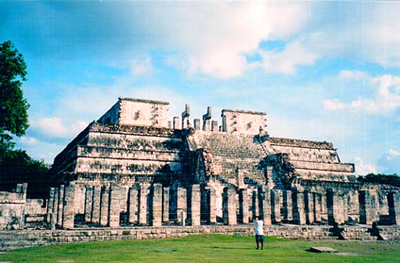
Needless to say, my journey to the north of Guatemala was not in order to see Flores but rather to visit a point some 40 miles further – the place called “Tikal.”
The next day I would be spending the entire day in “the capital city of the Maya”. To be prepared for this, I read the text I had brought with me. Since I was not planning to take a guide, I needed to know as much as possible of what had been published about it, so that I could devote myself to the walls of the city and to getting the feel of the place.
In the information from the American Consulate they warn of occasional attacks on tourists both on the way to Tikal and in the park itself. “The tourist police who patrol within the archeological park have significantly cut down on the number of criminal incidents but complete security has not yet been achieved. Most attacks occur in isolated areas away from the main square, such as Temple No.6.” (As it happened, this was the first part of the ruins which I was to visit the next morning.)
The translation of “Tikal” is “city of voices.» Since I had learned to be skeptical of everything, because the truth is usually to be found somewhere else, I asked myself where this name could have come from. Perhaps the voices are those of all the animals which inhabit the jungle surrounding Tikal: jaguar, monkeys, tropical birds, crocodiles, raccoon, deer…
In the
pictoglyph representing Tikal I look for “voices”: there are no pictures of
animals. The pictoglyph consists of four smaller and one larger picture symbol.
In the larger one
there are hands in a friendly handshake (at least that is how I would interpret
it) with three semi-circles above and ten dashes or short lines below. The
others are symbols: stars, semi-circles, dashes, parallel lines, etc. It is
clear that each represented a process; what exactly still remains a secret.
In 1979 UNESCO declared Tikal a “Monument of World Heritage.” It is thus recognized as one of the most important cultural and natural reserves in the world.
It is believed that Tikal was built around 800 B.C. and that it was inhabited for the next 1,700 years. This grandiose city was clearly exceedingly important to the Maya as a “religious, scientific, and political center” (as the archeologists like to say). Within some 40 square miles there have been found some 4000 large buildings: from temples and pyramids to squares, administrative buildings and warehouses.
The population of Tikal numbered as many as 50,000 during “the classical period.” It is believed that at that time (1500 years ago) there were a total of three million Mayans and that, if any city was the “capital” it was Tikal.
According to the history books Tikal was exposed to the Mexican Teotihuacán. Their warriors appear together with the Mayan leaders in stone carvings and three smaller pyramids were built in the Teotihuacán style.
Excavations at a depth of ten meters uncover the history of Tikal from the period before 200 B.C.
After this come the usual statements that the Maya did not have metal tools, draft animals, or the wheel.
(In conversation with the archeologist in Houston, I introduced the problem of the building of colossal structures without tools and without the known means of transport. She responded, “But these ancient people did not have television, so they had plenty of time.”
I said, “We can have as much time as you like but if something weighs 500 tons we will not be
successful in moving it if we try 10 or 100 times.” After this exchange the subject was changed.)
Beneath the major pyramids and temples of Tikal the ruins of older buildings have been found. And beneath them still older ruins create the effect of the many layers of an onion. Every few decades saw an awakening of further building.
This architectural boom of Tikal lasted until the 9th century A.D. Then, mysteriously, the city was abandoned. Overnight. The stone blocks began with time to crumble. The jungle moved in to occupy the palaces and temples.
Time stood still.
Tikal, northern Guatemala
The sleeping town of Flores awakens at dawn. Before Sunrise I am in a van headed for Tikal. We leave Peten Itza Lake behind us. The forest road passes through the greenery as if through tunnels and… finally we are there. After hearing so much about the famous ruins of Tikal, after seeing pictures of the Temple of the Giant Jaguar on tourism posters, after reading so much about this Mayan center, it seems like you know exactly what to expect.
But all those expectations are overturned the moment you set off along the jungle paths and begin to discover at every turn some new wonder. I crisscrossed the 25 square kilometers and climbed to the top of every temple, pyramid and palace. And still found enough time to sit, to touch the stone, to go back into the past and try to call up scenes of the visit of the cosmic Maya.
Here is an imaginary conversation between a man of the 21st century and a Mayan:
21st c. man: One thing I can’t figure out…
Mayan: What’s that?
21st c. man: How is it that you didn’t develop tools and technology?
Mayan: Do you think that wisdom and love come from tools? But I do understand your dilemma. In your world the organs and senses are less perceptive… so you make up for it with your tools and technology. But remember this – that in no way makes you superior. To the contrary.
I am constantly aware of scenes which are variations on this theme. Wisdom does not come from technology. And does technology come as a consequence of wisdom? Or does technology lull us into believing that we have achieved a very high level… when in fact we are only limited by it in our thinking – prevented from developing our mental capacities?
For me the answer is obvious. I would describe technology as material extensions of our body and our senses (think of the automobile, the computer, the telescope). And what we call history, or the history of progress, is in fact reduced to the history of technology. And then we equate this with civilization.
According to our standards, a society full of material comfort is an advanced civilization.
But we should ask ourselves whether technological advancement develops true creativity in man or his spiritual advancement.
Is it possible that all the tools and equipment and gadgets that we surround ourselves with are, in fact, limiting our frequencies and blocking our perception… not allowing us to receive new information from the cosmos?
Stone blocks have been mysteriously “transported through the air” and built into magnificent structures in Guatemala, Peru, Egypt, and Tibet. Songs and musical instruments have created frequencies which changed the face of the Planet. The aborigines of Australia, the residents of Atlantis, the Tibetans or the Maya knew that stone, and the Earth and the Sun are living organisms.
They come from a pre-historic era and, at the same time, from a pre-technological era. The age in which we now live is known as the “historical” era or the “technological” era. What awaits us (if we are fortunate) could be known as the “post-historic” or “post-technological “era.
A return to our mental capabilities.
(Of course there is also the possibility of a super-technological era such as destroyed Atlantis. This in the event that man is destroyed by the uncontrolled development of technology).
********
The subdued beauty of Tikal does not deceive me. Magnificent buildings are hidden by layers of Earth and overgrowth of plants; the ruts of trees which are hundreds of years old cover the stone stairways. Moisture has permeated the once perfectly carved stone blocks.
But the cold stone of Tikal emanates peace and harmony with the environment. The green overgrowth, the somewhat swampy soil, and the missing bridges which once connected things do not manage to hide the fact that this city, at one time the greatest of all Mayan cities, was a gem of great magnitude with its awesome buildings, lakes, and stone bridges.
********
“Temple No.4 west of the Great Square, is 320 feet high. This makes it the tallest structure built by the Indians in South America” overhear a guide telling a group of tourists.
“The difference between the pyramids and these temples is that the pyramids have all four sides the same, where us the temples have a front side with an entrance which is different.” Another observation overheard.
“The pyramids were built in accordance with north, south, east and west…” or “The Mayans feared the coming of the year 2012 which they believed would bring the end of the world.”
Guides shape the thinking of the tourists, sometimes providing useful information and sometimes, without realizing it, misleading them completely.
********
The road going towards the eastern edge of Tikal is deserted. The silence is broken only by my footsteps… and the thud of fruit falling from the ancient trees. Suddenly I feel that this fruit, which looks like wild chestnuts, is falling only around me. I stop. One, two, three… the nut-like projectiles come with force from the tree tops. I look up and see the silhouette of a monkey. Another one next to him, and yet another. Three rascals, using their tails to grasp the branch, are deliberately targeting me. A close encounter of the third kind. Fortunately their aim is not very accurate.
My visit to the first stone temples fills me with awe. A city lost in time. The elegance of the squares. The perfectly shaped corners of the blocks. Stairways after stairways. Platforms at the top. Narrow hallways, small rooms and passageways aimed towards the sky.
The most imposing structure of Tikal is the so-called “Temple No 4” – the tallest of the city’s buildings. It is about 320 feet high – the equivalent of about 40 stories. The foundation is estimated to be another 50 feet beneath the ground level. The stairways and walls have been taken over by the forest so that only the upper part sticks out, untouched. Wooden stairs have been built along the sides so that visitors may climb to the top. When one finally reaches the top the view takes one’s breath away. For tens of miles in every direction an unobstructed view of the jungle from above the tree-tops, and nothing else except the tips of other temples and pyramids of Tikal.
A powerful symbolism is felt at this windy location. Looking down, the human figures seem like tiny insects. All around is the powerful jungle above which the Maya raised their edifices. For those looking from the Earth’s surface, we are standing between the Earth and the sky.
I come to the main square and enter the Acropolis. The architecture there makes one feel that one is on a different planet. Layered stone structures, it seemed impossible that anyone could ever have lived there. In the middle are Temples No. 1 and 2, better known as the Temple of the Giant Jaguar and the Temple of Masks. Facing each other they silently communicate. I recall the view from the peaks of these two temples above the tree-tops. The gigantic stone slabs, with openings situated among them, had precise cosmic purposes.
********
My visit to the buildings of the Maya left me convinced that the Maya were indeed Cosmic travelers. Not astronauts as we conceive of them. Their perception of life and of cosmic processes was much deeper than that.
The Maya were informed about the Cosmos. Wherever they went they carried this information with them. Throughout the planets they were able to establish a two-way flow of galactic information.
And this was
not all. For the Maya everything was intelligent energy: the Cosmos, the Sun, a
piece of quartz, an ant or a man. Everything is alive. Everything has its own
frequency. Everything is information. And information moves. Intelligent information,
such as human beings, have the
possibility of transporting their information from one part of the Galaxy to
another. Cosmic travel was, for the Maya, the movement of information.
For the moving of information there is no need for space ships, rocket fuel and speed greater than the speed of light. The only thing needed is knowledge of cosmic frequencies.
Try to imagine the Maya on the peak of the Temple of the Giant Jaguar as they prepare in the evening at the proper opening in the stone for their travel to a different solar system. The instantaneous material disintegration, the transfer of “information” from the temple to another part of the Galaxy. At Tikal the ordinary folk who were witnesses to this cosmic traveling began legends of gods who come and go via the sky through the power of their thoughts.
The open parts of the temples and pyramids served as cosmic platforms for the Mayas travels through the galaxy.
In the 9th century something occurs which is an enigma for historians and archeologists. One after another all leading centers of the Maya are abandoned. There is no evidence of destruction in war, of battles, diseases, fires, or natural cataclysms. It is as if these cities were simply abandoned overnight, on command, without disorder or chaos. The farmers from outside the towns were left baffled. There were no leaders left. The cosmic civilization of the Maya had simply and mysteriously vanished.
Their mission on our Planet had been accomplished.
There remained carved in stone a vast number of dates of cosmic events and information related to astronomy … for those who would come in the future.
********
It is true that with the abandonment of Tikal in Guatemala, Copan in Honduras, and Palenque in Mexico (where my travels are later to take me) what is considered the Maya civilization did not come to an end. The “classical Period” had ended and the post classic period had begun, with centers in the Yucatan of Mexico. In the mixture of what historians call the civilization of the Toltecs and the Maya we also get magnificent architectural achievements at Uxmal and Chichen-Itza. But whereas the classical Maya were apolitical, this new era is marked by wars and human sacrifices, and knowledge of astronomy is completely neglected.
What was left after the departure of the real Maya were the occasional keepers of knowledge and magic, magicians and some who knew the ancient traditions – those who managed to keep alive the knowledge, codes and information, and lines of Truth which lead directly to the stars.
********
At the time of our birth, from our first cry, our journey begins into the mystery of the unknown. And at the end of our life it would seem that we know less than at the beginning.
It may seem to us that we have nothing in common with the Maya, the cosmic travelers. Even that we have no physical similarity with the bodies which they inhabited; the physical characteristic of the Indians of South America are quite different.
But it is in our future that we will, with time, become planetary Maya.
That we will adopt and develop their brilliantly simple and sophisticated technology which harmonically connects the frequency of the Sun and our psyche. That we shall create clean planetary technology and live comfortably in smaller groups… exposed to the flow of cosmic information. And a galactic light will enlighten us and all our mysteries and enable us to arrive at all the answers.
The Cholula Pyramid – a Copy of a Volcano
Cholula, Puebla, Mexico
I am landing again at Mexico City. Air Mexico is arriving on time-at 3:30 p.m. At the airport I purchase a new map for the roads of Mexico. I also discover there is a bus which goes directly to the town of Puebla. At the terminal exit I ask where this bus stop is. The policemen point it out to me. Almost instantly a young man comes up to me and tells me that the bus leaves from gate 5; the ticket costs 120 pesos, the trip takes two hours; and that I have 5 minutes before the next bus arrives.
I look at him and smile.
We get acquainted. He comes from Spain. His girl-friend is returning from Puebla on this bus, and that’s how he knows all this information.
The trip in the luxurious bus took exactly two hours. At the station I transferred to the local bus for Cholula.
Cholula today is a forgotten suburb of the city of Puebla which has a population of two million. Once upon a time this colonial town was the ancient center of a brilliant civilization with the largest pyramids ever built.
********
Cholula means ”the city of those who have departed.” Who are “they”? And where did they go?
The name was given by the Indians who were here when the Spanish “conquistadores” arrived.
********
Hernan Cortez was 33 years old. In 1519 he departed Cuba, with his 400 troops, cannons and cavalry, to begin his conquest of the empire of the Aztecs. They landed on the east coast of what is now Mexico, at Veracruz. From there he headed west, taking city after city, to complete the conquest with the fall of the capital city of Tenochtitlan (today’s Mexico City) and the killing of their leader, Monteczuma.
At about the
halfway point they encountered Cholula which Cortez describes as follows: “a
large city of 20,000 houses and a population of some 100,000. It is also a religious
center with over 360 temples. (Hammond Innes, “The Conquistadors”, Alfred
Knopf, New York 1969)
He goes on to say: “The city has its own government and is not beholden to
anyone. The land is fertile and irrigated. This is the most beautiful city outside
of Spain in its architectural and natural beauties.”
Upon entering Cholula, Cortez learned of the trap which was being set for him by the Aztecs. He beat them to the draw by the execution of their military leaders, followed by a massacre of 6,000 Indians.
********
My first night in a decent hotel in the center was not a peaceful one. It was as if the screams of thousands of massacred Indians could still be heard and the sharp features of their faces could be touched in the semi-darkness.
********
On either side of Cholula there are two gigantic volcanoes – Popocatepetl (17,833 feet) and Iztaccihuatl (17,388 feet). The ruins of stone structures (temples) are found on both volcanoes, which are therefore considered “sacred mountains.”
The names of the volcanoes come from the Aztecs – the last civilization in Mexico prior to the arrival of the Spaniards. In the Nahuatl language “Popocatepetl” means “the mountain which smokes”, and Iztaccihuatl means “the sleeping white beauty”, There is a romantic legend which tells of the love between a great warrior and the king’s daughter. The warrior asked for her hand in marriage and the king agreed to it provided that the warrior succeeds in conquering a neighboring tribe. The warrior sets off on his task but it takes longer than expected. In the meantime rumors circulate that he has been killed. The king’s daughter dies from grief. When the warrior returns he carries her body to the top of the mountain to be interred there forever. (The west side of the mountain can be seen to have the shape of a sleeping woman.) The warrior, overcome with grief, climbs to the other peak and carries his torch with him, so that he can eternally keep watch over his lost love.
The “torch” gives off smoke constantly, a reminder of the fact that this is a “live” volcano with all the attached dangers. Being a clear day, it was possible to see the white smoke which was steadily pouring out of the top of the volcano.
It has been written that Moctezuma sent ten of his best warriors to discover the source of his mysterious smoke. They were followed by some of Cortez’s soldiers, making them the first white men who succeeded in climbing the tallest peak known at that time.
********
Archeological research indicates that around the year 1700 B.C. two settlements grew to become one, creating a city which was continuously occupied for the next 3700 years. It is believed that work began on the Great Pyramid about 100 B.C. when Cholula became an important regional center.
It is supposed that Cholula was, in its wealth, a reflection of the pompous Teotihuacan; the colossal buildings, made with the same style, during the same period of development (100 B.C. to the 9th century A.D.) and sharing the same time of their downfall (900 A.D.). And as with Teotihuacan, after a few centuries of abandonment, these cities were again occupied by the Indians from the north (the Olmecs, the Tolteca-Chichimeca, and the Aztecs) to be ultimately swept from the stage of history by the Spaniards.
********
My first nighttime walk was in the direction of the Tepanapa Pyramid. A few directional markers led me to a forest-covered hill. To the right was a well-lit path leading to a church at the top of the hill. I, of course took the fork to the left. After another hundred yards, there was another path leading up the hill – this time with a gate. I came closer. At that moment, a nun was coming out of the yard. I immediately knew what order this was.
A hundred years ago at this location work began on the building of a psychiatric hospital (asylum). At that time, in the year 1910, they discovered the ruins of much older stone buildings. Another twenty years or so were to pass before the first phase of excavation (1931-1956) was begun. Two tunnels were dug (one north-south and one east-west), with a total of five miles in length, in order to establish the extent of the stone structure. The archeologist Ignacio Marquina relied upon his experience in the excavation of Teotihuacan. The conclusions were shocking – they had discovered the largest structure ever built on Mexican soil. He had proven the existence of a pyramid with sides of nearly 500 yards in length and a height of over 70 yards. This was larger than the Cheops Pyramid in Egypt and the Pyramid of the Sun at Teotihuacan.
The model shown in photo shows the probable appearance of the pyramid and the structures which went with it.
The tunnels through the pyramid are lit and have not been changed significantly over the past 60 years. Of course, I could not resist walking the five miles of those narrow corridors.
The second phase of investigation (1965-1972) was focused on analysis of the artifacts which had been found. This showed that the pyramid had been constantly visited by various cultures, having been considered the center of all happenings.
However, the pyramid has never been completely excavated. Only a very small part of it. The reason? – the opposition of the church. “Further excavation could lead to the collapse of the church.”
********
After the bloody massacre carried out by Cortez, he issued the order that more than 360 temple pyramids should be leveled. (Some sources give the number as 365 – one for each day of the year; others say 400 – a number which I am more prepared to give credence, because 400 was a sacred number for the Maya). On these foundations Cortez promised “to erect an identical number of Catholic churches.”
The temples of the “infidel” Indians were destroyed. But the vow to build an equal number of churches was never to be completely fulfilled. Of the original 70 churches which were built, only 39 are still standing (and most of them are in sad condition).
It is interesting that the largest church was built on the only hill which rises in the area of Cholula. It took another 400 years to discover that this hill was, in fact, the largest pyramid of Cholula which the Spaniards knew nothing about.
A legend which the locals like to tell the tourists is that the residents of Cholula, knowing that Cortez was headed their way, buried the pyramid so the Spaniards would not destroy it. Unfortunately, this romantic tale has no basis in fact: the pyramid had been covered by thick forest hundreds of years before the appearance of the Spaniards. At that time it had already been completely forgotten and was unknown to the Indians of that era.
Shortly after conquering Cholula, the Spaniards erected a giant cross on the peak of the hill. That same year it was broken in half by a lightning strike. The Spaniards erected a new one which “somehow” met the same fate. After that they built the first church (Santuario los) at 75 meters above ground level. Over the next centuries the church was destroyed three times – from earthquakes or lightning strikes-most recently in 2001. However, the Catholic priesthood continues to hold that the church belongs at the top of the pyramid and persists in its renovation. At the time of my visit the smell of fresh paint was unmistakable.
But the superior construction of the pyramid has been resistant to earthquakes for well over a thousand years. The original builders used a special design (the so-called “tablero” – an inverted capital ”T”) which contributed to the strength and longevity of the walls.
********
As we were walking through the tunnels, the guide, Porfirio, told me of chronology of the excavation effort, the levels of the pyramid, and of altars and sacrifices. We go out into the open and he stops and points out to me the peculiar auditory effects that these stone structures have.
After listening patiently to what he had to say, on several occasions we had the following dialog:
“The stairways led to the foundations of the pyramid…” he says pointing to the base of the staircase from the tunnel.
“So from there one could go out to the lake?” I ask.
“The lake?” he responds, bewildered.
“Yes. The pyramid was originally built at the edge of a small lake,” I explain.
He makes no response.
********
“The altars were apparently used for sacrificial ceremonies,” Porfirio says.
“Have you heard that the altars in fact had the function of harmonizing the vibration of the Earth with the Sun?”
Once again, he makes no response.
********
“Porfirio, if you had the power, what would you do with this park and pyramid?” I ask this guide, whom I have taken a liking to.
He thinks about it a bit, amd then he says, “I would strengthen the supports in the tunnels and cut down on the number of tourists.”
“You know what I would do?” I tell him. “I would get rid of the church on the top of it and I would completely renovate the pyramid.”
He smiles.
********
Of the murals and pictures on the walls not much is left. But the one on the wall which shows “a party with drink” (and which is still unexplained) seems to me like a precursor to four-dimensional cubism.
********
This return visit to Mexico has left me with a feeling of the inferiority of the civilization to which I belong. We have these colossal buildings with an earthquake resistant design. We have pictoglyphs which we cannot decipher. We have a culture about which we know almost nothing. Who? When? and Why? And a disappearance which coincides with the disappearance of the Maya (southeast of here) and a population of half a million at Teotihuacan (northwest of here).
Cholula poses new questions.
The Magnificent Monte Alban
Monte Alban, Oaxaca, Mexico
The Puebla-Oaxaca highway, in a comfortable bus, four and a half hours’ journey. We are headed southeast toward the archeological jewels of Monte Alban and Mitla.
How many different civilization have considered Mexico their homeland? and how many have disappeared forever leaving us without the chance of learning from their achievements and their failures?
The route that we today are traveling was taken earlier by others. And not by just a single civilization.
********
From Oaxaca to Monte Alban is a mere eight miles. A local bus takes you there for $3. A tourist bus will charge you $30. I managed to find the local bus station to catch the bus (which didn’t look like much) and in half an hour we had climbed along the narrow winding road which led to an elevated flatland overlooking the valley.
The magic of Monte Alban begins with its size. It is officially proclaimed to be the second largest ceremonial center in Mexico after Teotihuacan.
The location of this architectural complex is a mountain peak which has been perfectly leveled, similar to the plateau for the pyramids at Ghiza. Of course we are once again told that this was done without the help of the wheel, draft animals or metal tools. Fifty-five acres of land (eight times the area of the Vatican in Rome) is the extent of this space.
We are confronted with the mystery of the stone blocks and slabs, each weighing tens of tons-how were they transported several thousand years ago?
Then we have the hieroglyphics which still today are mostly undeciphered. They can be seen to originate from the same source as the Mayan, 300 miles to the east.
Here we also have original stone blocks, as old as this “city”, which on all four sides show carved faces with Negroid anthropological features. The attempts to interpret them have given feeble results: some refer to them as dancers and others as slaves or prisoners. Only when we manage to decipher the texts will we be able to know what these figures represent.
The location of the Monte Alban pyramids corresponds perfectly to a north-south axis. The single exception to this is a structure known as the astronomy observatory which has the shape of an arrow and is positioned at a 45-degree angle. The observatory is pointed toward the star Alnilam – the central star of Orion’s belt.
Conventional archeological theory is at a loss to explain Monte Alban. Why was this location chosen for such a building site? All approaches to it are very steep, even dangerous for climbing. There is no source of water. It was never used for residence. There is no military use for it. The building material used for the construction of these magnificent pyramids is not located anywhere nearby.
********
“Monte Alban” is the Spanish for “White Mountain.” The earliest use of this name dates from the 17th century when the Spaniards had seized control of this territory. The ancient name for this center is “Sahandevui” - “at the foot of the heavens.” This is perfectly appropriate. It has a commanding position above three valleys. And the blue sky seems to be within easy reach.
The Mixtecs called it “Yucucui” – “Green Peak” and the Zapotecs before them called it “the Mountain of Sacred Buildings.”
********
At the entrance to Monte Alban there are a few guides offering their services. I am not of interest to them since I am alone – they prefer groups who will pay them more. I start up a conversation with a few of them. I put out a question which I know they won’t be able to answer: “Who built the original structures here?”
I pick up information as I tour the site. I notice two people carefully examining one earthen terrace. I suppose that they are part of Richard Blanton’s team from Purdue University which is currently researching this location. Over the last eight years tens of thousand of stone tools, ceramic dishes and statues have been found. Thus far, 2100 terraces have been identified and some 30,000 maps have been made. A data-base has been created on the life of various cultures from 1500 B.C. until 1521 A.D. and the arrival of the Spaniards. Bones of earlier migrants indicate that there were humans here more than 15,000 years ago.
The first serious archeological research here was done by Dr. Alfonso Caso in the period of 1931-1953. His conclusions still dominate the literature: first, that the Zopotecs built Monte Alban about 500 B.C. and second, that it was abandoned in the beginning of the 10th century A.D. and settled again by the Mixtecs 200 years later.
Stephen Kowalewski of the University of Georgia estimates that about 500 people lived in the valley around 1500 B.C. By 500 B.C. the number had reached 5,000. In another 300 years, the number leapt to more than 40,000. Over the next thousand years, the population swelled to 60,000-making it one of the most significant centers of the region.
The mysterious abandonment of Monte Alban at the beginning of the year 900 A.D. is clearly connected with the disappearance of the Maya.
It is time that we should correct the official historical data to recognize that all of these cultures from Teotihuacan (north of Mexico City) and 2000 miles to the east-in the Yucatan and another 600 miles to the south (Guatemala, Belize, Honduras, El Salvador) all belong to one civilization. They have the same writing system, knowledge of astronomy, architectural achievements, spiritual life…
After so many years of research, Richard Blanton admits: “We really do not know why or when Monte Alban was built.”
He goes on to say: “Perhaps we will find out more when we manage to decipher the hieroglyphics on the stone blocks known as “Danzante” (the dancers) – the oldest written text in the Americas.
********
This impressive complex contains a message for our civilization.
We can draw a parallel between the technological and developmental boom of our two civilizations; wars and conquest; but note our spiritual inferiority. Was their disappearance (from this dimension) voluntary? Is the cataclysm awaiting us inevitable?
********
The plateau is peaceful and quiet. Occasionally a guide will clap and the echo can be heard everywhere around. I climb to the top of the pyramid. An impressive view lies below me: three valleys with the city of Oaxaca at 1700 yards above mean sea level. Monte Alban is 500 yards above that. The pyramid puts me another 50 yards closer to the sky.
As always, it is windy at the peak of the pyramid. There is no shelter and no let-up. You are exposed to the weather which warns you of your frailty beneath the heavens.
Below me there is a mixing of the distant and the recent past. After the mysterious founders of this center there followed the rise and fall of a whole series of cultures. Below the main part of town there were built less imposing houses where ordinary people lived. Most of their lives they spent cultivating the small garden terraces, climbing and descending the slopes of Monte Alban. They carried water, fruit and vegetables, fish, jewelry, decorations, tools, ceramics and textiles. They celebrated and buried their priests and rulers. In a later period they witnessed sacrificial and other complex ceremonies and rituals.
The sacrosanct nature of the city was violated long ago as the religious rulers pushed to have their bodies buried next to the pyramids and temples, believing that this would enable them to be forever close to the sky or “the heavens.” Hundreds of burial spots under the ground were scattered about the plateau of Monte Alban. And hundreds of grave robbers soon carted off the earthly treasures which had been interred with the bodies.
Primitive customs of sacrifices and appeals to the gods are maintained even in the present day. According to reports of Blanton, one day “we came across a hole which had been dug a few days earlier in which an offering of a turkey (with its head cut off) had been made to the gods together with a few cigarettes.”
********
For three thousand years Monte Alban maintained close connections with the other elite super centers of the region such as Teotihuacan, Cholula, Palenque, Tikal and Copan. Stone pyramids decorated with murals rose to the heavens throughout Central America.
And then, suddenly, in about the year 900 A.D., these sophisticated cities were abandoned. The population disappeared. The jungle began to swallow up the white stone.
Several hundred years passed before primitive Indian tribes from the north moved in to settle these abandoned cities. And another couple of hundred years before the arrival of the European conquerors.
********
The enigma of the choice of Monte Alban as the location for building has an answer. The mountain that this complex is resting on is an energy potent point. Energetic lines can be found with divining rods. Usually several such lines cross at the places where pyramids and temples have been built.
After the founders of Monte Alban found this energy location, they began the building of the first structures. Electrically and magnetically potent points enabled attainment of the desired spiritual level.
With the passage of centuries and millennia, at the places of early spiritual centers temples and pyramids were built. Architecturally perfected, they elicited awe and wonder by their external appearance. The memory of the original inhabitants faded and in time was completely lost.
By extension of the original buildings complex ceremonial centers were created. And various religious methods were practiced within them, including sacrifices.
But these later phenomena had nothing in common with the creators of this and other centers. The original function of Monte Alban was forever forgotten.
And the archeological ruins became modern tourist centers.
Mitla, Oaxaca, Mexico
The city of half a million which is Oaxaca at first glance is no different from most other cities of Mexico. Single-storey gray suburbs, heavy traffic. I set out from the bus station in search of lodgings in the center of town.
The side streets seem somehow more appealing. An unusual greenish volcanic rock has been used in many of the buildings.
Others have been painted turquoise or lavender. Along with this there is a recognizable baroque architecture. Two unusually large parks and here I am in the center of town, known as the “Zokalo”
Five hundred years ago (in 1526) the Spaniards encountered a fortress of the Aztecs which was only about 40 years old. It is supposed that it was built on the foundations of a much older city. The leading architect of the kingdom, Garcia Bravo, who also planned Mexico City and Vera Cruz, was brought to Oaxaca. With string and chalk he marked off north, south, east and west; the building of the “Zokalo” (square) was begun. The Cathedral was built on one side of town (on an Aztec burial ground) and the Governor’s Palace on the other. This was the traditional Hispanic way of symbolizing “the balance between the earthly and spiritual powers.”
Cortez was so fond of this town that the king declared him “the Marquis of Oaxaca Valley.” His distant cousin, Gonzalo de las Casas, set about in 1546, with a work force of more than 6000 Indians, to build houses for the next 25 years with Baroque architecture, creating a colonial charm nestled into this valley which outdoes anything else in Mexico. It therefore comes as no surprise that UNESCO declared the entire city a protected part of the World’s heritage.
It is Saturday afternoon. The center is closed to traffic. The many street vendors, thousands of balloons, music, children, tourists, Indians, white, yellow, black – all mixing in these few square miles. I’m still looking for lodging. The better hotels are too expensive, the less expensive ones are all full.
I don’t mind the walking – it gives me a chance to get to know the city. This is the home town of two of the best known Mexican presidents. Benito Juarez was a Zapotec Indian without a formal education. He became governor and head of state (1858-1872). He defeated the French army and removed the Austrian archduke, Maximilian, from the throne. In the eyes of the people he became a mythical character and national hero. Every town has a street named after him, or a monument, or the university.
The story of Porfirio Diaz is different. This Mixtec Indian built a military career which enabled him to establish a long-term dictatorship (1876-1910). Although he opened up the country to foreign investment, the great majority of the population remained poor. He left the country at the time of
the Revolution of 1910. The last years of his life he spent in Paris, living with his memories, hating French food and remembering the colors and smells of Oaxaca.
Finally I found myself a simple youth hostel. Its owners were very pleasant people. I tell them about what I want to see. They give me advice on how to get the most for my money.
I pass by the Dominican church of Santa Catalina. This is where Juan de Cordoba spent 25 of his 100-year-long life. They say that throughout his entire life he never touched money. He put on sandals only for the time of mass. He spent his life in meditation and in compiling a dictionary of the Zapotec language. Even today the Indians revere him as a saint.
The writer D.H Lawrence lived here for several years. The philosopher Nitsche wanted to do the same. John Lennon descended into the nearby caves, wanting to go as deep as possible into the center of the earth. Elliot Weinberger (the translator of Octavio Paz) announced that the Zokalo was “the perfect place to do nothing.”
And he was right. I sit down on the wrought iron bench on the main square. It is Saturday evening and everyone is dressed in their most beautiful and colorful outfits. The restaurants, galleries, and cafes are full of people sitting, talking and singing. The sound of guitars and tambourines fills the air. On the park bench next to me a mother is feeding her son. He looks at me with his big dark eyes-at first shyly and then with a big smile. In the center of the park there is a bandstand which seems to have been left from Austria a hundred years ago, where concerts are held three times a week. That evening was the first time I felt really comfortable in a colonial Hispanic town. There was no smell of the military domination of the Conquistadores. Oaxaca was not on Cortez’s route of conquest but it had surrendered before Moctezuma’s defeat. There is no evidence of destruction of the ancient pyramids and temples (only of the Aztec fortress). But there is instead the wealth of various cultures and races living together in peaceful coexistence which lends a particular charm to this city.
According to a Mixtec saying, “A healthy person is one who lives happily and in peace.” The magic of the Zokalo and the Saturday fiesta (and several hours on Sunday afternoon) provided moments which I spent as “a healthy person.”
********
How old is civilization? The residents of the small town of Santa Maria del Tule (east of Oaxaca) say that it is as old as their “ahuehuete” or “Tree of Tule” (Arbol del Tule).
The oldest tree in the world is located in the center of this small town, in the churchyard – it is a cypress over two thousand years old. It is 160 feet tall and 185 feet in its spread. It weighs 650 tons.
********
Another 30 miles journey by van brought me to the archeological site of Mitla. The translation of the name of this place is the same, whether we are talking about the Spanish name “Mitla”, its name in the Aztec Nahuatl language “Nictlan”, and the Zapotec language “Lyobaa.” The meaning is “the Place of the Dead.”
This place has been inhabited for all of its 3,000 years of existence. Archeological findings trace it back as far as 900 B.C. but cannot tell us about the origins of those who built this sacred place.
The culture of the Zapotec Indians left visible remains of buildings erected between 200 and 900 A.D. After their disappearance around 1000 A.D. they are replaced by the Mixtecs. The Zapotecs return in 1200 A.D. The Aztecs after several attempts finally enter this place in 1494. Only twenty years later the arrival of the Spanish brings an end to the story.
Mitla was not taken over by the jungle like most of the other cities of the Maya. Because of this the walls, decorations, and even colors on the wall have remained more intact in certain places. Particularly impressive is the red color of the façade which survives after more than a thousand years, despite being exposed to the elements. The walls of the palace have 100,000 unique decorated stone squares and rhombs formed by, and filled with, geometric figures.
In contrast to the vast majority of ancient buildings here there are no zoomorphic or anthropo-morphic representations. Instead, abstract geometric forms introduce a new element in spirituality and art. I wondered as I looked at them whether they were stylized representations of the god, Quetzaqoatl, the sea, the transitory nature of things, or whether they just had a special visual effect which enables or contributes to making it easier to achieve the desired spiritual level.
I continue to examine them carefully. The stone mosaics were carefully polished and perfectly inlaid into walls more than a meter thick. No adhesive material had been used. Magnificent craftsmanship!
Inside the palace is the so-called “Courtyard of Pillars.” Six impressive monolithic stone pillars of volcanic rock were once the support for the roof of this building.
From the 130-feet long “Courtyard of Pillars” one enters a new chamber which is the greatest mystery of Mitla. The walls are covered with panels of stone mosaics. Archeologists are at a loss to explain the purpose of this room.
The only written evidence we have is from the Spanish conquerors and is related to the last users – the Zapotecs. In 1580 Canseco wrote this description: “In this building they had their idols and they gathered here for religious ceremonies. They carried out rites of sacrifice to their gods and other religious ceremonies. Their high priest – the equivalent of our Pope – lived in the residence.”
The oldest and therefore most significant piece of information we have is the legend which states that this chamber was earlier used for the final phase of the initiation rites of the “shamans” who were trained in magic and healing.
Using divining rods, evidence has been found of greater-than-usual energy activity in this rock. There are certain authors who claim that this chamber was a portal between spiritual dimensions.
I leave the palace and head south to the next small plaza. There are ruins of walls with impressive stone thresholds above the entrances. The carved stone lintels each weigh in the neighborhood of twenty tons. At their base there is an underground passage which leads to the tombs. I use the improvised steps to go down there. There are more geometric mosaics on the wall. The tombs are empty. They had already been robbed centuries before the arrival of the Spaniards. I take a few minutes’ rest in one before continuing on.
The circular support column inside the tomb area has several myths or superstitions connected with it. According to legend, if one wraps ones arms around this stone megalith:
1. The distance between your hands indicates how many years of life you have left (one finger width for each year remaining);
2. If the column moves, death will strike immediately;
3. Hugging the column contributes to fertility.
I couldn’t resist the temptation to hug the column. I closed my eyes and listened. The column did not move. My fingers did not meet. As for fertility, I was not particularly concerned about that.
At sunset I depart from Mitla. “The Place of the Dead” had not always been a prestigious location for the tombs of the high priests.
********
This planet does not belong to us. Neither is it the possession of our grandchildren, as some would like us to think (“We have this Earth on loan from our grandchildren.”). In fact, it is the other way around. We belong to the Earth.
The original builders of Mitla were aware of this. They knew where the earth’s energy potential points were. And they built on this.
After their departure all that was left were the legends and lore, as well as conflicts of those who came afterward.
********
Once again I am in Oaxaca. I have supper at the Zokalo. A whole river of people are walking by, but there is a peacefulness in the air. I once again think about how nice it would be to live here. Two tables away I notice the pleasant face of a sixty-year-old-man. Gray hair, beard and mustache, pale blue shirt with a dark blue scarf around his neck. On a couple of occasions our eyes meet.
I pay the bill and walk past his table, and I nod in greeting. He says hello and invites me to join them at his table. He is with his wife. She has dark skin, her black hair is pulled back into a bun, and she has a nice smile. He introduces himself as “Felipe.” His wife is Mexican and he is from Wisconsin. He came here 25 years ago, and he stayed. “Felipe” was once known as “Philip.”
In the next 10 minutes, which was how much time I had till my bus departed, we covered Atlantis, Lemuria, the Maya and Peru, and the mysterious valley of Oaxaca.
He asked me whether I had read James Churchward, who wrote about the first human civilization, Lemuria.
As we parted, I said that every person we meet in our life has some message for us. He nodded in agreement. It took about 15 days for me to discover the message that he had given me. In returning to Churchward’s writing, I found a reference to the Maya. At that point I realized that I would conclude this book with the story of Lemuria.
At the bus station I get the last available seat on the bus for that evening. I have 14 hours of traveling ahead of me. From Oaxaca in the heart of Mexico towards the forested mixed-up land of Chiapas.
The Magical Palenque
Palenque, Chiapas, Mexico
As I am entering the state of Chiapas, I am reminded of the fact that this is the most turbulent region of Mexico; a military patrol inspects all cars, trucks and busses on the road. A revolutionary rebellion of the Indians was started by a “Commander Marcos” in early 1994. They took the name “Zapatistas” after Emilian Zapata, a hero of the 1910 revolution when the president, Porfirio Diaz, was forced to flee the country. At that time, agrarian reform was proclaimed which unfortunately has never been completely implemented. Generally widespread poverty once again forced the Indians to rise up and make themselves known.
“The Lord of the Night, Master of the Mountain, a Man without a Face”, Marcos is a modern rebel of the 21st century who publishes his manifestos on the Internet. He caused a sensation when with a hundred of his followers, he paraded on the streets of La Realidad in the mid-90s armed with rifles from the “antiquariat.” The Mexican army strengthened its numbers in the area after the Zapatistas expelled the first white ranchers from Chiapas. Today the mysterious Marcos heads a political movement which he hopes will spread through-out all of Mexico.
The entrance into Palenque is not impressive. A few hotels, houses of no particular attractiveness, workshops with a few tables put out in front. I leave my things in a damp hotel room, after having opened the windows to try to air it out. (I am at the hotel Avenida, in the “Economics Room”). I go out onto the street and catch the first mini-bus marked “Ruinas.”
On the way, I think about the name of the town. Santo Domingo de Palenque was founded in the 17th century (not counting the little church est.1573). It would have remained insignificant were it not for the discovery, in 1774, of the ruins of a great city of the Mayans. Antonio del Rio hurried to Guatemala to announce his discovery to the Royal Council. From that time there were research expeditions frequently setting out headed for this place. The ruins were given the name Palenque after the small town located nearby.
The most extensive excavation work was begun in 1920 by the Danish archeologist Frans Blom. In 1952 the place became a world famous archeological treasure with the discovery by Mexican archeologist Alberto Ruz, after years of moving tons of stone blocks, of the only tomb of a Mayan – the ruler Pacan Votan.
By that time more than 200 buildings of various sizes had been recovered from the jungle. And this was estimated to be barely 10% of the actual extent of this ancient city.
********
At the entrance to the park there are vendors of beverages, fruit, souvenirs, a tourist agency and “collectivos” – mini busses or vans. Three of the guards I notice are having a lively discussion, and I hear mention of “Zapata.” In passing, I remark, “Zapatista – subcomandante Marcos.” One of them winks at me and says, “Si! Bueno.” and gives me a “thumbs-up.”
Passing through a hundred yards of ancient forest, I come out into a clearing. On the flat plateau I see before me the first of buildings. The blackened damp stone witnesses to the millennia of existence of this center.
I recognize the pyramids, temples, the observatory… from photographs I have seen. And here they are in front of me. On the one hand I sense their grandeur, their artistic achievements, their intransience. On the other, their isolation, the silence, the absence of humankind. And all of that is framed within the Central American jungle, of an intensely green color.
********
This city, built more than two thousand years ago, connects the dragons of the Orient, dark-skinned African (Atlantidean?) faces, the Mayan writing system, staircases and pyramids with platforms turned to the Cosmos.
Communication at that time, despite our misconceptions, had no limitations.
This place is described variously as: “One of the largest Mayan cities”, “Mexico’s most impressive ruins”, “The most popular archeological park”, “a political center with inventive architecture and a highly developed trading system with distant Meso-American cities.”
The peak of power of the city corresponds to the time of its leader, lord Shield Pacal. Through partially deciphered hieroglyphs and pictoglyphs (Linda Schele and Peter Mathews) it was established that Pacal was born in 603 A.D. and came to the throne at the age of 12 (615A.D.) to rule until his death in 683 A.D. – nearly seven decades later. His most important building was the so-called Temple of Signs. This was also the place where his bones were laid to rest and remained undisturbed for 1300 years before this tomb was discovered and opened.
In 1949 the director of the Mexican Institute of Anthropology and History, Alberto Ruz, began research work on this city. He decided to focus upon the Temple of Signs because it was the largest building. He decided to try to discover a way into the temple from the top of the back side. He began by moving a huge stone block which was different in color from the other blocks. There followed three grueling years of moving blocks to discover a series of stairways. Then on July 13, 1952 they reached a triangular stone around which the skeletons of six young men were found. This was a reliable sign that these were human sacrifices or victims put to death in honor of a great leader. A great stone block was moved by half a meter and Ruz decided to have himself lowered by rope into the dark chamber.
“That was a moment of indescribable emotion for me… when I slid beneath the stone. I found myself in a large chamber which had been carved into the rock. There were stalactites which had formed from the water dropping from the roof for centuries. A huge stone tomb rested on six carved pedestals. The cover of the sarcophagus was decorated with hieroglyphics.”
Up until this point there had been no evidence found of a single pyramid in Mexico having been used as a tomb. Palenque became an exception.
When the cover of the sarcophagus was moved, the skeleton of Pacal was uncovered. On the skull there was found a mask of jade. In addition there were necklaces, rings, and images of the sun god made of jade, symbols of the Nine Lords of Time… all of this in a temple with nine ascending layers.
Of special significance is the cover of the sarcophagus showing the figure of a man (or human-like figure) sitting on a long object. (Another interpretation has it that the tree of life extends from his stomach). The pictoglyph represents a combination of organic, cosmic and technological things. The individual is either floating or flying. Daniken used this picture as final proof of his theory of interplanetary travel of the Maya (“an astronaut in a space ship”). Jose Arguelles, author of “The Mayan Factor” interprets the “tree of life” to be the Cosmic Center (Kuxan Suun).
On the stone cover two numbers are also carved: 12:60 and 13:20. The period from the making of this tomb until its discovery (1952) was exactly 1260 years. And the period from 692 A.D. until the end of the Mayan cycle (2012) is 1320 years. Is this pure coincidence? or was the creator of this tomb also endowed with the gift of prophesy and sending us yet another message?
Arguelles makes the following statements:
“Pacal Votan, lord of the galaxy, was declared by a serpent, to be the ruler of knowledge. By decree of those above him, Pacan was ordered to leave his land, the mysterious Valum Chivim, and to go to the Yucatan, the land of the Maya on Earth. Pacan landed near the river Usumacinta, near Palenque.”
The explanation of this story is as follows: the Valum Chivim mentioned in the Mayan hieroglyphics is one of the star bases of the Maya, probably in the Pleiades system (the star Arcturus?). These bases had the task of overseeing the mission of the Maya on Earth from the time that Galactic lords (“The Nine Lords of Time”) brought intelligent life to Earth. Pacal Votan was to oversee the final phase of the Mayan “Project Earth.”
Popul Vuh, the sacred book of the Maya, speaks of the mythical Xibalba, the underworld, in which “mortality is heroically tested.” More precisely, this is where the Maya assume a mortal human form. Xibalba is related to the ancient town of Xibalanque, which in modern translation is Palenque.
Does this mean that Pacal simply returned to Valum Chivim, his homeland in the stars after having successfully carried out his role on Earth?
On several of the stone reliefs we can see the transfer of power between Pacal and his mother. Although in size she is not as tall as he is (clearly for hierarchical reasons), one can notice she has much larger bones.
When I got back to Houston, I checked the scientific literature. The American archeologists Merle Greene Robertson had spent several decades studying Palenque. She points out that the portraits which show Pacal’s mother, Zac-Kuk, have abnormally enlarged jaws, significant circles under her eyes, emphasized eyebrows, and shovel-shaped hands… In short, distorted (extra-terrestrial?) physical characteristics.
Across the way from Pacal’s Temple there is another significant building. It is the Observatory or Wind Tower located in the middle of the palace complex. It had been established that its windows are located to align with the position of certain planets (Venus) and stars (Pleiades, the Sun and its solstices and equinoxes).
The palace is surrounded by three impressive temple pyramids: the temple of the Sun, of the Cross and of the Duke. The facades with their series of hieroglyphics describe gods and historic events tracing back thousands of years. This is dominated by an elaborate representation of the transition of the human soul into the realm of the dead, or the transformation of certain Mayan leaders into gods (or astronauts?).
The last date on the walls of Palenque corresponds to 835 A.D. After that this sacred center of the Maya was mysteriously abandoned. What became of these astronomers, priests and artists? Where did the Maya go in the middle of the 9th century?
********
The Temple of Signs is unique among the buildings of the Maya. The sarcophagus of Pacal, on the ground floor, was significantly wider than the passages and stairways leading to the chamber where it was located. This means the tomb was made first and then the impressive and extensive temple. This is yet another distinctive element. The name “Temple of Signs” was given it because of the series of 620 hieroglyphics – the longest in the Mayan world. Last of all, the skeleton found in the tomb of Pacal is unusual – he was significantly taller than the average Mayan. The age of the person at the time of death was established to be about 40 years. According to the hieroglyphs at that sacred location, Pacal died at a ripe old age of 80. Who is it then who was buried here?
Just when we start to think we have learned something about the Maya, what we uncover turns out to be yet another mystery.
********
If we could go back into the past and return to the year 810 A.D., if we could join the crowd of people on the square in front of the Temple of Signs, what might we witness happening at the top?
On the platform 13 men are seated, 13 Maya who are Lords of the Galaxy, keepers of knowledge. Each of them has a large quartz crystal in front of him. They are seated deep in meditation. Suddenly a dull vibration can be felt – it is part sound, part sight. Before our eyes we see a pod of light materialize. At first it hovers above the Lords of the Galaxy, then it begins slowly to surround them. Soon all 13 are inside a transparent ball of light. The noise and the vibration become louder. The frequency becomes higher. The people of the town have their eyes glued on the ball of light which is slowly beginning to fade. Soon the ball of light and the Maya in it have disappeared. The scene seems to turn into a dream. The vibration is no longer felt. The crowd of people slowly disperses.
********
In my search for an answer to what happened to the Maya in the 9th century I analyze what has been written by historians and archeologists. Famine, war, drought, earthquakes… none of these can be used to explain this massive and complex disappearance of an elite population.
War might explain the loss of a few cities. Drought would logically cause migration from the area where there was no rain. Earthquakes and natural disasters would cause a large number of fatalities but would leave evidence behind.
The Maya were living beside the sea, rivers and lakes, in valleys and on the mountainside, in both damp and dry regions, and their civilization had several thousand centers. Several thousand cities don’t just disappear overnight.
I search for other possibilities. We today have a neutron bomb which would kill people without destroying buildings. But we have no evidence that the Maya (or other people of that time) had such a weapon, and we have not discovered skeletons which would be left after use of such weapons.
So we must go further in our search for an answer.
Did the spiritual and intellectual leaders of the Maya abandon the Earth’s surface and, using secret tunnels, move down into the underground?
Or perhaps they moved into another dimension which is not visible to the human eye?
Or, were perhaps those who were ready picked up in spaceships by their mentors from the Pleiades star cluster?
Or perhaps they joined the Lords of the Galaxy and, in pods of light, set off on a journey with no return.
Yaxchilan
Yaxchilan, Chiapas, Mexico
Today I have scheduled a special archeological treat: the Mayan city of Yaxchilan in the southeast corner of Chiapas, on the Guatemalan border. The mini-bus from Palenque departs at six in the morning. We have 100 miles ahead of us to reach the river and border.
After a speedy (sometimes “breakneck”) trip passing through several military checkpoints, we reach the village named Frontiera Corozal. An improvised table and three soldiers constitutes the border crossing. The half-a-mile-wide Usumacinta river has often been a place of illicit trade in drugs, weapons, and emigrants. They look through my passport, I sign my name in a book, and then I head for the boat.
The only way to get to Yaxchilan is by boat. Both sides of the river are overgrown in dense jungle making roads non-existent.
As I read the official tourist information for Yaxchilan I learn: “Yaxchilan is a very beautiful Mayan city nestled along the bank of the Usumacinta river. You must take a boat trip which lasts about an hour. You can swim in the river if you want to. There are crocodiles in the river.”
Very informative. I wasn’t planning on swimming this time, so I won’t have to worry about crocodiles.
The long boat is less than a meter wide. It has a thatched roof overhead, a little bench and a motor powerful enough that we skim across the water. After an hour of rapid “flight”, we have covered a remarkable distance. At one point we slowed and came closer to the river bank. The captain gestured that we should look at the shore. Just in time to see the body of a crocodile slip silently into the turbulent waters. We returned to the middle of the river and continued on our way.
The name Yaxchilan means “Green Rock.” This was most certainly a name given long after the city had been abandoned and overgrown by the jungle. Even the older name, Izancanac, was not likely to have been the original name.
The break which was left by the disappearance of the Maya in the 9th century cut off almost all of the etymological continuity of the Mayan civilization with what came afterward.
We drew up to the shore and I impatiently set off toward the “Great Plaza.” This was the dominant center along the Usumacinta river; both up- and downstream there were dozens of Mayan cities none of which are now open to the public or even being excavated by archeologists.
The discovery of Yaxchilan happened relatively late; the first mention of it was by Juan Galindo in 1833. A more extensive description was done by Teoberto Malet after his visit 1897-1900. Serious work on restoration of these ruins began in the early 1970s and is still being carried out today.
I was specially delighted by this town located next to the water. This was new for me. It was as if the pyramids were rising up from the very water itself.
The ascendance in significance of this town began, as much as we have been able to establish, in the year 250 A.D. Yat-Balam, the founder of the dynasty which was to rule for the next 500 years, ascended to the throne in 320 A.D. and the town became a regional power. It was at the height of its dominion during the reign of the king Shield Jaguar II who died in 742 at an age of more than 90. This was the time of the building of most of the temples and pyramids which have been uncovered.
The town is divided into three parts: the Great Plaza is the section on a level area along the shore of the river, the great Acropolis is on a hill (perhaps a pyramid) with a wide stairways leading up to it, the small Acropolis is on a neighboring hill which is thought to have served as the residence for the governor.
The entrance to the Great Plaza passes between a pyramid and the Round Temple. This narrow passageway then winds like a hallway with rooms on both sides – the archeologists call it “the labyrinth.” This was yet another new experience for me in the world of the Maya. It is clear that the architect was taking into account the need to make the city inaccessible in this way, to make it easier to defend it. The vast majority of Mayan cities have a very open concept.
Along the Plaza I look into each of the buildings. There is the familiar stone archway, the playing field, the elevated stone slabs in central locations… The silence is occasionally broken by the cries of parrots and monkeys in the treetops. There are a dozen Mexicans with machetes cleaning the way between two pyramids. About a quarter of the buildings have been reasonably well cleaned so far. Above the entrances there are Mayan hieroglyphics; the stone lintels of several tons are evidence of the skills and the wealth of this city.
There are hieroglyphic texts in over 110 places in the city. When decoded they provide a clear picture of Yaxchilan as a sophisticated socio-economic entity with a network of inter-relations with the neighboring cities. The last date carved in these stones translates to the year 810 A.D.
The most spectacular part is the climb to the Great Acropolis. More than a hundred steps of 20 yards in width lead between temples to the top of the hill. In the official description of this place it is said to be a natural hill with manmade terraces. I am more inclined to suspect that it may be a hill created by a huge pyramid long since overgrown by the jungle with a few earthen terraces added later. If the Mexican government can find the money to support further excavation and investigation, I hope that this theory can be confirmed.
Centuries-old trees have spread their roots across the stairs, but the grandness of this location at its peak can easily be imagined. The ruler Bird Jaguar IV (752-772) was justifiably regarded as the master of the region, the jungle and the river.
At the point when one steps out onto the wide plateau one can recognize the superb workmanship that is exhibited by this top part of the pyramid. The dimensions are greater than those of its counterparts at Tical or Palenque. Two sets of six steps each lead to the entrance of three separate rooms. The pictoglyphs and remains of a dark red color were once of a glamorous elegance. On the external façade one can see where there were panels and figures carved in stone.
The silence is interrupted by the arrival of a group of Italians. The guide explains in broken Italian what they can see from where they are standing. Some of the older visitors are struggling to catch their breath after having climbed a hundred steps to reach this elevation of 60 yards.
I turn back and begin descending the damp stairs. About halfway down I start to think about what would happen if someone were to slip and fall down and injure themselves. It would take a good deal of time to get to the nearest hospital. It occurred to me that I might ask one of the guards if they had ever had such an incident. I notice one of the guards whom I had spoken to 15 minutes earlier as I was on my way up. His English was too weak to be useful, so I abandoned this idea.
I had just reached the foot of the stairway when I heard the sound of something hitting stone and a loud scream. I turned and looked up. One of the visitors, an older portly woman, had slipped and was beginning to bounce down the steps. Her screams were mixed with the screams of horror of her travel friends. After about 15 steps her body came to a halt. The guard that I had been thinking about asking this question was the first to run over to her. Very quickly she was surrounded by her Italian friends. She slowly straightened herself up into a sitting position. She had injured her leg.
I try to think about the symbolism of this situation. Is this a misty recollection of the time when sacrificed bodies went bouncing down these steps? Or perhaps just the contrary of this, since originally these were wide, polished and dry steps, and people did not just casually happen to climb up to the top of the pyramid.
I head for the passageway out of the Great Plaza. Once again I pass through the Labyrinth, disturbing a few bats which seem to be circling my head. I go out onto the forest road. A small Mexican man comes running toward me, carrying a bag of ice. He asks me if someone has been hurt. I say yes and point him in the direction of the stairway. The first aid system does exist.
I continue along the path. A small wooden marker points the way to the Small Acropolis. A steep climb leads to the top of what is, presumably, a small hill. This is where the palace is located with the large hall for meetings or possibly a court for dancing or games. Its isolation and inaccessibility contribute to the conclusion that this was the governor’s residence.
The time for my visit is coming to an end and I now head back to the boat. The young captain is ready for departure. On the way back I keep my hands safely inside the boat. Those crocodiles are faster than we realize.
The city of Yaxchilan now lies behind us. My last thoughts of it are connected with last year’s meeting of non-profit organizations which are members of the World Monuments Fund. At that time Bernard Selz gave 200,000 dollars for conservation and protection of this city – which is on the list of the 100 most endangered world monuments. Since it appears inevitable that in a few years a road will be built, with a consequent increase in the number of visitors, the danger exists that these ruins will deteriorate even further.
The Murals of Bonampak
Bonanapak, Chiapas, Mexico
I am still in southeast Chiapas. After traveling thirty five miles from the Guatemala border, I arrive at the entrance to the Indian national park of Lacandon. The Lacandon are a tribe of the Maya. At the entrance to the park we have to get out of the minibus – the Indians do not allow anyone else to drive in their territory. We are met by a new driver whose face reminds me of a gypsy and a mini-bus which is in that same category. The mini-bus has no seats, just wooden benches.
We drive a few miles along an unpaved forest road which is only passable when it is not the rainy season. The rainy season lasts from May to October. And this is the only road in this 1000 square miles reservation.
We arrive at an improvised parking location. There is a sign which reads: Bonampak, Zona Arqueologica, Patrimonio cultural del pueblo de Chiapas.
Bonampak is much more than a cultural treasure of the people of Chiapas. It contains the only murals in the world of the Maya. These magnificent wall frescos give us in full color the answer to two significant questions: 1. What did the ordinary Mayan look like? and 2. What colors were used in the decoration of facades and interiors of their buildings?
I had seen a copy of the murals in the Archeological Museum of Mexico City. A replica of the frescos also exists in Gainesville, Florida – I had carefully examined enlarged photos of these. But to actually be at the place where this was created 1200 years ago – this was something I looked forward to with great anticipation.
********
Giles Healy, photographer and documentary film-maker, visited the Indian reservation of Lacandon in 1946. He was making a documentary about primitive Indians and trying to establish whether they were really Mayans. They led him to this abandoned city of the Maya which later was named Bonampak after a nearby village of that name.
There he found, among other things, a humble long one-story building with three entrances to three separate rooms. The entrances had archways of heavy stone lintels. The photographer entered the first room and found himself surrounded by a series of murals which covered the walls from floor to ceiling. Upon entering the other two rooms he found different scenes painted in vivid but realistic colors. The frescos shone with a glow even in the dim indoor light of those rooms.
This priceless treasure was thus seen for the first time by eyes which were neither Mayan nor from the Lacandon Indian tribe.
Professor Mary Miller of Yale University after intensive study of these murals has said: “There is probably no handiwork from the New World which offers such a complex view of the pre-Columbian society as the frescos of Bonampak. None of them show such a large number of Maya with so much detail, and for this reason they are of inestimable value for the understanding of this ancient civilization.”
Until then all we had to go by was painted pictures on ceramic shards or darkened parts of sketches from Palenque and Tulum. In Bonampak we get three rooms full of well preserved pictures.
The way in which these pictures had been preserved for 1200 years is especially interesting. The rain and dampness caused drops of water on the ceiling which resulted in the forming of a protective layer of transparent calcium carbonate on the interior walls.
After Healy’s discovery, the Carnegie Institute sent its own expedition to Bonampak. The walls were covered with a thin layer of kerosene. The colors became more vivid. The murals were carefully and thoroughly photographed. Two artists then made complete artistic copies. At the present time, Yale University is doing a project which includes further detailed study, photographing and reproducing of the murals using lasers and other new technology.
********
I buy a ticket for 36 pesos (three dollars) and begin following the signs along the dirt path. In about 500 yards I come out onto the great Plateau (or the “Acropolis”). It is dominated by a tall pyramid at the top and along the sides of which there are stone houses. The pyramid is given the plain name of “Building No 1” (edificio 1). Only the front part has been cleaned so far. Tens of steps made from huge blocks of stone lead me to the top of the pyramid. The sides and back are still covered with earth and trees.
********
My wife, Oksana, walks into my room, looks at a photograph of a pyramid in one of my photo albums and says: “You know what these pyramids were used for? This is where they accumulated energy.”
So who says that man and wife can’t agree on certain things?
********
The chronology of Bonampak is what would be expected in this region. The city was founded in the 3rd century A.D. It developed significantly in the 5th century under the ruler named “Fish Face”, and it reached its peak under the rule of Lord Chaan Muan II (translated: Knotted Eye Jaguar) who came to power in 773. This is when most of the currently visible buildings were built. The city was abandoned in the beginning of the 9th century and remained lost in the jungle until 1946.
In several places in the city one can find hieroglyphics referring to the much larger Mayan city of Yaxchilan. It is believed that Bonampak was long in a deferential position to Yaxchilan but that in the 8th century it gained more equality. There is also evidence of a joint offensive against Palenque, and that Lady Yax-Rabbit, the wife of the powerful Lord Chaan Muan II, was the sister of the ruler of Yaxchilan, Shield Jaguar II. Clearly marriage and politics were not kept separate by the Mayans.
At last I come to the stone “Temple of Frescos.” The hieroglyphs tell us that the frescos were painted in 792. The first plaster casts show no borders, which means that these frescos were done in a single term rather than in several stages. (This was possible because of the damp environment which kept the plaster from hardening too quickly.) It can be seen that a single master with a couple of assistants created this masterpiece.
The murals cover a surface of about 165 square meters. What is presented in these three rooms are real events with realistic representation. The first room shows the heir to the throne, the son of Chaan Muan, with the dignitaries, priests and nobility, together with an orchestra playing on wooden trumpets, drums and other instruments. The nobility is shown conversing. Everyone is dressed elegantly, with necklaces, precious stones and masks. It is clear that this is a very important event. Lord Chaan Muan II is seated next to his first wife, with the rest of his wives standing.
On the walls of the second room there is a fierce battle going on between Bonampak and some unnamed enemy Mayan city. According to the hieroglyphs this battle actually took place August 2, 792 A.D. The warriors are dressed in jaguar skins or red and yellow warrior’s battle dress. In the background there is a light blue color reminiscent of the style of paintings in Egyptian tombs. Three walls in this room are dedicated to the battle scene, and the outcome is shown on the fourth (the northern) wall. Chaan Muan II is the triumphant victor. The defeated warriors are stripped of their battle dress, blood is shown coming from their fingers, and most of them are lying dead.
The third room shows us a celebratory ceremony of victory with musicians and dancers dressed especially for this occasion, and with the royal family. Chaan Muan II is above the enemy leader and several captured warriors are begging for mercy.
A total of 108 hieroglyphic texts accompany the murals. More than 270 human figures are shown wearing some garb, and not a single one is the same. The clothes were made of cotton. Their faces are done in profile, their bodies are frontal or from the side. Their hands show an incredible variety of positions – apparently the painter used this to express things through a sign language of some sort.
The murals of Bonampak have enlightened us considerably on the details of the life of the Maya. We have learned about the layers of their society (rulers, aristocracy, bureaucracy, the artist class, the priesthood, craftsmen), about ceremonies, styles of dress, customs of war.
What was particularly striking for me was that of the 270 various human figures presented 30 of them were shown as higher forms, superior to humans. They were to be found at key locations – at the place where two walls met or where the top of a wall met the ceiling. It is as if they are observing all these scenes but not actively participating in them.
Those superior beings (the real Maya) would occasionally visit the cities of the Maya. But there is no evidence of their involvement in earthly matters: war, harvest, trade, alliances, But we do feel their influence in the selection of locations for pyramids (point of energy potency), the magnificence of their structures, technology of buildings, the establishment of hieroglyphics and pictoglyphs, astronomical and mathematical knowledge, cosmic cycles and space travel…
********
At the entrance to the Temple of Frescos there is a sign forbidding the taking of pictures. At the same time only three people are allowed in any one of the three rooms at a time. The rooms have no artificial lighting so that without a flash it would be impossible to take pictures.
Since I am enclosing three photos with this text, it is clear that I somehow managed to get some shots. It took about twenty minutes for me to accomplish this mission.
After coming all this way and having spent so much time studying and researching everything I could, I felt that I simply could not afford to miss this chance to record these frescos. The entrance was guarded by two Lacandon Indians – father and son. They were carefully observing every visitor as they entered the rooms. It took me a long while before I managed to snap two pictures in the first room undetected. In the second room I took one shot but my flash gave me away. The guards were angry and my apologies did not mollify them.
********
We returned in the minibus we had come in. In a hundred yards we were stopped by an army patrol. We had to get out so the soldiers could look through all possible places where weapons might be concealed. They found nothing and we were allowed to continue on our way.
I arrived in Palenque in the evening. I immediately went to buy a bus ticket for the city of Merida in the Yucatan. This meant I had an overnight 12 hour journey ahead of me. I had just enough time to eat a couple of Tacos la Pastor and drink the juice of a 2lbs of fresh-squeezed oranges.
In the bus I had hoped to be able to go to sleep immediately. Unfortunately, we were twice visited by the immigration authorities accompanied by soldiers. The first time the inspector made his way immediately to the back of the bus. He was checking identification cards and ticket. Some young men state their place of origin as Tuxtla Gutierez (the heart of Chiapas). He throws them off the bus. From the way they are dressed and the scant luggage they are carrying, I would guess that they are trying to look for work in the tourist region of the Yucatan. But their Indian origin and the unrest of the Chiapas region makes them suspicious.
Five minutes later we are hit by another patrol. This time the focus is on the front of the bus. He holds onto my passport for several minutes and engages in rapid-fire discussion with one of his colleagues. Finally he gives me back my passport. Meanwhile, they have spotted a couple more victims who will be questioned and returned to their point of origin.
At last we are able to continue on our way in peace and the passengers all drift off to sleep.
The Elegant Uxmal
Uxmal, Yucatan, Mexico
I am awoken by the voice of the bus driver. “Campeche” he shouts. I look out the window. I see the sea, wooden boats, sailboats. It is still dark – 4 a.m. We have made it to the Gulf of Mexico. It is still another two hours to Merida, the capital of the Yucatan state.
It seemed to me like only five minutes later that his voice rang out again: “Merida.”
The bus station was also fast asleep. I examine the departure schedule for Uxmal, my destination for today. The first bus leaves at 8 a.m. That’s enough time for me to find lodgings – this time closer to the bus station rather than the center of town. I leave my back pack in a hotel room and then set out for the center, known as “Zokalo.” Merida is a city of a million people. It is clean and white – referred to as “La Ciudad Blanca.” The main square boasts the oldest cathedral in all of Mexico – Cathedral of San Ildelfonso (est. 1556).
The Spanish Francisco de Montejo defeated the local Indians in 1542. They had been living in the huge abandoned Mayan city known as “Tiho” or “Ichcaanziho.” And here in the midst of the numerous abandoned buildings of the Maya he set about destroying it all and building in their place Spanish palaces and churches. The cathedral was built on the site of the largest pyramid. The beautiful figures and hieroglyphics carved in stone were destroyed. And thus a new city, named Merida, came into existence. It was given this name based upon a Spanish city of this name – perhaps because the climate and setting reminded the Conquistadors of that place. Coincidentally, the town in Spain was also built on the ruins of an earlier civilization – that of ancient Rome.
The Franciscan Diego de Landa, responsible for the destruction of all existing written documents of the Maya, describes the events in this region (An Account of the Things of Yucatan, translation into English published 2003):
“The resistance was not sufficient to prevent Don Francisca de Monteja and his army from capturing Tiho. There the city of Merida was founded. From there he sent out his captains in various directions to continue with the conquest…
…In a neighboring small town of Chel, a captain had two women hanged. One was still a virgin, the other only recently married. They were not guilty of anything. The reason they were hung was their beauty. In this way they showed the local Indians that their women were of no importance. The memory of these two women is still alive, both among the Indians and among the Spaniards, because of their beauty and because of the cruelty with which they were killed.”
********
I have breakfast at a small restaurant – toast and a large juice. I look at what is happening on the square. A man in his fifties, with a microphone and loudspeakers, is talking about religion and the prophets of today. A brass band in firemen’s uniforms is marching noisily across the well-worn cobblestones.
If we were able to see what is beneath our feet, going down to the earliest settlement here, we would be going back 20,000 years. A number of agricultural societies were established in this area 8,500 years ago. How many thousand years has this place been a city?
Time to catch my bus. I get there just in time. Now I have an hour’s ride, and I can doze and accumulate the energy I need to climb the pyramids.
********
Here are some of the things I have found written about Uxmal:
“From the 5th to 8th century the Maya in the Yucatan created new architectural styles. One of them is the Puuc, named after the regional plateau. Uxmal is the largest city built in the Puuc style. Its best preserved temple is the Pyramid of Magicians which is of an elliptic shape and has had five additions built onto it. Northwest of the pyramid is the “Square Nunnery” which consists of four elaborately decorated palaces. Beyoud this is the Great Pyramid which is completely in ruins, and the Governor’s Palace. The most recent date found carved in the walls is 909 which is when the city was suddenly abandoned.” (Alberto Ruz, “Uxmal”, Instituto Nacional de Antropologia e historia)
“Uxmal” means “three times built” or “three times occupied.” It was the center of a political kingdom in southeast Yucatan. Decorations on the palace represent gods, animals, persons, geometric forms, the symbol of Venus, and masks of the god Chak. Surrounding the walled part of the city were houses which could accommodate a population of 25,000. Uxmal was settled since 800 B.C.” (from the placard at the entrance to Uxmal).
“The eastern staircase of the Pyramid of Magicians has 89 steps. The steepness is identical to that of the Kefren\Kefra pyramids in Egypt. (Secrets of the Pyramids, Reader’s Digest, 1982)
“In addition to Chichen Itza, Uxmal is one of the most important cities of the Maya. A complete map of the city has not yet been made so its full extent is not yet known. It is known, however, that it was built on a north-south axis and that the most important buildings were in the center of that axis.” (Mundo Maya, Quimera, Mexico, 2002)
“The buildings in Uxmal give a sense of harmony, and permit the viewer to breathe freely, because of the open space everywhere. Buildings of perfect symmetry are aligned along both sides of the avenue, and the pyramids are built on massive foundations. Their size and beauty are a source of wonder and amazement to all who see this seemingly fairy-tale or mythical city. The Mayan temples rise above the tree-tops, elevating the work of man to tower above nature itself. Legend has it that the Pyramid of Magicians was built by a dwarf who was hatched from an egg and raised by a
witch. He had been condemned to death but convinced the rulers to spare his life and in return he would make a building which would surpass their every expectation. And indeed, when the sun rose the next morning there was a pyramid rising above the mist – a pyramid the likes of which the world had never seen. (The Mayas, Demetrio Sodi, Panorama Editorial, Mexico 1983)
“If Chichen Itza is to be considered the most impressive Mayan city in the Yucatan, Uxmal must be the most beautiful. Its architecture is distinguished by its elaborately decorated facades and its exquisite pyramid. The first archeological excavations were undertaken in 1929 by the Dane Frans Blom, with the Mexican government later doing a complete reconstruction of the main structures. (Mexico Travel Book. AAA Publishing, Florida 2001)
********
As the first place I visited in the Yucatan, Uxmal was of special interest to me. There exists in the written material, including encyclopedias, the tendency to try to deny the mystery of the disappearance of the Maya in the 9th century using the following arguments: “Because of difficult climatic conditions, the Maya withdrew from Chiapas and Guatemala and moved into the Yucatan, taking their civilization with them. However, due to a lagging economy and backwardness plus internal conflicts, they eventually suffered a complete collapse culminating with the arrival of the Spanish.”
This hypothesis did not seem right to me before I made this trip, but especially not after seeing what I saw. In the first place, the idea that these cities were built subsequent to a Mayan withdrawal from Guatemala and Chiapas is ridiculous. Uxmal was built three thousand years ago putting it in the same category and time-frame as Tikal (Guatemala), Copan (Honduras) or Palenque (Mexico). Furthermore, Mexican archeologists agree that this city was mysteriously abandoned at the same time as the other Mayan cities.
For example, in the new American Desk Encyclopedia of 1993 we find: “Uxmal – the ruins of a Mayan city in the Yucatan which was abandoned in about 1450.”
Thirdly, after being abandoned this city was re-settled by nomadic Indian tribes who were later encountered by the Spaniards in the 16th century. But these were not direct descendants of the Maya, because when asked by the conquistadors, they answered that they did not know when or by whom these cities were built.
This was the main reason I especially looked forward to my visit to Uxmal – it was a chance for me to see in person and examine the evidence to discredit the thesis of evolutionary development and gradual deterioration of the Maya.
Now I could dedicate my full attention to the architecture of Uxmal and its significance.
********
The Pyramid of Magicians is the first building one comes to from the entrance into Uxmal. With a height of over 120 feet, it is the tallest in the city. The legend of the dwarf magician Itzamna who erected the pyramid with one hand overnight can be interpreted as follows. This structure as well as the entire sacred complex of Uxmal was originally used as a school of mysteries and spiritual ceremonies. It is believed that this served as the largest university of exotic knowledge. The entire complex represents the movement of the Sun and Venus. The stairs on the west side of the pyramid are oriented to follow the sunset at the summer solstice.
“The Nunnery” is a complex of four long buildings enclosing a courtyard and forming a square. The name was given by the Spaniards because the 74 rooms with their doors opening on the courtyard reminded them of their own nunneries. Each of the four buildings has a unique façade with symbols of the god Chak, snakes and pillars. It is hypothesized that Maya women were engaged in study of various energy sources: feminine, sexual, lunar, and kundal (or chakra) energy.
The one-sides and limited view of the Spaniards is again demonstrated in the case of the beautiful building which they called the Governor’s Palace. It is clear that the Maya had neither a governor nor nuns. But how could one explain to Spanish soldiers that the key to the philosophy of architecture of the Maya lies in their orientation toward astronomy?
Despite the systematic effort of the Spaniards to destroy all evidence of the sophisticated achievements of the Maya in astronomy and mathematics, in the last few decades an effort is now being made to attain an understanding of this mysterious civilization. Evidence has been discovered of a very significant connection between the planet Venus and the so-called Governor’s Palace. The façade has glyphs – more than 350 of them – which are dedicated to this planet. (A stylized letter “M” with two dots is the Mayan symbol for Venus; this symbol – as I verified with my own eyes – covers the main façade.)
Calculations done in 1975 (by researchers Aveny and Hartung) established that the long side of the Governor’s Palace is at a 19 degree angle to the main orientation of buildings in Uxmal. This same “southernmost” angle is the angle of Venus every eight years. This eight year period is also very important for the Maya.
The Mayans knew that Venus’s synodic period (the time when Venus joins with the Sun in the sky) lasts 584 days. There are five different synodic positions of Venus (as a daytime and night-time cosmic object). After the fifth synodic period this phenomenon repeats itself another five periods. Modern astronomers call this phenomenon “The Great Venusian cycle.”
Five Venusian cycles (2920 days) exactly correspond to a period of eight Earth cycles, or years. Specific evidence of this connection of “five-to-eight” is on the northwest and northeast edge of the Governor’s Palace façade. A line and three dots – which is the Mayan number eight – is next to the mask of the god Chak which has an expressed connection with the planet Venus.
The appearance of Venus at its southernmost point in the sky (January 1997, 2005, 2013, etc) and its celestial movement through the sky corresponds to an imaginary line between the Governor’s Palace in Uxmal on the one end and a small pyramid in another relatively unknown Mayan town, Cehtzuc, which is located on the horizon from Uxmal. According to Aveni (1975) the difference is insignificant: 117.56 versus 118.22 degrees, or less than one degree of difference. Furthermore, when the Maya built this pyramid more than a thousand years ago the Earth’s position was slightly different, which could account for this difference.
Southwest of the Palace the Great Pyramid rises into the sky. It has been partially restored. Originally it had nine terraces, i.e. nine levels (the nine “keepers of time” of the Maya). The symbolism in the number of steps and levels, as well as platforms at the peak with the god Chak, complete the sacred complex of Uxmal which was an exclusive school for astronomers, mathematicians, shamans, priests, prophets and visionaries.
The climb of the pyramid is steep. The view from the top, however, is unforgettable. The green carpet of the jungle stretches out in all directions until it reaches the horizon, where it touches the blue sky.
And there, with the wind in my face, I conclude my visit to Uxmal.
The Labyrinth of Oxkintok and the Caves of Calcehtok
Oxkintok, Yucatan, Mexico
Using a rent-a-car I left Merida at 8 a.m. The little Chevy was to take me via city streets, highway, country roads and unpaved back roads to my first destination: The Maya city of Oxkintok in the northwest Yucatan.
Ox (“three”) kin (“Sun”) tok (“sharp”) is off the beaten path. That morning I was the only visitor there. This is where the Puuc architectural style was first established (300 B.C-350 A.D.).
Of the hieroglyphs which have survived the most notable are those which deal with concrete events in the city between 475 and 487 A.D.
In among the 12 pyramid temples of Oxkintok there have been found support columns in the shape of human forms. More precisely, four statues eight feet high which look like extraterrestrial humanoids. Their large heads are divided into two distinct hemispheres with indentations in the middle and on the forehead (“a third eye”).
Notice this coincidence. When visiting the southernmost edge of the Mayan territory, at Copan in Honduras, I found a pictoglyph which had a shape identical to this extraterrestrial head.
The team of archeologists which first encountered these statues gave it the name “the Devil’s Pyramid.” And so that future visitors would not get caught up in wondering too much about this, the statues have been put away for safekeeping.
The largest pyramid in this town, given the very plain name of “Structure No. 1”, occupies a central location. It is supposed that it is connected by underground tunnels with the other buildings here.
In front of one of the palaces there are the remains of support columns referred to as “Warriors of Atlantis.” They are of normal human size and are elegantly carved in three-dimensions, so well done that even after more than a thousand years of exposure to the elements their facial features are easily recognized.
And here lies another puzzle for modern historians. These beings of Atlantis are to be found in various locations through-out Mexico – from Tula (north of Mexico City) and Oxkintok to Chichen Itza. There is no question about the purpose they served: they were the supports for the platforms above them. But they had various features representing various races with different costumes and physical characteristics. One cannot but wonder how the sculptors of these statues knew about various races two thousand years ago, when in this region of the world there lived only one race. How could they have known about all the races of this planet?
But the questions do not stop here.
Spanish archeologists recently completed reconstruction of several rooms inside one of the palaces (Tzat Tun Tzat) known as the Labyrinth. Indeed, the narrow tunnels, passageways, stairs and rooms make for a unique building in the world of the Maya. The strategically located passageways and windows bring light into the labyrinth. This is particularly evident on two days of the year – the equinoxes of spring and autumn (21 March and 23 September). On those days sunlight lights up all the rooms through a series of holes in the walls!
The entrance into the labyrinth is on the lower terrace. After various stairways and passageways, the exit is at the top.
The labyrinth symbolizes a dark and a light avenue. It functions as the holy path along which one travels from the external world to the internal; from the lower realm to the higher one.
Entering the tunnel is entering the unknown, our hidden side. I am inclined to believe that the Maya used the labyrinth for the training of Shamans and initiates. This is where they symbolically conquered their fear of the unknown and the hidden side of life. And once one has identified one’s dark side, it is possible then to gain control of it.
And just as the Labyrinth of the Maya winds around to end at the top of the pyramid, so we also wind in a spiral path known as life. In the center of that path is a dark place of our Galaxy, the Milky Way, which then winds in a spiral, opens and expands, and we, our solar System, and we as people, are on the outer rim of that spiral which includes the ever wider infinite space of the cosmos.
The spiral of the Milky Way is an example of harmonious geometry. It creates and spans dimensions, the spiritual and material world.
The spiral formation is a metaphor for the mystic journey of eternal life. Along the way we achieve an awareness of ourselves. This is expanded by our experiences in this life, in death and in re-birth.
The spiral path is the holy spiritual tool of those who have sought a connection with the cosmic center… which gives and takes life.
In Oxkintok the shamans had to confront the dark side of their soul and to integrate it into their consciousness. They had to pass the test of the Labyrinth, to meet with and than to control one’s internal “devil”; only than were they prepared for complete spiritual integration… which would lead them to interdimensional and extraterrestrial travel.
The pictures which they saw on their journeys through cold and dark cosmic nights were strange, wondrous and “other-worldish”. But the knowledge that they brought with them would help them to discover their true cosmic identity… and thus to remove the veil of Earthly amnesia in which they had lived.
I go down from the last pyramid in Oxkintok and head for my car. There is no longer any crystal; the hieroglyphs, statues and shamans are gone forever. In the greenness of the abandoned city I hear the lazy sound of a hammer striking against rock in an attempt to approximate a reconstruction of a once harmonious architectural masterpiece.
********
I come to a paved road, a crossroads where I should turn left. I look to the right and notice a small tin sign which says: Frutas Calcehtok. “Frutas” means “caves”. I turn right. In a few kilometers the road comes to an end. I park the car. A simple wooden sign reads: “Bien Venidos, Frutas Calcehtok. La mas grande de Yucatan.” I get out of the car and see a fifteen-year-old boy sitting on a nearby rock. We quickly come to an agreement for him to be my guide.
“Cal” (neck) “ceh” (deer) “tok” (rock) is a system of underground caves which is the second largest in the Yucatan (despite their advertising claiming to be the largest). A guide is a necessity since there is no lighting.
We enter the grotto on an improvised steel ladder (the only other way would be climbing down vines). At the surface the opening is about 50 feet wide. Once we reach the underground entrance, we light two lanterns before heading down into the dark. We see a pile of rocks which are like a wall. My guide tells me this was the last line of defense for the Indians against the Spaniards who defeated them here in the middle of the 16th century. (I look towards the entrance and imagine the conquistadors in their armor wielding their swords). It was here, after years of hiding, that the last of the resistance of the Indians was overcome.
We enter the first underground room. There are dishes carved in the stone where water drips from the ceiling. In some places the stalactites have met the stalagmites. We continue on. The temperature is very pleasant. We reach a central gallery with a very high roof. The stone floor is level. In the middle there is a round rock. “The Altar”, my guide tells me.
I look around at the walls. In some cracks there can be seen shards of Mayan ceramics. In another place – shells. And stone knives. Up above there is a stone figure of a crocodile: with a half-open mouth, teeth, eyes, a body and a long tail. On the other side of the arch a giant squid. To the left of this there is a figure of an alien.
“An Extraterrestrial” the boy says with a smile. I take a picture in that darkness and hope that my flash will do the trick.
Just when I am thinking that we’ve reached the end, a small passage leads us into a larger gallery. From here there are several other paths in different directions. I would need a lot more than an hour to investigate them all. In this part of the Yucatan there are more than 30 underground caves. It is thought that most of them are connected by tunnels. This introduces one more aspect of the life of the Maya. The underground.
On the way back I stop in the central gallery and take another shot of the “extra-terrestrial”.
We go out into the light of day. I bid farewell to my new friend. In the car I attempt to summarize my experience in the first half of this day.
Out of this world!
The Region of Puuc: Kabah, Labna…
The Puuc Region, Yucatan, Mexico
In the central part of the Yucatan, in the hilly countryside of the Puuc region, every few miles there is a Mayan city: Kabah, Sayil, Labna, Xlapak…
At the parking lot outside Kabah there are only three cars. At the entrance a guide is explaining to a small group: “Ka” in the archaic Mayan language means “hand”, “bah” is chisel. Thus “Kabah” means “skilled hand” and his gestures demonstrate the concept of the carving of stone.
This may or may not be an accurate translation. (Compare “Kaabah”-“firm hand” or “kabahuacan”-“king snake in the hand”).
A green carpet of grass covers the long plateau (which once was stone) of Kabah. The place exudes peacefulness. I wish to let myself return to the dynamics and spirituality of a time long ago.
For thousands of years the Maya were couriers of knowledge of the cosmos. They spread the universal philosophy that the human body belongs to the Earth, but the human soul to the Cosmos. And in this we have the eternal value of the Mayan civilization and the reason for my interest in these ancient cities abandoned so long ago.
The typical tourist agencies who organize tours of these sacred cities provide mostly negative or irrelevant information about them. I can’t begin to count the number of times I have heard guides recounting how the Maya supposedly had human sacrifices where they tore out the still beating hearts of their victims. (This ritual had no connection with the Maya.) Similarly the uninspired recounting of dates taken from their cue cards, accounts of idol worship and “many” wars.
********
What could be found in the published literature about Kabah is basically as follows:
“Kabah is one of the satellite settlements in the Puuc region, some twenty miles south of Uxmal. This region was settled since the 3rd century B.C. Most of the buildings still standing were built between the 7th and 10th centuries. One of the dates found on a stone door frame is the year 879 when the city was at its Zenith. The city was abandoned in the 10th century.
Kabah consist of a series of temples and palaces, smaller pyramids, and a monumental gateway. The best known and most important building is the Temple of Masks (Codz Pop) with its façade covered with 270 masks of the god of rain, Chak, with his large nose. Even the stairs which lead to four large halls are part of his crooked nose. The decorative construction of the roof consists of rectangular stone blocks with a series of openings.
Rain and water are of major significance here and the entire building symbolized life-giving rain, especially the rains which come from the west.
On the east (back) side of the building are sculptures of two warriors who are turned toward the rising sun and who probably have the role of protecting the temple. The statues are still in good condition.
In the center of this ancient city there is a gateway with a typical Mayan arch. From this point there begins a paved road (“sacbe”) 15 feet wide and 20 miles long, connecting Kabah with Uxmal. The gateway sits on a wide stone platform. A similar gateway, but somewhat smaller in its dimensions, is located at the entrance to Uxmal.
The temple of the Red Hand and the Observatory, on the west side of town, probably had a religious and ritual function.
Many of the sculptures, panels, lintels, and stone blocks with hieroglyphics are no longer in the town. They were either stolen or sent to various museums.
The first details we have on Kabah come from the descriptions by John Lloyd Stephens and Frederick Catherwood of their 1843 visit. At the present time the archeologist Ramon Carrasco is leading the cleaning and restoration efforts.”
********
Similar texts are provided for the nearby town of Labna:
“Labna was once a town of over 2000 inhabitants. At the present time only four buildings have been restored. About 70 underground water cisterns have been found here”.
“The most significant monument is the gateway with its large archway and more ornamented than the one at Kabah. The structure that the gateway once rested on no longer exists. The arch is seven meters high and over three in width. It is believed that is was originally much taller and painted blue and green – colors which symbolize the feathers of the quetzal bird.”
“Labna means “old house” in the Mayan language.”
“Not far from the gateway is El Mirador, a pyramid structure which lies on a pile of rocks.”
The impressive palace at Labna is not well preserved and has not been restored. However it can be said that the decorations are very imaginative. The sixty-seven rooms on two levels are an architectural gem of the Puuc region. The entrance to one of the halls is decorated by a huge, toothy mask of the god, Chak, with his large nose.”
“The head of a serpent sticks out on one side of the palace. Through its open jaws a human head projects, which symbolizes life.”
“During his visit in 1841 Stephens wrote: “Since my arrival in this country I have not been so thrilled; it was a mixture of pain and pleasure – pain that this city had not been discovered before its ruin; at the same time, we were pleased that we had seen it before its complete collapse, because even as it is it represents a worthy monument to its mysterious authors.”
“The archeological park is open every day from 8 to 5.”
********
What is not written in the available literature is much more significant for the understanding of these cities.
Imagine the 270 torches which are located in the nostrils of the god, Chak. The façade of the temple and the night sky burning. The air filled with incense.
The Maya address those assembled there. “You are the cosmic creation of Hunab Ku. Your body is created from sacred earth, your spirit is brought on a sacred wind. You are related to the eternal fire of the Sun.”
The shaman Maya help you to understand your role in the universe. You learn about the calendars of the seven solar systems, about cosmic sexuality, about the awakening of energy of the Kundalines… and the role of the Milky Way as the generator of life.”
********
There is no analysis in the published literature of the significance of the “sacbe” – the white roads – in their symbolic and metaphysical senses.
The essence of the white road is not merely that it is made of white stone and that it connects “white” (stone) cities. The essence is that it connects cities which are sacred points on the horizon. Thus they attain their astronomical significance.
The network of white roads corresponds to the cosmic network of the stars of the Milky Way. The Mayan white roads carried information between the cities. The galactic routes carry information among the stars. The earthly white road copies the cosmic information route.
Information symbolizes knowledge. Its unhindered flow between cities, or between stars, expresses the ability of the rulers (or “God”) to maintain the information (Cosmic) network.
********
When I climbed up to the platform and then stood beneath the arch of the gateway in Kabah, I knew that the starting point of this road was much more than an ordinary earthly connection. The path cleared before me and the view of the open sky made the Gateway of Kabah into a celestial route.
Not all Mayan cities are connected by a white road. But connection among sacred cities exists. Ideological, informational, and spiritual. Various legends also speak of underground tunnels which connect the Mayan cities. If we could see with the eyes of the Maya we would see a complex information network of the ancient world.
A feature of the white roads of the Maya is that they are without curves – perfectly straight.
Naturally the question arises why the Maya would need straight roads when, as we are told, they did not have the wheel or draft animals.
One fine day when we open our eyes and are able to read the historical record of ancient civilizations we will also find the answer to this question.
The connection between the informational, spiritual and energy networks of ancient Peru, the Yucatan, Pueblo Bonito and southwestern England will become clear. We will once again learn of the “legends of spirits and magicians (aluxes) which move along white stone roads”; we will find the parallels between stone and sacred underground springs and electromagnetic lines.
Perhaps we will recognize (again) the existence of an astrological compass which ensures that buildings are built in harmony with nature and civilization.
And we may perhaps remember that walking along white roads between cities or between buildings in our microcosm on particular (holy) days imitates the path of particular stars and planets in the macrocosm.
In the Mayan town of Chan Kom the Milky Way is referred to as “Zac Be”, i.e. the white road, which is the same term used for the stone road.
The Spanish conquistadors began 500 years ago to destroy the Mayan stone roads. From this there remains the legend that “in cutting the ‘sacbe’ into two, they spilled blood.” There is no doubt that one of the most important arteries in the Yucatan was the road from Tulum, through Coba and Chichen Itza, to Uxmal. This could be said to have been an umbilical cord – a vital supply route. Thus the Spaniards, without even realizing it, managed to sever and thereby to deliver a mortal blow to the system of belief and informational network of the Maya.
The connection with the past of the Mayan civilization was thus crudely broken.
There was no longer anyone who could walk the ancient routes imitating the cosmic processes.
Sayil, Xlapak, Loltun, Mayapan, Acanceh, Izamal …
Yucatan, Mexico
“ … After we went a few miles further we caught sight of piles of rocks covered with woods. We were amazed at their size. The guides cut a path with their machetes, cutting the branches around us. We followed them on horseback. Eventually we reached the Casa Grande. “The Big House” was the name the Indians gave to a large building made of white stone. We tied our horses and made our way toward the entrance. The woods were so dense we could barely get through.”
John Lloyd Stephens thus described his visit in 1841 to the Mayan city Sayil. He used the Indian name Zayi. The word “sayil” is translated as “ants which collect leaves.”
From the Indians he learned the legend that every holy Friday music could be heard in the ruins.
My visit to Sayil 160 years later took place in different circumstances. There were 160 horses under the hood of my car. The ruins of the city had been completely cleaned up. And when the stone building Stephens had described appeared before my eyes, there was music in my heart (although it was only an “ordinary” Thursday).
The Great Palace is the most beautiful building of Sayil, a real architectural gem. It is on three levels, 280 feet in length and a full 115 feet in width.
The upper level is symmetrical, containing seven rooms with arched roofs. The lower two levels are asymmetrical, which is unusual in Mayan architecture. A wide staircase cuts them into halves. There are a total of 98 rooms in the palace; their purposes are not known. The main façade faces south, and on that side from a wide terrace, there begins a white road – “sacbe”.
The second level is elaborately decorated and contains two corridors. The roofs of the first two levels serve as terraces. The walls on the second level are decorated with stone pillars and large masks of the god Chak (of the big nose) as well as figures of the god “Ah Mucen Cab” connected with rituals dedicated to the planet Venus. We also find Kukulkan – the feathered serpent there. The figures and the forms are all well-balanced. On the façade there are several gods shown upside-down; it is supposed that these “gods” are observing what is going on among the mortals.
The published literature describes Sayil as at its peak between 600-900 A.D. Sabloff and Tourellot, after thorough research, conclude in 1985 that the city covered an area of five square kilometers, plus a significant number of stone settlements in the outskirts, with a population of ten thousand. Like the other cities in the region, it was mysteriously abandoned around 950 A.D.
The real history of the city goes back much further than that, however. A small square temple with five rooms has the typical roof design in the shape of a comb which is characteristic of the architectural style of the Peten region in Guatemala. This turns back the clock to 2000 years ago.
********
The weather is beautiful. My modern horses carry me, in a few miles, to the archeological zone of the city of X’lapak. I was the only visitor. The whole city was all mine.
John Stephens’s guide in 1841 provided a translation of the name of the town: Xlap-pahk – “Old walls.” The town appears among centuries-old trees. This city is also notable for its “Palace” with beautiful façade décor. Geometric elements and stone figures of Chak, with his large and crooked nose on the corners of the building and the façade make this building unique.
The sides and back of the palace are in ruins. Piles of stone are scattered in the grass. This is a good example of what the jungle can do to cities, even if they are made of stone. Trees are growing next to the buildings, on their walls and on their roofs. Roots and branches have invaded all the doors and windows. The weight of the trees first causes the roofs to cave in. The walls are next to go. One by one things are moved out of position. The forest vegetation, the earth, the water, the trees continue the take-over of the stone objects until they are completely destroyed.
Two or even three millennia have passed since these cities came into existence, and one full millennium since they were abandoned and left to be forgotten.
********
Another twenty-miles drive brings me to a system of caves called Grutas de Loltun (“flower in stone”). This is a particularly important complex in the world of the Maya. The caves of Loltun are considered the oldest of the 25 caves in which Mayan hieroglyphics and drawings have been found.
At the entrance to the cave I encounter a special surprise. There are hieroglyphics carved in the rock ten feet high and a placard beneath stating: “The Warrior” – carved hieroglyphics which belong to the pre-Classic Period of the Maya. According to the studies of Anthony P. Andrews comparing this with Slab No. 11 of Kaminal Juyu in Guatemala, this set of hieroglyphics dates from 2200-2500 B.C.”
In these caves fossils and bones were found dating back 20,000 years. Evidence of humans dates back 10,000 years. In addition to the hieroglyphics at the cave entrance Mayan writing is found in several other locations in the cave. Pictures of human hands attract considerable attention even though at first one cannot notice them. The guide had turned on the lights in certain galleries. When we reached the gallery with the “hand prints”, he first turned off all the lights. Once our eyes had
adjusted to the darkness we could see the hands on the rock like a photo negative. An interesting technique from a couple of thousand years ago. (In general hands are a frequent motif of Mayan buildings. But there they are always colored red. Here at Loltun they were black – “Manos Negras”).
In several places one could see a stylized spaceship. Then a sculpture of a jaguar. Then a statue of “a Mayan warrior.” The head is reminiscent of the style of the so-called civilization of the Olmecs and their negroid “kings” of 4500 years ago. He wears a hat or (space) helmet on his head. On his ears he has extravagant earrings which are usually a sign of a deity or a superior being.
Two miles of the caves at Loltun are open to the public. Natural formations (stalactites and stalagmites) are interspersed with the creations and drawings of the Maya. The underground chambers and galleries served as refuges and ceremonial centers from the time of the Ice Age until the War of the Castes in the 1800s.
I come out of the cave into the late afternoon sun.
********
The day is not yet over. At seven p.m. there is to be a “Sound and Light Show” at Uxmal. I return once again to this elegant grand city of the Maya. Together with about a hundred tourists who came here by bus from Merida and Cancun, I find myself a place on the city square, surrounded by temples and pyramids. With the aid of rented head phones we hear sounds, music and legends of the Maya, that is of the Indians who replaced them here later. The light show washes the pyramids with various colors. It was a pleasant way to spend an hour.
I depart Uxmal and using the map I have in the car, I head east. My plan is to spend the night at Ticul, once a location of the Mayan shamans. Today we find ceramics, vases, reproductions of Mayan statues, lots of shops for shoes, bicycles and tricycles. At the hotel Plaza, I get a room with a fan on the ceiling, a shower and a clean bed.
********
A new day begins at sunrise. I leave the sleepy town of Ticul.
My first stop will be at Mayapan. I arrive at the parking lot a few minutes before the archeological park officially opens. I sign into the visitors book as the first visitor of the day.
There are several differing views about how this city came into being.
· The first is found on the official sign in the center of the city itself. “The walled city of Mayapan came into being in the second half of the eighth century A.D. and it covered an area of four square kilometers. It contained over a thousand buildings with a population of 12,000. Its name means “the flag of the Maya.”
· The encyclopedia version (“Wikipedia”) is this: “Mayapan was the political capital of the Maya in the Yucatan peninsula from 1221-1441. After the Maya revolted against the Toltecs Maya of Chitchen Itza in 1221, the powerful cities and families decided to renew the central government and to build a new capital near the city of Techaquillo. This city was built with its fortress walls and the leader of the Cocom family was chosen to be the king. Other noble families participated in the government and this arrangement lasted 200 years”.
· In Mundo Maya (Quimera Editores, 2002, Mexico) it states: “Mayapan is one of the last cities of the Maya which was maintained until 1450 when it was destroyed by fire from unknown causes. Many of the buildings were protected by fortified walls which speaks of the turbulent times. It is interesting that the buildings of Mayapan were small copies of buildings such as “El Castillo” and “El Caracol” in Chitchen Itza.
· Demetrio Sodi (The Mayas, 1983) writes: Mayapan was a large city of a great political significance. It was the seat of the Confederation. Founded in 941 A.D. it developed under the leadership of the Cocom family.
· Bishop Diego de Landa (An Account of the Things of Yucatan) wrote in 1560: “It is the belief of the Indians that Lord Kukulcan ruled together with Itza, who founded Chitchen Itza. In the Yucatan he was regarded as a god because he was a great statesman who brought peace and prosperity to the Yucatan. Kukulcan founded another city arranging with the leaders of various cities to transfer their business to this city. He had tall walls erected leaving only two low gateways for entryways. Temples were built within the walls and the largest was named after Kukulcan. Another, a circular temple, had four entrances and was different from all other Mayan buildings. Kukulcan himself lived in the city for some time and then returned to Mexico.
· Last I will give my own thinking. It is my opinion that Mayapan is much older than all the above mentioned estimates. In that area there are a number of settlements which date back more than two thousand years. The “Observatory” is identical to those at Palenque and Chichen Itza, which means the entire project belonged to the real Maya (before the 10th century and their sudden and mysterious disappearance). The archeological research done at Mayapan is very recent (Carnegie Institution – 1950, and Grinnel College – 2001). More detailed research will eventually establish more reliably the date of this city’s origin. The major buildings are copies of those at Chichen Itza, which belonged to the period of the 6th to 9th century A.D. The fortified walls, as something uncharacteristic of the Maya, were probably built one or two hundred years after the city was abandoned by the Maya.
Mayapan is today an area of extensive reconstruction work. Several buildings are being rebuilt and/or restored at the same time. The pyramids appear harmonious. The observatory still has no roof. The hieroglyphics on stone have been gathered into several spots. Several of the temples with their terraces and platforms are reaching the final stages of their restoration.
From the pyramid tops there is a splendid view across the jungle to the horizon. I descend the steep eastern side down the middle of a wide staircase. I notice that the sun does not move but follows me, remaining constantly at the same angle. “I know, I know,” I mutter to myself. “The pyramid follows the path of the sun.”
At the parking two busloads of school children have just arrived. I go out onto the wide new road.
This part of the Yucatan is one big construction zone. The winds of tourism blow in from Cancun. All these small places see their future in the reconstruction of Mayan cities and the tourist trade from foreigners, especially Americans.
********
I am headed north. I arrive at Acanceh, a peaceful small town of a couple of thousand people. “The Square of Cultures” in the center of town is a mixture of Mayan, colonial and modern architecture. In the very center, instead of the usual park found in colonial towns, there is a soccer field. On one side of the field there is a Franciscan church, “Nuestra Senora de la Natividad,” built in the 16th century. On both sides of this there are Mayan pyramids. They have three terraces and four flights of steps. They await better times when there will be money for their restoration.
I turn my attention to the “Palace”. I park in front of the fenced entrance. There is a padlock on the gate. A small Mexican comes toward me in an unbuttoned uniform. He is pleasantly surprised by my arrival – at last someone who will pay the $2 entry fee. He unlocks the gate. I have the place to myself. Acanceh is known for its giant stone blocks built into the stairs and walls. The lower level is decorated with astronomical symbols. The upper rows have stylized zoomorphic figures. At the top there are mammals and birds. The remaining fragments of paint show the one-time brilliance of dark red and blue-green colors. (The blue green shade is known as “Mayan blue”.)
John Stephens and Frederick Catherwood visited this town in 1840. Frederick sketched and John wrote about two huge masks which were on the pyramids then. Since then they have disappeared, probably stolen or destroyed. If it hadn’t been for their taking the trouble to record it, no-one would have even known about the existence of these masks.
More than 150 years later, a young archeologist by the name of Beatriz Qunital revived the memory of this town… “From 1990-1992 my team and I restored a small section of the south façade of the pyramid. Then I began the restoration of the palace. By 1996 I had this complex project under control.”
The excavation was moving up toward the top of the Palace. It was evident that the Maya had put on additions at two points. Finally on the side of the Palace, after careful removal of material, a mask could be seen. The dimensions were amazing: 10 feet wide and 7 feet high.
Nothing like this had ever been found in the Mayan world.
The mask represents a ruler or deity. The ears are decorated with spirals. On the forehead there are what look like wheels. The eyes have an unusual design. The remainder of a red pigment provides an idea of what the color(s) of the mask may have, originally, looked like.
As she continued her work, Beatriz discovered another two masks of enormous dimensions. This discovery also reverberated around the world, through the archeological circles. The dream of every young archeologist came true in the case of Beatriz Qunital.
On that day she was not there at the palace. But a replica of the masks was there, decorating one side of the façade in all its glorious colors. This ancient city which has been inhabited for more than 2500 years seems to be coming alive again.
********
I am headed northeast. I cross the Merida-Cancun highway. My destination is off the beaten track – a place called Izamal.
When the conquistadors took the Yucatan, Izamal was one of the largest and most beautiful cities there. A description of these cities was written 450 years ago by Landa: “They are so numerous and so well built that they are a feast for the eyes. And yet this land is not what it once was at the time of its blossoming when these buildings which were built without the use of metal came into being.
… It is a secret which has not been revealed to the natives as to how these buildings were built… Here in Izamal one building is outstanding over all the others – it is extremely tall and beautiful. Steps of more than 100 feet in width lead to the top. On its sides there are very firmly set arched stone blocks… Several platforms levels lead to the top where a white temple was built. I climbed to the top and had a splendid view all the way to the sea. There were twelve such structures in Izamal. No-one remembers who built them.”
With the arrival of the Spaniards the local population became slaves. They were forced to demolish the pyramids and temples and on their foundations to build churches, monasteries, and colonial palaces. The church believed that they could thusly turn the local population from their “devil worship.”
On the location of the largest pyramid the San Antonio de Padua Franciscan monastery was built. The architect fra Juan de Merida began the work in 1553 which was finished in 1561. The 1700x1380 feet atrium built here was the largest atrium in the Catholic world, outside that of St. Peter’s at the Vatican. This was the extent of the upper platform of the Mayan pyramid. A wooden statue of the Virgin Mary was erected inside the monastery. Miraculous cures soon began to be reported and Izamal became a pilgrimage place for Catholics from around the world. In the 20th century it began to sink into oblivion until a visit from Pope John Paul II in 1993.
What would the real story of Izamal look like in the eyes of historians? Where does legend end and reality begin?
Let us take a look.
Izamal was founded by Izamna (Itzam Na), a visionary leader. He arrived by ship from Atlantis after it sank, and he settled the Yucatan. Over time they began to refer to him as a deity, with the power to heal and to restore life. He is at the head of the Pantheon of the Maya with the title of “ahaulil” (Lord); he represents the assembly of lower deities or superior beings relative to humans.
Izamal was for the Mayans a representation of the Sun God, which was manifested in the Kinich Kak Moo pyramid. From about 2000 B.C. to nearly 1000 A.D. Izamal was an important pilgrimage place for the Maya. The center is dominated by a platform known as ”Paphol Chac” (the house of Chak, God of Rain) with a temple at the top which was the destination of the pilgrims. Colossal pyramids (Itza Matual, Kabul, Hunpictoc and Habuc) provide a frame for the city.
The house of Chak is built on a very powerful energy position. Thousands of pilgrims from that time over thousands of years created a psychological energy field for the healing of various maladies. The combination of the Earth’s energy and the psychological human energy created a force of healing power for the human organism.
The beneficence of Izamal extended over time to include even the barbarian civilization which came after, in the 16th century, to establish its wooden symbol there.
Where does reality end and legend begin?
The Brilliant Chichen Itza
Chichen Itza, Yucatan, Mexico
The highway now takes me to Chichen Itza. The prices at the toll booths serve to warn me that I am entering a tourist zone. Everything becomes more expensive and more clearly geared to the American (U.S.) pocketbook. In front of this Mayan city dozens of hotels, restaurants and souvenir shops have been built. Spending the night here can cost up to $200. The parking here costs three times the price charged at Uxmal. (At the smaller places there was no charge whatsoever.)
I get out of my car. It is a sunny day. Here there are about a hundred tourist busses from Cancun and Merida. There is a magnificent building at the entrance with a museum, restaurants and shops. Americans in Bermudas and T-shirts – fat and thin, old and young, many couples with small children in strollers – and guides pestering them to offer their services. Welcome to Chichen Itza.
Chi (mouth), chen (source), Itza (the name of the tribe) is not the largest and most impressive Maya city. But because of the large number of tourists it is the best known. Of several hundred buildings on its eight square miles area, about 30 have been restored. The city is divided into three clearly separate parts. Old Chichen (dating from 435 A.D.), the Classic Period (600-900 A.D.), and the Toltecan influence after the 11th century.
The Maya had left the city before 925 A.D. After a pause of about a hundred years, the city once again becomes the center of the Yucatan. After defeat in 1194 the city is again abandoned.
From the points of view of astronomy, architecture and art, Chichen Itza is one of the most interesting cities of the Maya. It is not surprising that it had the status of a holy city during the Classic Period.
********
The first building we come to on the wide plateau is also the most famous – the “El Castillo” (Palace) pyramid or the Kukulkan pyramid. It deserves its popularity as a picture almost always included in the tourist brochures.
On the square foundation a perfectly symmetrical design arises which contains within it elements of the sophisticated Mayan calendar. Each of the four sides has 91 steps, making a total of 364 plus the platform at the top – symbolizing the number of days in the solar calendar. The additional steps which descend beneath the pyramid are said to signify the road to the underworld.
Each side of the pyramid has 18 terraces, nine on each side of the steps (the Nine Lords of Time). Eighteen is the number of months in a year according to the Mayan calendar. There is a total of 52 panels on the pyramid and this corresponds to the number of year in one Mayan calendar cycle. (This cycle of 52 years is closely connected with the Pleiades Constellation.)
The autumnal and vernal equinoxes (Sept.21 and Mar.21) are the best known phenomena connected with the pyramid. On those days the sun on the northern steps creates a shadow beneath the terrace which in combination with seven triangles of light looks like the body of a snake. At the bottom of the steps the head of a snake has been carved in the stone, so the illusion is complete. In the spring the serpent descends to the earth, in the fall it climbs upward.
This brilliant engineering feat of the Maya attracts 25,000 visitors at the time of the equinoxes.
I have found the head of a snake carved in stone at several other Mayan locations. Their role is still unknown but perhaps with time we may learn of some astronomy-related function which they serve.
The serpent is a Mayan symbol of knowledge, the face of the superior being, Kukulkan, who came to Chichen Itza in the 10th century after leaving Tula (north of Mexico city). Quetzalcoatl was another name for Kukulkan. His spirit was said to have flown (as a serpent) to the east, to the Yucatan. Prior to that the feathered serpent, Quetzalcoatl, had left his mark in the building of the most impressive city in the Western hemisphere – Teotihuacan.
Here we have another still unsolved mystery. We have the impressive Mayan city of Chichen Itza and, two thousand miles to the west, Tula, the capital of the Toltecs. The area between them (central and eastern Mexico) has nothing in common, according to the historians and archeologists. And yet, amazingly enough, the architecture of these two cities corresponds as if they were only twenty, and not two thousand, miles apart.
The explanation the historians give is this: 1) The Toltecs organized a military campaign of 2,000 miles distance, passing by hundreds of other cities, and they militarily conquered Chichen Itza and left their architectural and spiritual stamp on the city. Or this: 2) A group of Maya went on a journey of 2000 miles and then, inspired by the architecture of Tula, upon return they added the symbols of Kukulkan to their buildings.
Both explanation are so far-fetched and illogical they must be rejected. The solution lies in a third explanation, although it is considered “impossible” by official science. We simply accept the legend which says that Kukulkan was a superior being who, using spaceship technology, landed in Chichen Itza and there renewed his rule.
Here the mysteries will never end.
Inside the pyramid of Kukulkan a system of hallways leads to previously built temples. In one of the rooms there is a statue of a jaguar. The body is made of red stone. The eyes are made of jade. The problem is: what is the source of this jade? Mexico does not have any place where jade can be found. The nearest place which does is… China!
Official history does not acknowledge the existence of contact between China and Mexico two thousand years ago. But in fact there was, undoubtedly, communication between these two lands even further back than that.
********
South of the Kukulkan pyramid there is yet another testament to Mayan achievement in astronomy. The circular tower of “Caracol” (snake). The impressive platforms and terraces that the tower rests on were carefully built to show important celestial events. The spiral staircase provides a snake-like passageway to the top.
There can be no doubt that this building served as an astronomy observatory for the Maya. The four entryways correspond perfectly to the four points of the compass. The upper horizontal openings correspond to a number of events of the Cosmos: the northernmost and southernmost points of the Pleiades Constellation (Tzab), the path of the Sun at the time of the vernal and autumnal equinoxes, the northernmost and southernmost path of Venus (Chak), the position of the North Star (Zamaan Ek), Scorpio (Zinaan Ek), and others.
********
East of the Kukulkan pyramid is the Temple of the Warrior and the Group of a Thousand Columns. On the front side of the Temple of the Warrior there are rows of impressive stone columns with figures of warriors carved in them. This temple is identical to the one I saw at Tula, 2000 miles away. The platforms which are preserved and the roof structure symbolize the planet Venus (or, as the official literature would have it, the rain god, Chak), the feathered serpent (Kukulkan), and mythical animals, most of which come from our planet.
On the back side of this temple there is a stone platform which rests on 19 columns. The columns have been carved into figures said to be from “Atlantis”. Not a single one is identical; all are differently dressed and they even represent different races. We have already mentioned this mystery as to how the Maya knew of all the races of this Earth at a time when our historians tell us there was no travel across the oceans of the world.
Next to the temple is the Group of a Thousand Columns. Again we have something done in the same style as at Tula. The bas-reliefs have faded, time has eroded them, the stone has cracked. The columns supported the roof of a majestic temple, the purpose of which we can only guess at.
(Could it be a residence for the ruling elite?) This geometric labyrinth has in fact something less than a thousand columns, but it is impressive nonetheless.
********
The Kukulkan pyramid is in the center of the city. Walking around it in a wide circle I encounter stone structures which witness to a civilization ‘gone with the wind’.
- The platform of the planet Venus, with figures of the feathered serpent (Kukulkan); in this case a human head is carved inside the mouth of the snake (similar to the one seen in the mouth of Chak in cities along the route of Puuc);
- The platform of the Eagle and Jaguar with carved animals apparently holding a human heart in their claws;
- The Temple of Skulls (Tzomapantli); in the darkened stone one can clearly make out skulls of which, once again, no two are alike. Archeologists suppose that the author wanted to show the act of human sacrifice. This idea, in my opinion, is superficial and does not get at the essence of the author’s message.
- The Tombs of the Priests is a pyramid with a temple at the top. I was not able to visit or climb this pyramid because it has not yet been restored. It certainly must have functioned as more than just a place of tombs. The great head of a serpent at the foot of the pyramid shows us this.
- Sacred springs “cenote” – two are accessible (of several dozen which the Maya had used). The American National Geographic Society sponsored research to get to the bottom of theses two springs. After 30 feet of thick sediment was removed, they found bones, idols, jewelry, jade and other artifacts.
- The House of Phalluses was so named because of its sculptures. It is generally believed that such stone sculptures through-out the Yucatan represent a cult which existed at some time.
- The Temple of the Jaguar. Located at both ends of the Great Playing Field. West of the Kukulkan pyramid is the largest playing field in the Mayan world: 230 feet wide and 595 feet in length (5 yards short of the length of two football fields). The temple on the northern side has at the top a series of wide steps which lead to two colossal statues of serpents which serve as support columns for the roof structure. The remains of elaborately decorated murals and statues can now barely be detected.
I linger a while at the Great Playing Field. I compare it with the tens of others I have seen in other Mayan cities. It is like the difference between an Olympic–size pool and the ones in people’s back yards.
One other intriguing thing is what incredible acoustic effects can be noticed here. A whisper at one end of the field can be clearly heard at the other end. An echo can be created by a clap of the hands in the middle of the field or in front of the Kukulkan pyramid. These are the favorite parts of the presentations and demonstrations of almost all the guides that I have seen today.
********
The day draws to a close. I leave these Mayan masterpieces behind and head east.
In a few miles I notice a sign saying: “Cenote Saga – Aqua Azul.” Near this spring (cenote) they advertise bungalows and a restaurant. I turn. Set back about a mile from the main road, in the woods, there is a small hotel complex. There are steps leading down to the spring, some fair distance down from the surface.
I go down to the water. It is crystal clear and clean. There is a school of fish swimming in the depth. I am now standing in a cave at the top of which is the entrance. Vines hang from the roof. I imagine the Maya had wooden steps leading to this precious water.
I return to the entrance. I start a conversation with the owner, Carlos. A very pleasant sixty-ish man, of Spanish descent; I have our picture taken. He tells me about his plans to improve the drive from the main road. I suggest that along the passageway and stairway he might make an exhibit of photos of Mayan cities. I ask him whether I could go for a swim in this tiny lake. He says yes.
The water is sweet and refreshing. As soon as I immersed myself I felt connected with the time of our distant ancestors. It also seemed to me that I had been here before. In the semi-darkness, surrounded by stalactites and vines, a clear blue sky with the sun now setting, with the school of fish beneath me, I make my last circle around the little natural pool.
I bid farewell to my new acquaintance. I still have to find a place to sleep. The accommodations Carlos offers are out of my price range at 150 dollars per night.
Twenty miles to the east is Valladolid. On the main square the hotel Maria de La Luz is a reasonable $25. Nearby there is a laundromat, a restaurant and an Internet Café. Everything I needed to finish off the day.
Ek Balam, Dzitnub, Coba, Tulum, Xcaret, Isla Mujeres
Yucatan, Mexico
I wake up at Valladolid, in the hotel on the main square. At the open air restaurant I see a group from France who are probably on their way to Chichen-Itza, only half an hour away. I head for the parking lot. My itinerary will take me north today.
Valladolid does not have a single Mayan building. Once upon a time the Mayan city of Zaci was here. Today lots of churches, palaces and houses in pastel colors are set on top of Mayan foundations.
********
Forty minutes away is my first destination for the day. It is the ancient Mayan city of Ek Balam (the Black Jaguar). The first mystery is how this significant city has been almost completely overlooked by the general public.
The 1571 book written by Bishop Diego de Landa (or rather his manuscript which was published posthumously) makes no reference to Ek Balam. However, only eight years later, much more than mere mention is made. The Spanish “commander” Juan Gutierez Picon announces, in his “Report on Ek Balam” (1579), that Captain Francisco de Montejo, the head of the conquistadors had bestowed upon him the city of Ek Balam. At that time it was the capital of the Tiquibalon province, and it consisted of the city and five surrounding villages. This gift was bestowed on Picon in honor of his service in the conquest of the Yucatan.
Certain other Spanish sources say that Ek Balam was the chief city of a large empire known by the name of Talol.
The enormous dimensions of this city distinguish it from others, as well as fact that the central part was surrounded by two walls. (This was a feature of only two other Mayan cities, Mayapan and Tulum.) On the four square miles of its space only a few buildings have been restored.
Most of the pyramids date from the classical period (600-900 A.D.) but some of the smaller ones have been found to date back to 100 B.C. There can be no doubt that the city was both large and rich and that in the 10th century it sank into obscurity. After the time of commander Picon (1579) three hundred years were to pass before Desire Charnay began the excavation of this city. And yet another hundred years before serious work began on its restoration (in 1987).
At the entrance to the city there is a gateway which is also the starting point for a “White road” (sacbe). On the marker it says: “This section of the sacbe road is thirty feet wide. The roads were symbols of the cities of greater economic and political power”…
This explanation regarding “economic and political power” we accept only in part. As I mentioned earlier, the view of the white roads as representing paths in the universe seems to me of greater significance. Nonetheless, having a road thirty feet wide – about the equivalent of a four-lane highway – is certainly impressive. Add to this the fact that there are a total of five such roads leading to this city (two going to the south) and we can be still more impressed.
That morning there were no tourists there. At the entrance I saw two Mexicans who were working on restoration of buildings. Together we walked along a part of the white road. We were joined by a pack of scrawny tramp dogs.
I walk along this wide highway, with an occasional crumbling edge, taking me back to the distant past, headed for the pyramids. The playing field has been restored; the Oval Palace – only partly. Then the Acropolis appears before my eyes – one of the tallest Mayan structures in the Yucatan. This is a very wide pyramid with several separate temples at the top.
I climb up this stone giant: sides of about 500 feet, height of 100 feet. The restored temples give me something new to consider. Among the carved figures there are individuals with wings. Are these angels? Flying beings?
The very peak of the pyramid is still being restored. Nonetheless, I step over the improvised fence and let the wind slap me in the face. The view across the Yucatan jungle goes all the way to the sea.
********
I return to Valladolid that same morning. The night before I had seen a poster of a Mayan sacred spring (Cenote Xkeken). I located it on my map and set out to find it. It was about 10 miles to the west of Valladolid.
This is a sub-terranean pool 100 feet beneath the surface. The water is clear and blue. An opening in the stone roof lets in the sunlight. It is said to be the most photographed of the Mayan sacred springs – and with good reason.
A Swedish couple are swimming there. I decide not to join them.
At the parking lot I am swamped by children hoping to get a few pesos given to them. Nearby there is a sign pointing toward the Dzitnup cave. This is a large cavern which clearly could have served as a shelter from bad weather and a place for spiritual services.
********
The spiritual life of the Maya consisted of shamanism, sacred geometry and the telepathic capacity to make contact with the center of our galaxy.
The galactic center for the Maya was the source of creation (God). According to their hieroglyphics, when the creative source (“mother”) comes into contact with the Sun (“father”), life comes into existence in our solar system and on the planet Earth.
The Maya believed that life and death were part of the great cycle… which continues to move… with the path of the Sun… through our Galaxy.
During key seasons, according to the galactic order, the Sun comes into balance with the celestial constellations, stars and cosmic anomalies. These events are of vital significance for the growth and progress of the entire Solar system. They influence life on Earth, from agriculture to the spiritual state.
The Cosmos, therefore, played the leading role in the mysteries of the Maya. These cosmic dramas were recorded in their hieroglyphics and monumental structures in Central and South America.
What we today call archeological parks or Mayan cities were once centers of energy. The roads between pyramids and temples were built to imitate the paths between stars. At the same time, these paths followed underground energy streams. As a consequence, walking along them resulted in an awakening of cosmic awareness and shaman experience. They could enable the initiated to transcend the boundary between space and time and … to enter alternative dimensions.
Does this suggest that the Maya ended up in an alternative dimension when they mysteriously disappeared in the 10th century?
Yes.
If this was the case a thousand years ago, could something similar happen now, in our day? (Of course, it would be great if we could send today’s politicians into another dimension and thereby free ourselves of their manipulation. Or if we could all go and leave them without a political base.)
Would the use of the special geometric and numerical designs in Mayan cities be able to activate the shaman power and cosmic awareness?
Why not?
********
Not all Mayan centers were designed for the same purposes. In fact, each of their cities carried a secret message encoded in the geometry of the city… in the hieroglyphics on the temples and pyramids… in the slabs and stone obelisks which they erected every five and every twenty years.
We recall the Biblical code which offers us an account of the historical tribes… and how, within it, there is hidden a code which describes the complete history of our civilization and each individual.
The complexity and multiplicity of the hieroglyphics and pictoglyphs of the Maya is indisputable. But their secret messages are still far out of the reach of our grasp.
********
Once again I head eastward. I want to visit the place called Coba – thirty square miles bordering on five lakes, and of course surrounded by jungle.
Coba is connected with smaller centers around it via 45 (forty-five!) white roads. The roads are straight and clearly follow energy and cosmic lines. For example, the road now known to archeologists as Sacbe No 1 goes from Cobe for all of 60 miles to the city of Yahuna, near Chichen-Itza.
The drive to Cobe was a pleasant one. Recently paved, although not as wide as the Mayan white roads, the road runs through the forest. At the parking lot outside the archeological park there are a few shops and hotels. Next to the largest lake there is a sign that says that for $5 you can see crocodiles. From the dusty parking lot there is a path leading to the entrance to the city. A few guides offer their very expensive services – $30 for two hours. For that money I can buy three good books!
This is the city which extends over the largest amount of area of any Mayan city. Three sections are open to the public and they are separated by several miles. The path through the forest is pleasant. A couple dozen Mexicans are renting out bicycles and tricycles with baskets.
First I come across the playing field which has been restored. Then there is a round building which the archeologists have named “the Church” which has a number of astronomy-related functions. After several more “altars” and temples I can begin to feel the tension in the air. I am coming to the great Pyramid.
At last the signs direct me to a clearing and my breath is taken away: here I stand before the tallest pyramid in the Yucatan. The restoration effort was only recently completed, so I had the pleasure of climbing to the top. The steps are wide and made of large stone blocks on wide platforms. Closer to the top they become narrower and steeper. Some of the visitors are slowly crawling up on all fours (using their arms and legs and the rope which goes up the middle of the steps). For me this is a chance to prove my endurance and make a quick climb to the top.
This pyramid is not built in the same style as others in the Yucatan. Rather it resembles the design of the Peten pyramid in Guatemala. Only the temple on the top is typical of this area. This means that there were two periods of construction: the pre-classic and the classic period (600-900 A.D.).
I climb up all seven levels and reach the top. Beneath me lies the green jungle forest of the Yucatan. Here and there I can see the peak of a pyramid sticking up. The Coba lake is tucked like a nest built
in the trees. I get a better feel for the full extent of this center. The books mention a population of 55,000. This 140-feet-high pyramid was called “Nohoch Mul” by the Indians (which, in translation, means: “big stone pile”).
Looking at the jungle at my feet I recall the Mayan legend of creation. “The possibility to see and be seen at great distances gives the power which separates the gods from mortals… The Mayan priests and nobility received these godlike attributes by raising themselves above the top of the forest.” The wind has filled my lungs and now I am ready to descend, to be again among the mortals. Those people down on the clearing seem so small as to be unreal.
At the bottom I look again at the stone slab with the hieroglyphics showing a date corresponding to November 30, 780 A.D.
Next I go to a group of buildings known as Macanxoc located between two lakes. The temples have not been restored but several of the stone slabs are of interest. One of them shows a queen who ruled Cobe 653-672 A.D – a rare occurrence for Mayan art to devote such attention to a woman.
A second vertical slab mentions an even more important date – the year 3188 B.C. This is one more piece of proof of the Mayan cycle of 5200 years, which ends, as already mentioned, December 23, 2012. Let me remind you, my readers, that the Maya affirm that time consists of cycles inside cycles, and that events repeat themselves at the same points of time.
Here I am among the mysterious Macanxoc slabs, and the Mayan prophesies are closer to me than ever – so close I can touch them.
I have walked a total of 9 miles. I am glad that the Spanish conquistadors did not discover and destroy this Mayan center. I have had the chance to feel the advanced construction technology and the celestial planning of the city, which was re-discovered in 1890, with serious efforts in restoration beginning only in the early 1970s.
This point of the Yucatan is extremely flat, no hills anywhere. From here the Maya built 45 perfectly straight roads in various directions – through the jungle. What instruments did they use to establish the right directions? Did they climb the trees and shout directions to the workers below? Or did they have flying vehicles from which perhaps with laser beams they marked extremely precise directions for the locating of the white rock?
I leave Coba. (“Coh-bah” in translation means “water stirred by the wind.”) Of its buildings I saw only one percent, but that was enough to leave me satisfied and fulfilled.
********
The last phase of my visit to the world of the Maya will be along the Caribbean coast of the Yucatan. The present state of Mexico has the Yucatan peninsula divided into three states: Campeche (to the west), Yucatan (in the middle), and Quintana Roo (the eastern, Caribbean part).
The Maya built their centers in all climatic conditions. Here we come to those conditions which are really to my liking. The Caribbean Sea has lapped up against the shores of Mayan cities by the name of: Tulum, Chetumal, Xelha, Xcaret, El Rev, and centers on the islands of Cozumel and Isla Mujeres… Of these I have not seen any which had buildings built in the B.C. era.
Tulum is the largest of the cities built on the coast. It is at the south end of the modern highway which runs from Cancun to Tulum (80 miles). It is a Mexican tourist paradise. A stone pillar – with a date, in Mayan, corresponding to 564 A.D. would place it in the classical period. In a later phase, a wall was erected with five gateways. This gave the place its name (“tulum” means “wall”). The largest building is in the shape of a fortress (“El Castillo”) and contains statues and masks of the gods which symbolize the planet Venus and the setting sun. Unfortunately the remaining murals inside “El Castillo” are still not open to the public.
The balcony shelf and the view of the Caribbean is spectacular. I go down to the white sand and dip my feet in the azure blue water.
After leaving this tourist paradise, I head north along the “Mayan Riviera”, still thinking about Tulum. This city was populated even after the departure of the Maya in the 10th century. It was a center for the Indians from the 14th to the 16th century. The city was still active when the first Spanish expedition arrived in 1518, led by Juan Diaz de Grialva. 350 years later, in 1871, Tulum was the refuge for “the Queen of Tulum”, Maris Uricab, leader of the cult “the Cross which Speaks.”
After 25 miles road signs direct me to turn right to get to the small Mayan town of Xcaret (“small inlet”). This town has become a first-class tourist attraction. This is not because of its archeological treasures (just a few insignificant pyramid-shaped buildings). Rather, Xcaret offers a round-the-clock set of amusements for thousands of tourists: diving in the coral reefs, taking canoes through an underground river, riding ponies, an animal park (consisting of butterflies, jaguars and pumas, monkeys and dolphins, bats and flamingos.
In the evening there are concerts, folk-dancing, and an imitation of “the game with a ball”. Hundreds of busses with bamboo roofs have come here from Cancun.
The island of Isla Mujeres is the northeasternmost point of Mexico. A half-an-hour crossing on a choppy sea brings me nearer to the last archeological park that I will visit on this trip. On a rented Vespa motor-scooter I drive myself to the park. A sign near the entrance tells me that these ruins were dedicated to the Mayan goddess, Ixchel, the wife of the creator, Itzamna. She was said to be the goddess of the sea, of the moon, of birth, medicine and weaving… “Lady Rainbow” they called her.
I am able to recognize some of the original stone blocks which have turned black with time… and one restored wall in the shape of a room and a lookout point.
The sky has become stormy. Thick clouds cover the island. The first drops of rain begin to fall. I look towards Cancun. There the rain has stopped and the sun has come out. About halfway between here and there a rainbow appears.
The goddess Ixchel greets me at the end of my journey.
In all the years of its existence the United Nations has only once had a unanimous decision by the General Assembly: in the vote on not conducting war during the 2004 Olympic Games.
Although the players and public are unaware of this decision, which has the force of law, this reminds us of the general principle which existed at the time of Ancient Greece. In the year 776 B.C. at Olympia a 200 meter race was held in honor of the god, Zeus. After its initial success, competitions were added in wrestling, boxing, broad jump, long distance running, and chariot racing – and thus began the era of the Olympic Games, during which, so legend has it, the city-states of Greece would halt their wars. This custom survived for nearly 1200 years. The Roman Emperor, Theodosius I terminated the games in 394 A.D. and the “Western World” was to pass through the Dark Ages and Medieval times before they were started up again at the end of the 19th century. At this same time new sports were begun: baseball (1845), football (1885), basketball (1891) and others.
Sports competitions began in Central America much earlier and continued without interruption for 4,000 years. The archeological evidence of six hundred (600) sports playing fields in the area that is now Mexico, Belize, Guatemala, Honduras, and El Salvador are a subject of controversy among archeologists and historians.
********
In the Maya city of Cuello, in northern Belize, the remains of a wooden dish were found which, using carbon dating (carbon-14), was established to be about 4700 years old.
There is a theory which still holds sway that the civilization of the Olmecs was the “mother” of all other civilization of Central America. This discovery at Cuello has complicated matters: it now appears that the Maya were a thousand years older than the Olmec civilization. The earlier theory that the Mayan hieroglyphics and knowledge of astronomy was based on what they learned from the Olmecs now simply falls apart.
Archeologist Norman Hammond who made this discovery writes: “One season of work in Cuello has moved the Mayan history a thousand years. The Olmec civilization can be crossed off as the source of the Mayan culture. The possibility exists, in fact, that the Maya played a role in the appearance of the Almecs. (Demetrio Sodi, “The Great Cultures of Mesoamerica,” 1983)
My theory is that the Maya appeared on the historical scene even earlier, some 5200 years ago. In the surviving documents, stone slabs and hieroglyphics of the Maya, the year 3188 B.C. is given as the first year of a new cycle of 5200 years which will end in the year 2012 A.D. The Maya, the cosmic travelers, were certainly on this planet at the beginning of this cycle.
One other archeological finding caught my attention. In the extreme south of Mexico, at a place called Paso de la Armada, a stone playing field was discovered. John Clark, an anthropologist from Brigham Young University, had been working on the excavation of this site since 1985. After several years of work, he discovered, to his surprise, that this was a playing field – the oldest playing field ever found in the Mayan world.
John Clark observed: “It took us quite some time to realize that this was a playing field – it was the last thing that would occur to us because the site was so ancient and, at the same time, so huge.”
Until then the oldest playing field known was in central Chiapas – 2800 year old. The playing field at Paso de la Armada was 3600 years old. It was 250 feet long. Archeologists now believe that there was probably an entire network of such playing fields in existence at that time.
********
The typical Mayan playing field is in the shape of the Roman Capital letter “I” (or number one). Two parallel stone walls with sloping sides run the length of the field. At a height of several meters, near the top of the wall, were one, two, or three round disks or rings. Different cities had different numbers of disks or rings. A ball made of rubber was used for the game. Its size varied. Some have been found of 2 feet in diameter – the size of a beach ball, others – the size of an orange. The pictoglyphs and murals of the Maya confirm this. At Chinkultic (Chiapas) we can see a portrayal of a player with a ball the size of a basketball. On a vase found in the Mayan city Hixwits a similar proportion can be seen. From the late Classic period at Chichen Itza a ball was found with a human skull inside it.
The size of the playing field was determined according to the terrestrial and Cosmic significance of the city. Most of the dozens of cities I visited have smaller playing field – their walls may be as little as 60 feet or so in length with a minimum width of fifteen feet. Larger cities might have several playing fields (Coba had eight of them). The largest playing field is at Chichen Itza, at twice the size of an ordinary soccer stadium: 595 feet in length and 240 feet in width.
The number of players depended on the size of the field – from a minimum of two on each team for the smaller to a maximum of twelve on a team for the larger ones.
The walls were smooth so that the ball would bounce off them and return to the players. Since the balls were full of rubber their weight would be more than one kilogram (2.2 pounds). For this reason players wore protective guards on their hands and legs.
In the pictures and texts there is no evidence of them touching the ball with their hands or feet. From this it is believed that the rules forbid them to hit the ball with their hands or feet. Protective gear was also worn on their elbows, hips and around their stomachs.
The position of the stone rings or disks suggests that the goal was to make the ball go through the ring or hit the disk.
Recent attempts to simulate this game show that this was a very difficult task. It would not be surprising if the players would have had to spend the entire day trying to score.
Bas-reliefs at the Chichen-Itza playing field show two teams with seven players each. The captain of one of the teams is holding the de-capitated head of the other team’s captain in his hands. This led investigators to believe that all Mayan games ended with a beheading. At first it was supposed that it was from the team of the losers. Then it was suggested that it could be the captain of the winning team who was deemed “worthy” of moving up the spiritual ladder by being re-born in an improved position. Yet a third school of thinking maintained that this might only have been an image or imaginative way of representing an idea, not a literal picture of reality.
Since the ball was always shown in the air it was believed that it was not supposed to fall on the ground.
Unfortunately, we have no written record of the rules. Nor are there any oral traditions which survived the disappearance of the Maya. Although the Aztecs had a very similar game in the 16th century the Spaniards did not take the trouble to make a detailed description of it. Therefore, nearly everything we have written here falls into the domain of speculation.
So we shall continue in this vein.
The Book of Creation, Popul Vuh, recounts the legend of two youths who the gods of the underworld challenge to a competition. The youths lose and are executed. The head of one ends in the hands of Lady Blood who soon gives birth to twins. When they grow up, they defeat the gods in a re-match.
This legend is not confirmed on any of the walls of the playing fields but it does contribute to the association with a blood-letting outcome.
However, the symbolism of the game may have a different, more “universal” or Cosmic character.
The ball could represent the Sun and Moon and the playing field the planet Earth. The ball is always in the air just as the Sun and Moon are in the sky.
The competition between the two teams could symbolize the battle between life and death during the third Creation. (According to the Maya the last 5000 years is the time of the Fourth Creation).
The game could also symbolize the Earth’s fertility. The playing field being the earth, the ball – the seed, with the seed falling to the earth from the slope of the walls.
Most of the playing fields run north-south. The rubber ball bouncing off the walls on the east or west sides could symbolize the rising or setting sun.
The ruler of Yaxchilan, Bird Jaguar IV is shown on one of the bas-reliefs dressed as a player who “plays” with his captured enemy so as to offer him as a sacrifice to the Sun.
The players are always shown sumptuously dressed, wearing jewelry and helmets, showing their status and the social significance of the game.
The stone rings are decorated with hieroglyphic text and spiritual images. It is considered possible that the passage of the ball through the loop symbolized passage through a gateway of another world or dimension.
In some cases the rings were a part of stone statues showing the head of a serpent. This meant that the rings had the role of the eyes for deities who also observed the games.
And finally the Mayan word “hom” means “crack or fissure” but also “playing field”. If the walls which drop to the earth at an angle can be considered a fissure or crack in the “mountain of Creation” (as the Popul Vuh refers to it), then the playing field is a symbol of the act of creation itself. In this event, the playing field or fissure truly enables the game participants to enter another dimension.
From that dimension we can participate in the moment of the transition from the Third into the Fourth Creation… The moment when the Maya appeared on our planet… and, with their playing field, brought a symbol of the beginning of a new cycle…
Acoustic Engineering of the Maya
The most beautiful amphitheater of ancient Greece is located at Epidaurus (today a part of Peleponesia in Turkey). It was built in 330 B.C. and had seating for 14,000. The concrete benches were one yard apart. When the orchestra began playing in the orchestra pit, the music would bounce off the concrete blocks and begin to produce its own music. The periodicity of the blocks (being one yard apart) produces periodically low tones at about 340 Hz. These are very short sounds which last less then 50 milliseconds. (Calculations according to David Lubman, 136 ASA Meeting, Norfolk, VA 1998).
Epidaurusis is an example of an accidental acoustic echo.
The largest cultural center in the world, the Lincoln Center in New York, immediately after its opening in 1962, had to have its main concert hall torn down and rebuilt due to acoustic defects.
The so-called “whispering gallery” of the St. Paul Cathedral in London has unusual acoustic effects: a whisper at one end of the gallery can be clearly heard at the other end, 140 feet away.
Something similar exists for the Oval Gallery of the U.S. Congress in Washington D.C. While visiting there I learned from the guide that a whisper could be heard anywhere in that granite room. Since this would have otherwise made it possible that politicians of one party could overhear the plans, discussions and schemes of those of the other party, this gallery is used only for the display of statues and paintings.
The German poet Goethe referred to architecture as “frozen music”. The periodicity of blocks in construction reminded him of rhythm in music.
Let us return to the past in the jungles of Central America where we can see that for the Maya it was not a matter of accidental acoustics nor was their architecture “frozen music.”
********
I am standing at the Great Playing Field at Chichen Itza. Five hundred ninetu-five feet in length, two hundred-forty feet in width. Two parallel walls, one on either side of the field, thirty feet high. The field is completely open to the sky. The walls have no curvature, nor do they come in contact at any point. A whisper on one side of a 30-feet-high wall is heard perfectly on the other side. Likewise it can be heard on the other side of the field. On that November day there was a light wind blowing, but it had no effect whatsoever on these sound waves.
Common sense can accept an echo in a Greek semi-enclosed amphitheater or the carrying of a whisper within a British cathedral. But if the Maya achieved a considerably enhanced effect when
out in the open, this is clearly not just purely accidental. Theoretically one would expect that such terrain would have very poor acoustics, but in reality the opposite is the case.
While I am standing in the middle, leaning against one of the walls, a group of tourists arrive with a Mexican guide. He claps his hands just once. And despite the presence and noise of the group of about a hundred tourists, an echo can be heard. I heard the echo seven or eight times. They say that when there are no people there and everything is quiet, the echo can be heard twelve times.
When, in the first half of the 20th century, they were restoring the Great Playing Field, the archeologists noticed that the transmission of sound became ever greater as they returned the original blocks to their place and as the wall began to take its original shape.
This tells me at least two things. First, that the stone which the Maya used has a particular “sound-transferring” capacity. And second, that the location of this city is such (in “energy-potent-points”) that it amplifies sound transmission. Thus there comes into being this acoustic phenomenon or anomaly.
In 1931 the world famous conductor of the Philadelphia Symphony Orchestra, Leopold Stokovski, came here to research these acoustic phenomena. For days he would move his phonograph from place to place listening to the effect in an attempt to discover the secret behind it. At the time Stokovski was hoping to build an open-air concert auditorium. However he never discovered the secret of Chichen Itza. (from the book “Sylvanus I. Morley” by Robert Brunhouse, 1971)
********
When I was at the top of the pyramids in Guatemala and Mexico I frequently witnessed several interesting phenomena.
When first seen from the ground level, pyramids of a height of 100 feet do not seem so impressive. However, when I have climbed to the top and I am looking down, the people on the ground appear much smaller than I would expect. Their voices are muted and lost in the distance. On the other hand, the voices of those of us who are at the top are echoing through-out the valley. The explanation is to be found in the temples which are built at the top of the pyramid. Depressions in the stone walls serve as amplifiers of our voices which are broadcast in all directions. At the top of the pyramid we attain god-like qualities. The design of the Mayan architects is expressed in its fullness. In order to truly appreciate their genius we would need to be here when the finishing touches of plaster gave the surface its full potential in the effect of reflecting and transmitting the sound waves.
The pyramids at Tikal (in Guatemala) are turned to face one another. Due to the stone resonators, the voice of a person at the top of one pyramid, speaking at a normal volume, can be heard by another person standing at the top of another pyramid some astonishing distance away.
The next example of Mayan acoustic engineering comes from the Caribbean city of Tulum. Holes in the stone temples are situated such that when the wind blows a certain direction at a certain speed, it produces the effect of a referee’s whistle. Was the purpose of this to warn of the coming of a hurricane or storm as some authors have suggested? I believe that in their time the buildings could, indeed, produce various sounds to warn of various climatic phenomena.
On the Yucatan Peninsula the term “singing rock” is used to describe the rock which is capable of amplifying sound. The Maya knew how to distinguish such rock from other stone. Furthermore, the arrangement of their buildings shows that the Maya architects carefully planned the building of various sections of their cities.
In the middle of the playing field at Copan (Honduras) there is a square stone slab. Before the beginning of a game the captains of the two teams would, from this slab, address the ruler in the royal box. The amplified sound would easily bridge the large distance between the ruler and the team captains.
Similar acoustic effects can be found at the playing field in Monte Alban, one of the largest in Mexico. The terrain is submerged in a hollow. A conversation held at the top of the steps could easily be heard while standing in the middle of the playing field.
********
The Kukulkan Pyramid at Chichen-Itza has yet another impressive characteristic. I stand at the foot of the great stairways. Stone serpent heads are here before me. Imitating the guides and visitors I clap. This time I do not hear an echo. What I hear is the sound of a bird singing.
A bird?
“That’s right,” I am told. The sound of the sacred bird of the Maya – the quetzal – has remained forever captured in the pyramid.
The quetzal, according to legend, symbolically represents “the spirit of the Maya.” Kukulkan in its root (“K’uk” is a prefix) in the Mayan language signifies the quetzal bird. And another name for the superior being Kukulkan (in the Nahuatl language of the Aztecs) is: Quetzalcoatl.
The importance of the quetzal bird is shown in Mayan hieroglyphics. Kukulkan is represented in human form with a great quetzal behind him, which is hovering like a ghost. Furthermore, there is much evidence that quetzal feathers were used in spiritual ceremonies in all Maya cities.
The quetzal is the link between the material and spiritual world. The Kukulkan Pyramid, through the call of the quetzal, bridges these two dimensions. The echoes which we hear are the spiritual voices of the quetzal, which carried the messages of the gods.
The world of the 21st century leaves its sound signature in media such as computer disks. In the last hundred years the means of recording sound has changed countless times.
In contrast to this, the Maya left their signature within their architecture. This remains free of the limitations or of the time of year.
In order to test these theses we would need to form a new scientific discipline, which we could call “acoustic archeology.” Let us use the existing humble instrumentation which we have – the sonogram and the sound crystal. And let us try to verify our hypotheses.
Let us take the following hypothesis: In the example of the Kukulkan Pyramid the Maya built the stairs as an acoustic framework or grille, consciously creating an echo which sounded like the bird-song of the quetzal – the sacred bird of the Maya (Latin: pharomachrus moccino).
The song of the quetzal bird was recorded, as well as the sound produced by the steps, in the form of a sonogram. A comparison study was made of the quality, frequency, length and harmonic structure of the two sounds. The results of analysis by acoustician David Lubman of Westminster (California, 1998) were that the two were surprisingly similar.
The frequency of the song of the quetzal bird was 900-1300 Hz. The average width of the steps is 26.2 cm and this yields a maximum frequency for the “chirping” of the steps of 1310 Hz. The average height of the steps is 26.4 cm which results in the length of the hypotenuse of 37.3 cm and a minimum frequency of 922 Hz.
In other words, the design of the steps, the material used, and the construction were all deliberately used to maximize the imitation of the sound of the quetzal bird.
In the design of the steps something else should be noted. The width or depth of the steps is rather narrow which has been explained by archeologists as a consequence of the Maya being of a smaller build than the typical modern man. However, the height of the steps is much greater than one would expect given the size of the average Mayan.
And this is where the (as yet non-existent) acoustic archeology should step in, to point out that the width and height of the steps were planned to achieve the desired tones.
The steps of various Mayan pyramids have various dimensions. Does this mean that they were intended to play a different music?
There is no doubt in my mind that this was the case.
Do the steps of the Kukulkan Pyramid have a 1500-year-old sound recording?
Yes, they do.
It is ironic that archeologists have thus far ignored sound in their investigation of ancient civilizations. And yet each time they walked down the steps of the pyramid, the ancient audio recording was there to be heard.
Theoretically there need to be at least two steps to produce a recognizable sound. The larger the number of steps, the greater the sound effect (a set of ten steps will produce a sound of one to two hundredths of a second in length.) If the space is enclosed the echo of other structures can cover the sound from the steps. Thus, in order to produce and maintain a sound, it is ideal to have a long row of steps and that it should be out in the open. The Maya clearly understood this.
The Kukulkan Pyramid has 91 wide stone steps on each side. Two of these stairways are completely restored and the bird-song effect can be clearly heard. The same sound but of a slightly lesser intensity can be heard on the two unrestored sides of the pyramid. And all of this is without the layer of fine plaster which originally existed on the surface of the steps.
Because of the length of the stairways, the echo lasts about 100 milliseconds (1/10 of a second). The sound of the quetzal lasts somewhat longer – about 200 milliseconds.
Due to the height of the pyramid there is yet another phenomenon. The sound drops in frequency as you descend from the top, lengthening the time it lasts. Nothing like this exists anywhere else in the world.
The explanation of this phenomenon is as follows: The echo first comes from the lower steps to the listener who is at the bottom of the stairway. The echo from the higher steps comes later. The time between the echoes increases as we go up the stairway. In this way 1) the impression is created that the bird-call is moving, 2) the length of the bird-call is increased, and 3) the frequency of the bird-call is decreased as we descend the stairway.
The Kukulkan Pyramid is a fantastic example of mathematical simulations interwoven into the building skills of the Maya.
********
Acoustic experiments in the city of Palenque are especially interesting. The parts of the city which have been excavated and restored display unusual acoustic capabilities. If we produce a light whistle it carries between the pyramids and temples and is amplified and, snake-like, it winds from one end of the city to the other.
The arrangement of the stone buildings of the Maya effects the amplification of sound in two ways: horizontally – between individual pyramids, and vertically – sending sound from the city as a whole into or across the jungle and to other Mayan settlements.
Thus we have arrived at this new theory, which has yet to be tested: Did, perhaps, the entire city serve as some form of an acoustic transmitter?
What kind of a symphony could the Maya cities create, working in concert with one another?
What were the limits to these messages? Was the sky the limit? the Earth? the Solar System?
Was this fine-tuned signal, of a specific frequency, capable of being transmitted to the heart of the Galaxy?
The Crystal Skull of Lubaantum
In the year 1927 at Lubaantum in Belize, archeologist Mike Mitchell-Hedges was working at the top of one of the temples. His adopted 17-year-old daughter, Anna, was helping him, when she noticed something sparkling in the sunlight. From out of the dust and dirt she pulled a beautifully carved crystal skull with the lower jaw missing. Three months later she found the lower jaw some thirty feet away from where she had found the skull.
The skull was made from a single unusually large piece of transparent quartz crystal. It is 5 inches high, 7 inches long and 5 inches wide. It weighs about eleven pounds. It corresponds in size to a small human skull with perfectly accomplished details.
This skull quickly became the most famous and most mysterious piece of ancient crystal ever found.
********
The crystal skull has stirred up much controversy. Various authors assert that Mitchell-Hedges (1882-1959) never took his daughter, Anna, to Lubaantum. They challenge him because he did not ever mention his discovery until 1943. They even claim that he purchased the skull at a Sotheby’s auction in 1943. They dispute his assertion that the skull was made in the time of Atlantis and then passed on to the Maya. They are hostile toward Anna for continuing to support her father’s “disinformation.” She claims that the skull is of extra-terrestrial origin and that it was in Atlantis before being transferred to Belize. Skeptics claim that the skull was made in Germany 150 year ago according to an Aztec model.
But all of these claims, as we shall see, do nothing to change the unique features of the Crystal Skull.
********
Unfortunately modern technology has nothing to establish the age of quartz crystal nor of this crystal skull. We can only refer to the time when certain crystal skulls appeared in public discussion. For the earlier ones, which were discovered in the 18th or 19th century, it is most likely that they were the work of master artisans or of a technology which we do not know about.
The short-lived French occupation of Mexico in the 1860s permitted “researchers” and merchants to get a hold of crystal skulls which were then sold to European museums. The Paris Musée de
l’homme (1878) and the London Museum of Man (1898) had, as centerpiece items for their exhibit, transparent crystal skulls which were, without doubt, of Mayan origin.
The Paris skull is even today on display at the Trocadero Museum in Paris. The highly-polished quartz crystal is a source of amazement. The museum brochure ventures a guess that the skull might represent the Aztec god of death, Mictlantccuhtli. No mention is made as to how the museum acquired this item, but it was probably a part of the “Maximillian Collection”. In other words, from the time of the French rule of Mexico. The skull is markedly elongated.
The British crystal skull is not currently on display to the public. However, available photos show its similarity to the Mitchell-Hedges skull. The only difference is that it is in one piece. The material is also transparent quartz crystal. Only one article has been published on this skull – in 1936 under the sponsorship of the Royal Anthropological Institute.
These elongated skulls are characteristic of Mayan hieroglyphics (see my photo of the glyphs at Copan). Such skulls are also found in Peru and in Ancient Egypt (the god Ptah). The brief explanations which accompany them speak of gods or extra-terrestrials with superior thinking characteristics. The spiritual teachings of the Maya speak of beings who understood higher consciousness and who possessed the mental capacities of telepathy, telekinesis, and teleportation.
One other crystal skull deserves to be mentioned: it belongs to my fellow residents of Houston – Joann and Carl Parks. They bought it from Tibetan bio-energeticist Norbu Chen. He admits that it came from the jungle of Guatemala.
The connection of the Maya with the mysterious skulls does not stop here. In 1979 Nick Nocerino came briefly into possession of a transparent crystal skull owned by a Mayan priest. The priest had been authorized to sell it for a good price to get money for food for his parishioners. The skull was not purchased but it was carefully tested: using sound frequencies, oscilloscopes, psychometric testing, light spectrometer, magnetometer, etc. The conclusion was that this was a perfect example of crystal technology.
Lastly we will mention that in 1982 an agent of another Mayan priest offered a skull of amethyst (purple quartz) for sale in the U.S. It was not sold that year. And then in 1998 it surfaced again, this time with a sum of one million dollars being asked for. Again it found no takers.
********
Let us return to where we left off.
After the death of Mitchell-Hedges, restoration expert Frank Dorland was given permission (in 1970) to test this famous crystal skull at the Hewlett-Packard laboratories in Santa Clara, California.
These tests showed a number of surprising features.
The skull was immersed in benzyl-alcohol with light passing through it. It was established that the skull and the jaw were made from the same block of crystal. The lab technicians were shocked, however, to discover that the work had been done in violation of the natural laws of crystal carving. In modern crystallography the initial procedure is to establish the axis of the crystal in order to prevent cracking of the crystal as it is worked. In this case it appears that the creators used a technology which enabled them to ignore this concern.
The artist did not use metal tools. Microscopic analysis revealed not a single scratch on the quartz which would have resulted from the use of such tools. The hardness of the crystal (Moh factor 7) was such that not even most modern tools would be able to scratch the surface of the crystal.
From today’s perspective the only way the crystal could have been carved was this: first the rough shape was made using a diamond tool. Then the fine details and polishing would be done with multiple applications of fluid and crystal sand. Using this technology 300 years of continuous work would be required to produce such a perfect crystal skull.
Common sense tells us there must be another answer. Either the ancient people had some more advanced techniques than those known to us today or they had some help from visitors from beyond this dimension or from “outer space”. Or a combination of the above-mentioned alternatives.
The enigma is not limited to the process used to make the crystal skull.
From the spinal column toward the edges of the skull there are crystal arches which are separate from the skull itself. These arches function as pipelines of light using principles of modern optics. They transmit light from the base of the skull to the occipital lobes.
The occipital sockets are miniature concave spots which transfer light from the source toward the upper part of the skull. And finally, inside the skull is a strip prism and small light tunnels which allow objects beneath it to be lit up and magnified. Richard Garvin, author of a book on the crystal skull, believes that it was designed to be above the light rays. (Richard Garvin, The Crystal Skull, 1973) Various light transfers and prism effects would result in the lighting up of the entire skull and the occipital sockets.
Frank Dorland, who ran experiments with light, noted that the skull “catches the light as if it is on fire.” (Frank Dorland, Crystal Healing: The Next Step)
As we have already mentioned, the skull is made of two parts. The jaw fits the head perfectly and is fastened to it at two indentation points. This permits the jaw to open and close. The skull itself has two small holes on the sides which probably served for fixing the skull in place. In perfectly calm
conditions the skull would remain still. A tiny puff of air would, however, result in the loss of this balance and movement forward and back. In such a case the jaw would open and close as a counter-balance. The resulting visual effect was that of seeing a “live” skull talking (opening and closing its mouth) and gesturing (nodding its head up and down, back and forth).
What then was the purpose of this crystal skull? To serve as an intelligent toy? Or was it something more?
Many observers noticed that the skull would change color. Sometimes the frontal lobe area would become foggy and look like white cotton; at other times it was perfectly transparent. At times dark spots would appear starting on the right side and quickly spreading through-out the entire skull. Then the dark spots would retreat and mysteriously disappear.
Observers reported strange occurrences in the eye sockets. They would see scenes of buildings although the skull had a black background. Incidents were recorded of bells being heard as if the sound were coming from inside the skull…
Based upon the experience and effects reported to date we can conclude that this crystal skull has an effect upon all five physical senses. It changes color and light, emits odor, creates sound, gives a sense of warmth or cold to the touch (even though it is kept at the same room temperature). It even produced a sensation of thirst or hunger among some of the visitors.
Dorland is of the opinion that this is a phenomenon where the crystal stimulates unknown parts of the brain, thus opening psychic doors. He concludes: “The crystal continuously emits electrical radio waves. Since the brain does this as well, they are inter-relating.” He asserts that the cyclic events in the skull can be connected with the position in the sky of the Sun, the Moon and the planets.
The suggestions of other researchers are also thought-provoking.
Marianne Zezelic asserts that the crystal skull “can stimulate and enhance psychic capacity. The crystal serves as an accumulator of the Earth’s magnetism. By focusing on the crystal skull, the eyes establish a harmonic relationship and stimulate the magnetism accumulated in that area of the brain known as the cerebellum.” In this way the cerebellum becomes a reservoir of magnetism which influences the quality of the magnetic flow through our eyes. An unhindered flow of magnetism is established between the crystal skull and the observer. The quantity of energy entering the brain increases; the magnetic poles of the brain which are located just above the eyes are stimulated. And what comes after this are psychic and para psychological phenomena.
Remaining on this same trail, Tom Bearden, an American expert in the field of psychotropic studies believes that in the hands of an experienced person the crystal skull can be an instrument of healing. The frequency of the crystal skull can be adjusted to the frequency of the mind and body of the patient, thereby increasing the beneficial energy, the influence of which can first be seen in the aura of the patient.
In this case the crystal skull serves as an amplifier and transmitter of a psychic energy and the Earth’s energy forces.
When we sum up all that we know – all the accumulated knowledge – of the crystal skull of the Mayans, it is not surprising that experts like Frank Dorland assert that “it is literally impossible for us today, with our level of technology, to duplicate something like the crystal skull.”
Or, as one of the crystallographic experts of the Hewlett-Packard Laboratories states, “This confounded thing simply should not exist!”
But, nonetheless, it does. Despite the fact that we cannot explain the technology with which it was made. Nor can we confidently assert the purpose that it served.
The only thing we do know is that the Maya did make use of it. And that they knew perfectly what to do with it.
The Maya between Lemuria and theYear 2012
There are a few French scholars of the 19th century for whom I feel the deepest respect. For example:
Abbot Brasseur de Bourbourg (1814-1874) spent his most creative and productive years studying the Mayan civilization in Central America. Staying in Mexico and in Guatemala several years, he learned the language, customs and rituals of the local Indians. In frequent travels to European cities he searched through the archives for documents of the Spaniards from the time of the conquistadors. In a series of his published papers he writes about his translations of the Mayan slabs and of little known documents which he was shown by local spiritual leaders.
Without a doubt the most spectacular of his discoveries was that of the Troano Codex in Madrid in 1866. This is one of the four known books of the Maya which managed to escape the fires of the conquistadors in the 16th century. A priest who had served in Mexico brought it with him to Madrid, where it lay dormant for 200 years. When it was bought at an auction by Juan de Tro y Ortolano, a professor of paleography, he had no idea what he had acquired. Abbot Brasseur identified the book as a Mayan Codex and called it the “Troano Codex.”
From this Codex the Abbot learned that a terrible cataclysm had destroyed a great island (Atlantis) in the Atlantic in the ancient past. The Codex describes meteors falling onto and destroying this advanced civilization of ancient times. Years of tireless research and publication of new theories of human history did not bring fame to this Frenchman. His colleagues simply laughed at him and official institutions avoided him for the rest of his life.
********
My first viewing of a Codex was in the Guatemalan Archeological Museum. A copy of a Codex with hieroglyphics, pictoglyphs and sketches was accompanied by red, green and yellow colors and a picture of the Maya creating a new book. Taking pictures with a flash was forbidden, but without the use of a flash any picture taken in the semi-darkness of the museum would be worthless. I waited until I was alone and then took my shot. After that a guard came over and told me not to use my flash. I had used up my credit, but it was worth it.
********
The authors of a Codex are especially trained. Because according to the Maya the contents are connected with the heavens, whoever writes must be in contact with the gods and therefore the book is a sacred product.
The books were kept in special rooms in the temples. They could be read only by priests who had undergone the process of purification before addressing the people at festivals and special ceremonies.
The writers of the Codex were called “ah trib” (scribes) and “ah voh” (artists). The priests chose the most talented children who were then trained to absorb deep levels of knowledge in areas such as history, language, astronomy, medicine, etc. They would then devote their entire lives to the writing of the Codex in the Mayan cities.
The color in the Codexes did not serve as decoration. They were very symbolic: each color had its particular meaning and connection with nature, the Cosmos, and the deities. The paper they wrote on came from inside the bark of a fig tree (“kopo”). In the surviving Codexes the length of the books was several yards with a width of about 8 inches. They were folded and bent like fans. A protective paste of calcium carbonate was found between some of the pages. Inside the pages there were the typical Mayan squares with ideograms. Beside their own individual meaning, they had meaning which depended upon the context and “communication with neighboring hieroglyphs.”
The topics that the Codex’s dealt with were various: from astronomy, religion, agricultural cycles, and history to prophecy. But they all had one thing in common – that the contents were always connected with the spiritual world.
********
Not long after the discovery of the Tro Codex, the Spaniard Juan Palacios offered a document to the Royal Library in Paris and the British Royal Museum which he claimed was a fourth Codex. This book was not sold until 1872 when it was finally purchased by the Spanish collector José Ignacio Miro. He then sold it three years later to the Madrid Archeological Museum. It was given the Latin name “Codex Cortesianus” because of the belief that it had once belonged to Hernan Cortez.
Then, in 1875, Leon de Rosny came to Madrid and concluded that these two documents were part of a single book which he called the “Tro-Cortesanius Codex.” Since 1888 these two books have been together; today they are known as the Madrid Codex and are kept in the Archeological Museum in Madrid.
When spread out to its fullest extent it is nearly 23 feet long. It has 112 pages (the text is on both sides). It is divided into 11 sections: from the ritual in honor of the god, Kukulkan, the description of the calendar and the 52-year cycle, to the processes of dying, purification, etc.
With this we come to the second Frenchman I want to discuss: Dr. Augustus Le Plongeon (1825-1908). After having travelled around all the known world, he made the Yucatan the focal-point of his life. He is known as the first person to research Chichen Itza from where he brought back 500 photos made with a special technique enabling a 3-dimensional effect. Several sites can be found on the Internet with his photographs. For the 3D effect one needs the special glasses used to view such photos.
Le Plongeon also studied the language of the local Indians and their culture. He listened to their stories and participated in the shaman rituals. He concluded that their knowledge of the occult came from the distant past. Their ritual customs were identical to the initiations in Ancient Egypt. Since Le Plongeon was himself a Mason he was surprised to discover Mason customs and Mason symbols in the sculptures of the Maya. (Le Plongeon, “Sacred Mysteries Among the Mayas and the Quiches”, 1887)
Several studies of the life of Augustus Le Plongeon point out that until his death at the age of 82, he did not receive scientific recognition of his work in the Yucatan because his theories were considered odd. (See, for example, John Hoopes, “Early Publishers, Explorers, Adventurers, Scholars, 2000)
Augustus Le Plongeon used his knowledge to translate the Tro Codex. In the following passage a description is given of the end of the Mu civilization in the Pacific.
“In the sixth year of Kan, the 11th of Mulua, the month of Zac, terrible earthquakes struck, which went on until the 13th of Cheen. The land of Mu was lost. Twice lifted and lowered again into the water, finally one night it sank for good. The volcanic forces shook the water, flooding the dry land in various places. Ten lands in the end sank beneath the water. Sixty-four million people perished… 8060 years before the writing of this book. (Le Plongeon, Alice and Augustus, “Queen Moo and the Eastern Sphynx”).
It is supposed that the Mayan Codexes were written 3500 years ago. With the 8000 years prior to the writing of the Codex, we would have 11,500 years ago – the time of the sinking of Atlantis. Cosmic and natural cataclysms clearly led to this end of civilization as well – that of the great Pacific islands which were the land of Mu.
Le Plongeon also translated hieroglyphs at the temple in Uxmal. Here it said “this building is erected to the memory of Mu, the land in the west from which the holy mysteries came.” (Hatt, “The Maya”)
Since such conclusions contradicted the accepted doctrines Le Plongeon’s credibility was challenged and the scientific community rejected him as they had Abbot Brasseur. Not only that. The Mexican government confiscated many of the artifacts he had been given by the local Indians. Toward the end of his life he lost interest in sharing his discoveries with the rest of the world. After his death, his wife Alice announced that her husband had hidden valuable maps which showed underground caves and rooms in which Mayan documents had been hidden. Will they ever be re-discovered to reveal more of the real truth of the Maya?
********
The director of the Royal Library in Dresden (Germany) purchased, in 1739, a book from his colleague in Vienna. It is supposed that it arrived in Vienna via the Spanish court in the 16th century, since at that time the king of Spain was also the king of Austria. Another seventy years or so went by with the book remaining unnoticed, until in 1810 Alexander von Humboldt mentioned it in his book on “the natives of America.” And finally, in 1829, Constantine Rafinesque identified it as a Mayan Codex.
From that time the Dresden Codex has been recognized as the key for the deciphering of the Mayan hieroglyphics and the best known and most beautiful of the Codexes.
During WWII Dresden was fire-bombed and the library suffered significant damage. Twenty pages of the Codex were destroyed. The original book was 8 inches wide and when spread out had a length of 10 feet. Seventy-four pages were colored with a special artisanship and the use of special thin precise brushes. The basic colors were red, black, and the azure blue of the Maya. The descriptions in the Codex are connected with the city of Chichen Itza in the Yucatan. I found a faithful reproduction of this Codex at the museum in Chichen Itza.
The basic topic of the Codex is astronomy. It was long used for prophesy. It contains astronomy and astrology tables. What we can make out on the basis of our knowledge of astronomy is the description of the eclipses of the planet Venus. Projections of other solar systems, of the other planets of our Solar system, and of the Moon are also found in the Codex. One page is devoted to the ancient flood and the disappearance of past civilizations.
********
The Frenchman Leon de Rosny (1837-1914) found another Mayan Codex in 1859 in a wastebasket at the Paris Imperial Library. It was wrapped in paper which had the words “Peres” and “tzeltal” written on it (in the Aztec Nahuatl language). It had been in the library since 1832 and had been catalogued as “No. 2 of the Mexican Fund” and was now on its way to the trash.
After rescuing the book, Rosny identified it as a Mayan Codex, and it was given the name Peresianus Codex. It is in worse condition than the Dresden and Madrid Codexes and is of somewhat inferior artistic quality. It is believed to have been made and used in Palenque. Eleven pages (10 inches x 5 inches) devote text to the deities, ceremonies, rituals, prophesies and zodiacs.
Eleven pages of the Grolier Codex contains the Venus tables. The greatest height of page is 7 inches. It is not offered to the public.
********
As I was leaving Tikal (Guatemala) I paused in front of the impressive yaxche tree. Its white trunk is more than 70 feet in height and it stands out clearly from other trees. I was only able to capture about 50 feet of it with my camera.
In Mayan symbolism the Yaxche has a special place. It is believed that after death the soul climbs up the slippery white trunk to the branches of this tree (“The tree of life”). At the top is heaven (“Caan”). The heavenly sphere is full of peace; it is under the benevolent influence of the gods, and light dominates within it.
Caan is divided into thirteen levels. It is graphically represented in the pyramids where six levels are in the east, six in the west, and the last level in the platform which symbolizes the center of the Cosmos. The god Hunab Ku rules over various lower deities. This includes Ixchel, the goddess of fertility, water and the rainbow (whom I found at Isla Mujeres). Here is also where Chak resides, the god of rain, whom I encountered through-out the Yucatan plateau. Kukulkan, the feathered serpent, my comrade at Chichen Itza, Teotihuacan and Tula, symbolized the desire of the Earth to attain paradise, but also the desire that heaven be present on Earth.
The Earth, or “the middle world,” is symbolically represented as the back of a serpent. Since reptiles are themselves deities, then the Earth is also a deity. Thus the Maya affirm that they live within the deity (“mother Earth”) which gives them food, water, and meets all their material needs for life.
A richly symbolic ideogram goes with the serpent in Palenque and in Copan (Honduras). Encountering these serpents carved in stone, I had the impression of the cultures of the ancient worlds of the East and West which had merged into one, into the ancient source which, with an intellectual effort, I could reach.
The nine levels of the Mayan underground world (“Xibalba”) the Maya had great respect for. They had pyramids with four levels going down on the west and four on the east and the ninth level which sat above the center of the underground world. These were ruled by the god of death, Ah Puch, assisted by the god, Jaguar, the animal which the Maya respected most highly in the animal kingdom.
Jaguar also helped the Sun to make its journey through the dark. The spots on the jaguar’s coat symbolize the star-filled heaven. Observing the Lacandon Indians on their reservation in Chiapas, I was reminded of their legend which says that one day Jaguar will destroy the Sun and thus bring an end to life on Earth.
While taking the photograph of Jaguar at Chichen Itza, I once again confirmed for myself the depth of the astronomy-related and philosophical knowledge of the Maya. The eternal conflict of the heaven and the nether world are characterized by the thirteen gods of the heavens in their struggle with the nine lords of the underground world.
The eternal confrontation between good and evil produces the phenomena on Earth. The good gods bring rain and sun; the bad gods bring drought, hurricanes, war, death and destruction. The need to
balance these powerful forces is s task given to man. The Maya played an important role in this Cosmic battle with the desire to achieve harmony on Earth. This is a role which we still do not know about… because we are not capable of understanding it.
********
Carved stone figures of Maya in Yoga positions are to be founds everywhere: in Palenque, Yaxchilan, Copan, and Tikal… With their legs crossed “Indian style” and an expression on their face which clearly represents a person in meditation… this bridges the distance between Central America and the Far East. The spirituality of Lemuria and Atlantis spread widely through-out the Pacific and the Atlantic.
An artist of Copan, stressing the spiritual superiority of his rulers, showed the symbolic transfer of power for 16 kings of Copan with all of them sitting in the yoga position. The original bas-relief is located in the Copan Museum. There is a replica out in the open. This impressed me so that I could not resist buying a small replica from a local artist which today is on the wall in my home.
A recent discovery of evidence of human life in tiny Belize on the eastern coast of the Yucatan dating from 9000 B.C. is another example of the connection between the great civilization of Lemuria and Atlantis with their descendants in Central America. (Shirley Andrews, “Lemuria and Atlantis,” 2004)
The descendants of the Maya, the Lacandon Indians in Chiapas were discovered in the mid-twentieth century. This isolated community showed a surprising similarity to the Basque and Berber peoples (most probable descendants of the natives of Atlantis): a remarkable presence of Rh-negative blood factor, eagle noses, darker skin. The Lacandon Indians have always played a ball game similar to the “pelote Basque” – the national ball game of the Basque. This calls for getting a ball through a stone ring placed high on a wall, without the use of hands.
The language of the Basque, “Usher”, is unique and is completely unrelated to any of the other European languages. When Basque missionaries from the mountains between Spain and France came to the Indians of Central America 450 years ago, they addressed them in Basque and the Indians of Guatemala “understood them clearly.” (Braghine, “The Shadow of Atlantis”)
In the sacred Mayan book, the Popul Vuh, there are descriptions of cosmic travelers, the use of the compass, the fact that the Earth is round, and knowledge of the secrets of the universe…
The Mayan hieroglyphics tell us that their ancestors came from the Pleiades… first arriving at Atlantis where they created an advanced civilization.
The building of temples in the shape of pyramids enabled the Maya to obtain more energy… from the interior of the Earth, because the pyramids were erected on energy potent points… and from the
cosmos, because the energy coming from outside the Earth was maintained longer and was more intense in the pyramids. For additional energy effect the Maya placed powerful quartz crystals at the top of the pyramids. Thus an additional energy field was created for those who needed energy to move through other spiritual dimensions or for healing purposes.
The Maya inherited knowledge from their ancestors at Atlantis and Lemuria (Mu). Cities were planned and built around the main square toward which the pyramids and temples were turned. They communicated with the movement of the Sun and the paths of other heavenly bodies.
The Maya explained that their cities were arranged “based on the pattern of the gods who began with the world.” (Van Auken and Little, “Lost Hall of Record”)
Many cultures around the world, from India, Sumeria, Egypt, Peru, the Indians of North and Central America, the Inca and the Maya, call themselves the “Children of the Sun” or the “children of light.” Their ancestors, the civilizations of Atlantis and Lemuria, erected the first temples on energy potent point of the Planet. Their most important function was to serve as a gateway to other worlds and dimensions.
The pyramids erected on these energy potent locations enabled the Maya to be closer to the heavens and to other levels of consciousness.
As we approach December 21, 2012 and the end of the significant 5200-years cycle in the Mayan calendar, as well as the completion of the longer cycle of 26,000 years we should ask ourselves about the changes foreseen by the Maya.
Today’s age of transition and chaos spoken of in the wisdom of the Maya will be replaced by “the world of the Fifth Sun”.
The arrival of our solar system at the starting point toward the center of the Milky Way galaxy, when we will again be enlightened with bundles of energy… is something which was confirmed by modern astronomers about fifteen years ago. This could bring about a positive turnaround for our civilization. Advancement of DNA may raise us to a higher level.
The messages we have been given by the Maya do not speak of an apocalyptic end of the world but rather a transformation of the world.
When the “heavens open” and cosmic energy is allowed to flow throughout our tiny Planet, will we be raised to a higher level by the vibrations… to overcome the age of darkness which has been oppressing us?

Andrews, Shirley, Lemuria and Atlantis, Llewellyn Publications, Minnesota, 2004
Arguelles, Jose, The Mayan Factor, Bear & Company, Santa Fe, New Mexico, 1987
Breeden, Robert L., Vanishing Peoples of the Earth, National Geographic Society, USA 1969
C. Bruce Hunter, A Guide to Ancient Maya Ruins, University of Oklahoma Press, 1977
Charles Galenkamp, Maya, The Riddle and Rediscovery of a Lost Civilization, David McKay Company, New York, 1976
Charles-Picard, Gilbert, Larousse Encyclopedia of Archeology, The Hamlyn Group, USA, 1974
David Freidel, Linda Schele & Joy Parker, Maya Cosmos, William Morrow and Company, New York, 1993
Diego de Landa, An Account of the Things of Yucatan, Monclem Ediciones, Mexico, 2003
Dorland, Frank, Holy Ice-Crystal Healing, Golden Press, St. Paul, 1992
El Mondo Maya, Quimera Editores, Mexico, 2002
Fowler, William, Maya Civilization, New York, 2003
Gardner, Joseph, Mysteries of the Ancient Americas, The Reader’s Digest, 1991
Garvin, Richard, The Crystal Skull, Doubleday & Co, New York, 1973
George E. Stuart, The Mysterious Maya, The National Geographic Society, 1977
Hatt, Carolyn, The Maya, Virginia Beach, VA, ARE Press, USA, 1971
Hawkes, Jacquetta, Atlas of Ancient Archeology, McGraw-Hill Book Company, New York, 1975
Innes, Hammond, The Conquistadors, Alfred Knoph, 1969, New York
John Hoopes, Early Publishers, Explorers, Adventurers & Scholars, USA, 2000
Le Plongeon, Alice and August, Queen Mu and the Eastern Sphinx, Steiner Publications, New York, 1973
Le Plongeon, Sacred Mysteries among the Mayas and the Quiches, Macoy Publishing and Masonic Supply Co, New York, 1909
Leonard, Jonathan Norton, Ancient America, Time Life Books, New York, 1967
Mercier, Aloa Patricia, The Maya Shamans, CPD, Wales, Great Britain, 2002
Mexico Travel Book, AAA Publishing, Florida, 2001
Morgan, Pip, Atlas of Mysterious Places, Barnes & Noble, New York, 1998
Newton, Michael, Ph.D., Destiny of Souls: New Case Studies of Life between Lives, Llewelyn Publications, Minnesota, 2001
Newton, Michael, Ph.D., Journey of Souls, Llewelyn Publications, Minnesota, 2000
Norton, Natasha and Whatmore, Mark, Central America, Cadogan Books, London, 1993
Robert J. Sharer, The Ancient Maya, Stanford Universitu Press, California, 1994
Ruz, Alberto, Uxmal, Instituto Nacional de Antropologia e Historia, Mexico, 1974
Scarre, Dr. Chris, Past Worlds, Atlas of Archeology, Borders Press, Michigan, 2003
Secrets of the Pyramids, Reader’s Digest, 1982
Sitchin, Zecharia, The 12th Planet, Avon Books, New York, 1976
Sodi, Demetrio, The Great Cultures of Mesoamerica, Panorama Editorial, Mexico, 1983
Sodi, Demetrio, The Mayas, Panorama Editorial, Mexico, 1983
Stierlin, Henry, The Magnificent Realm of the Mayas, Reader’s Digest, USA, 1978
Stuart, Gene S., Secrets from the Past, National Geographic Society, USA, 1979
The New American Desk Encyclopedia, A Signet Book, Penguin Group, USA, 1993
Thurston, Mark, Discovering Your Soul’s Purpose, ARE Press, USA, 1996
Victor Wolfgang von Hagen, Maya Explorer, John Lloyd Stepehens and the Lost Cities of Central America and Yucatan, Chronicle Books, San Francisco, 1990
Abbot Brasseur de Bourbourg, French scholar of Mayan civilization
Acanceh, Mayan city in the Yucatan
Ah Puch, god of death
Alberto Ruz. Mexican archeologist
Alfonso Caso, Dr., Mexican archeologist
Antonio del Rio, Spanish administrator in Mexico
Atlantis, ancient civilization in the Atlantic
Augustus Le Plongeon, French scholar of Mayan civilization
Aztecs, medieval civilization in what is now Mexico
Benito Juarez, a president of Mexico
Belize. Central American country
Bird Jaguar IV, Mayan ruler
Bonampak, Mayan city in Chiapas
Calcehtok, a cave of the Maya in the Yucatan
Campeche, a city in the Yucatan
Cancun, a city in the Yucatan
Cehtzuc, a Mayan city in the Yucatan
Chaan Muan II, (Knotted Eye Jaguar II) a Mayan lord
Chel, a Mayan city in the Yucatan
Chiapas, a Mexican state
Chichen Itza, Mayan city in the Yucatan
Chilam Balam. Mayan prophet
Chinkultic, a Mayan city in Chiapas
Chiquimula, a city in Guatemala
Cholula, an ancient Mexican city in the state of Puebla
Coba, Mayan city in the Yucatan
Cuello, a Mayan city in Belize
Chak, Mayan god of rain
David Lubman, acoustics expert
Demetrio Sodi, author of book on Maya
Desire Charnay, archeologists
Diego de Landa, Spanish Franciscan and governor of the Yucatan
Dona Beatriz, short lived ruler of Antigua
Dresden Codex, a Mayan book
Dzitnup, a cave and ceremonial center of the Maya in the Yucatan
Ek-Balam, Mayan city in the Yucatan
El Florido, border location in Guatemala
Emiliano Zapata, Mexican revolutionary
Francisco de Montejo, conquistador
Frank Dorland, contemporary American author
Frank Blom, Danish archeologist
Frederick Catherwood, American scholar
Garcia Bravo, Spanish architect
Joseph Gardner, author
Guatemala, a country of Central America
Guatemala City, the capital of Guatemala
Herman Cortez, commander of the Conquistadors
Honduras, a country of Central America
Hopi Indians, a tribe of North American Indians
Temple of the Jaguar, in the Mayan city Tikal
Humbatz Men, Mayan prophet
Hunab Ku, the center of the Galaxy according to Mayan mythology
Ignacio Marquina, archeologist
Isla Mujeres, Caribbean island and Mayan town
Itza, a Mayan tribe
Itzamna, legendary Mayan magician
Ixchel, Mayan goddess
Izamal, Mayan city in the Yucatan
Izamna, ancient Mayan leader
James Churchward, scholar of ancient civilizations
John Clark, anthropologist
John Lloyd Stevens, scholar of Mayan civilization
Jose Arguelles, American author of book on the Maya
Juan de Merida, friar and architect
Juan de Cordoba, Dominican monk
Juan de Tro y Ortolano, paleontologist
Juan Diaz de Grialva, conquistador
Juan Jose Arevalo, a president of Guatemala
Juan Gutierez Picon, conquistador
Jupiter, planet of the Solar system
Kabah, Mayan city in the Yucatan
Calendar, of the Maya
Kaminal Juyu, Mayan city in Guatemala
Crystal Skull of the Maya
Kukulkan, lord, Mayan superior being
Kukulkan Pyramid, at Chichen Itza in the Yucatan
Labna, Mayan city in the Yucatan
Lacandon, Mayan descendents in the Chiapas region
Lemuria, ancient civilization in the Pacific
Leopold Stokovski, American conductor
Loltun, cave and ceremonial location of the Maya
Lubaantum, Mayan city in Belize
Madrid Codex, a Mayan book
Manuel Estrada Cabrera, dictator president of Guatemala
Marcos, commander and current leader of the rebels in Chiapas
Mayapan, Mayan city in the Yucatan
Merida, city in the Yucatan
Mars, planet of the Solar system
Mercury, planet of the Solar system
Miguel Asturias, writer from Guatemala
Mike Mitchell-Hedges, scholar of Mayan civilization
Mixtecs, a civilization in ancient Mexico
Mitla, ancient city in the Mexican state of Oaxaca
Moctezuma, Aztec leader
Monte Alban, ceremonial location in the Mexican state of Oaxaca
Moo, legendary civilization and birthplace of mankind in the Pacific
Murals of Bonampak, paintings of the Mayan civilization which have survived from ancient times
Nahuatl, language of the Aztecs
Norman Hammond, archeologist
Oaxaca, capital city of Mexican state of same name
Olmecs, an ancient civilization in Mexico
Oxkintok, Mayan city in the Yucatan
Pacan Votan, Mayan ruler
Palenque, Mayan city in the state of Chiapas
Paris Codex, a book of the Maya
Pedro de Alvarado, conquistador
Pentagon Republic, modern version of Banana Republic
Peten, Mayan region in Guatemala
Pleiades, constellation
Popokatepetl, volcano in the Mexican state of Oaxaca
Popul Vuh, the sacred book of the Maya
Porfirio Diaz, Mexican president
Puuc, Mayan region in the Yucatan
Quetzaqoatl, lord and superior being of ancient peoples of Mexico
Quintana Roo, Mexican state in the Yucatan peninsula
Quinital Beatriz, Mexican archeologist
Richard Blanton, American archeologist
Rosalila, Mayan temple in Copan
Sacbe, “white roads” of the Maya
El Salvador, a country in Central America
San Pedro Sula, a town in Honduras
Santa Maria del Tule, a town in the Mexican state of Oaxaca
Saturn, planet of the Solar system
Sayil, Mayan city in the Yucatan
Shield Jaguar II, Mayan ruler
Stephen Kowalewski, American archeologist
Talol, legendary empire of the Maya in the Yucatan
Teotihuacan, monumental ancient city in Mexico
Tepanapa, a giant pyramid at Cholula
Ticul, a city of the Maya shamans in the Yucatan
Tikal, Mayan city in Guatemala
Toltecs, ancient civilization in Mexico
Troano Codex, a book of the Maya
Tula, a Toltec city
Tulum, a Mayan city in the Mexican state of Quintana Roo
Tuxtla Gutierez, capital city of the state of Chiapas
Tzolkin, a Mayan calendar
United Fruit Company, an American corporation
Usumacinta, a river in Chiapas
Uxmal, Mayan city in the Yucatan
Valladolid, a modern city in the Yucatan
Extraterrestrial
Venus, planet of the Solar system
Xelha, a Mayan port town in the Mexican state of Quintana Roo
Xibalba, the underground world of the Maya
Xkaret, a Mayan city in the Mexican state of Quintana Roo
Xkeken (cenote), a sacred spring of the Maya
Xlapak, Mayan city state of Quintana Roo
Yax Rabbit, lady, mother of Mayan ruler
Yat Balam, ruler of the Maya
Yaxchilan, the Mayan city in Chiapas
Yucatan, a state of Mexico and peninsula extending into the Gulf of Mexico
Zac Be, the Milky Way galaxy
Zaci, Mayan city in the Yucatan
Zamaan Ek, the North Star
Zapatista, rebels in the Mayan state of Chiapas
Zapotecs, a civilization in ancient Mexico
Zinaan Ek, the constellation Scorpio